Gößgraben - Säuleck (Buderusweg)
Starting point: Gößgraben (1600 m)
| Latitude/Longitude: | 46,98040°N 13,33510°E |
| |
Route name: Buderusweg
Walking time: 5 h 30 min
Difficulty: difficult marked way
Elevation gain: 1486 m
Elevation difference along the route: 1486 m
Map: Kompass 49 Nationalpark Hohe Tauern Sud 1:50000
Recommended equipment (summer): helmet
Recommended equipment (winter): helmet, ice axe, crampons
Views: 11.867
 | 3 people like this post |
Access to starting point:
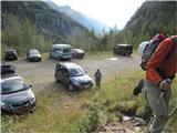
From the Karawanks Tunnel, we follow the highway towards Salzburg to the Gmünd exit. Past the center of the medieval town, we drive into the Malta valley to the place Koschach. On the right we notice the highest waterfall in Carinthia, and on the left a bridge, over which we cross the Malta River and then turn at the first intersection onto the left narrower road steeply upwards into the Gößgraben valley. We drive to a large parking lot below the Goskarspeicher dam, at around 1600 meters. Somewhere on two-thirds of the way the road is closed, when the Giessener Hütte doesn't operate.
Route description:
From the parking lot, we follow the road below the dam to the closed gate, then on the road and on marked shortcuts through sparse forest to the Giessenerhütte (2202 m, 2 hours).
Behind the hut, we follow path 533 (Buderusweg, towards Malniška škrbina – Malnitzer Scharte) to the left, straight ahead runs the path, which later splits and leads either to Winterleitenkopf (2518 m, 45 minutes, easier) or to Hochalmspitze (3360 m, from the hut 4 hours, very demanding) or to Schneewinkelspitze (3016 m, from the hut 3 hours, medium difficulty). We cross a few streams, which flow from the Tripkees glacier. The trail, which is always well marked, leads across the slopes over huge blocks and slabs of granite, in some places made as stairs or small bridges. Caution is needed, because despite large dimensions and weight these blocks are not all stable. Soon from our path to the left branches off path 579, which leads to Tristenspitz and Reisseck. Below Malniška škrbina we cross some snowfields, seeking the best passage, direction indicated by large red dots; follows a few meters of unpleasant scree straight upwards and then with a steel cable secured access to the right into the very notch. In the notch is a memorial plaque to the builders of the path and a statue of Mary. The notch is at 2673 m. From it we spot our goal, below it lake Dosner and the valley to Malnitz. From the notch it is possible to go directly to path 533A, but because of pathless terrain we gain nothing. Better to descend to the marked intersection a few dozen meters below the notch and continue on the partly equipped path 533A below the extremely shattered Grosse Gößspitze. Also here we cross some smaller snowfields (perhaps easier to overcome them with crampons). Path 534 from the Artur-von-Schmid-Haus hut joins us. On the summit slope is a labyrinth of paths, to the left of the marked path there is one nicely cleared (August 2010) and more foot-friendly. Just below the summit also joins the Detmold ridge path (535). On the summit ridge some caution is needed, since the path runs close to the precipitous edge. On the summit is a box with a register book. From the summit we notice a cross, which is placed a few meters lower, at the end of the western superferata. The view is as befits a three-thousander. The trip is more strenuous than demanding, requires absence of fear of depths, reliable step, some prior high-alpine experiences. From the hut 3 and a half to 4 and a half hours.

Along the route: umetno jezero Goesskarspeicher (1707m), koča Giessener Hutte (2202m), Malniška škrbina -Malnitzer Scharte (2673m)
Photos:
 1
1 2
2 3
3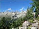 4
4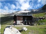 5
5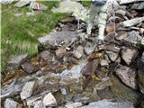 6
6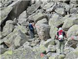 7
7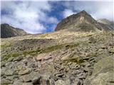 8
8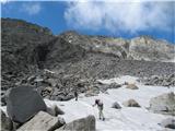 9
9 10
10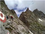 11
11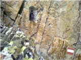 12
12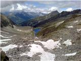 13
13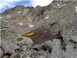 14
14 15
15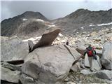 16
16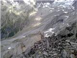 17
17 18
18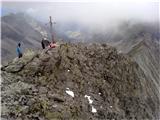 19
19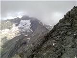 20
20 21
21
Discussion about the trip Gößgraben - Säuleck (Buderusweg)
|
| geppo20. 08. 2010 |
Beautiful valley..
I was wandering here last year, but on the other side of the valley.
|
|
|
|
| geppo20. 08. 2010 |
Sorry for the Slovene mistakes - unfortunately I don't have my glasses with me!!
Regards
|
|
|
|
| VanSims4. 09. 2011 |
Very strenuous path. Worst between the small lake before Malniška škrbina, when we start walking on rocks all the way to the junction with the normal route about an hour before the summit. Probably that's why I didn't see a living soul on the path.
There were no snowshoes, they probably make it a bit easier.
Otherwise, be careful descending from Malniška škrbina so as not to miss the path to the summit. The fork (straight to Arthur von Schmidt haus) is not marked right away but only a few dozen meters towards the summit (right), hidden among rock blocks (picture 14).
|
|
|
|
| VanSims4. 09. 2011 |
Just a note that the statue in Malniška škrbina is not of Mary but of St. Barbara.
|
|
|
|
| atoamac4. 09. 2011 |
By what do you distinguish them, namely Mary and Barbara?
|
|
|
|
| VanSims4. 09. 2011 |
It says on the base of the statue... 
|
|
|
|
| clopnamor13. 01. 2014 |
I'm interested in the connecting path between Säuleck and Hochalmspitze. Lp
|
|
|
|
| IgorZlodej13. 01. 2014 |
Look at my post under Säuleck or Mallnitzerscharte, the path runs through there.
|
|
|
|
| goginho218. 03. 2016 |
Is the Säuleck summit stamp at the top, in the hut or doesn't it exist?
|
|
|
To post a comment you must log in:
If you do not yet have a username, you must first
register.