Kropa (Slovenska peč) - Planinski dom Goška ravan (upper part on the road)
Starting point: Kropa (Slovenska peč) (576 m)
Starting point Lat/Lon: 46.2869°N 14.1969°E 
Path name: upper part on the road
Time of walking: 3 h 25 min
Difficulty: easy marked way, easy unmarked way
Difficulty of skiing: no data
Altitude difference: 357 m
Altitude difference (by path): 570 m
Map: Karavanke - osrednji del 1:50.000
Access to starting point:
A) We drive into Kropa, then continue driving towards Železniki and Dražgoše. When Kropa ends, we continue driving along the Kroparica stream, and on the right, still before the left hairpin turn and Slovenska peč, we notice a larger macadam area, where we park.
B) From Besnica (near Kranj) we drive towards Dražgoše, higher above the settlement Podblica we continue in the direction of Kropa. The route ahead leads us past the village Jamnik, then we start steeply descending towards Kropa. Behind Slovenska peč we will soon notice a larger macadam area on the left, where we park.
C) We drive to Železniki, then we follow the signs for Dražgoše and Kropa. The route ahead leads us past the village Jamnik, then we start steeply descending towards Kropa. Behind Slovenska peč we will soon notice a larger macadam area on the left, where we park.
Path description:
From the starting point, along the road that runs by the Kroparica, we ascend to Slovenska peč (Slovenska peč is the oldest preserved smelting furnace in Slovenia, built in the 14th century), opposite which stands the NOB monument; behind the furnace, the signs for Vodice direct us right onto a worse road, which a little further, at the bridge over the Kroparica, turns into a marked footpath.
On the other side of the bridge, the path enters the forest and starts steeply ascending. After approximately 25 minutes of steep ascent, we reach the ridge (on the sign Vreteno), where another path from Kropa joins us from the right.
We continue in the direction of Vodice, passing a smaller cross; the path is also fairly steep further on. Higher up, the path leads us past a smaller spring, above which some views open up temporarily. A shorter fenced section of the path follows, then the path levels out and brings us to the edge of Jelovica, a few steps further to the lower part of Vodiška planina. A shorter walk across the mountain pasture follows, and we arrive at the Partizanski dom na Vodiški planini.
We bypass the hut on the left side, immediately behind it we go right and continue walking along the macadam road. The road quickly enters the forest, through which it first continues without major changes in elevation, then starts to descend gently; at crossroads we continue straight, larger crossroads are marked, where we keep to the direction for Planinski dom Goška Ravan. We follow this road, which runs through the forest all the way to Razpok, to the huts at Razpok, where a nice view of the Karawanks opens up from the edge of the plateau.
We continue slightly left and along the macadam road that leads us along the edge of the plateau. During the gentle descent, nice views of the Karawanks occasionally open up, a little further also of the Julian Alps, where Triglav is clearly visible. The road then retreats slightly left from the edge of Jelovica and brings us to Ažmanov rovt, where there are a few weekend cottages.
We continue along the main macadam road and past the hunting hut, in 10 minutes of further walking we arrive at the Goška Ravan mountain pasture, a little further to the Goška Ravan mountain hut, which is located a few steps left from the road.
Slovenska peč - Vodiška planina 1:30, Vodiška planina - Razpok 1:15, Razpok - Ažmanov rovt 0:30, Ažmanov rovt - Goška Ravan 0:10.
Description and pictures refer to the condition in 2019 (May).
On the way: Slovenska peč v Dnu nad Kropo (583m), Partizanski dom na Vodiški planini (1108m), Razpok (1002m), Ažmanov rovt (960m)
Pictures:
 1
1 2
2 3
3 4
4 5
5 6
6 7
7 8
8 9
9 10
10 11
11 12
12 13
13 14
14 15
15 16
16 17
17 18
18 19
19 20
20 21
21 22
22 23
23 24
24 25
25 26
26 27
27 28
28 29
29 30
30 31
31 32
32 33
33 34
34 35
35 36
36 37
37 38
38 39
39 40
40 41
41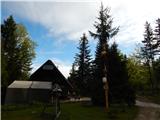 42
42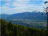 43
43 44
44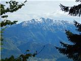 45
45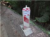 46
46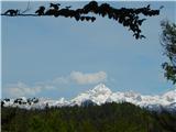 47
47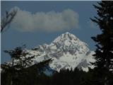 48
48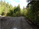 49
49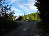 50
50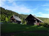 51
51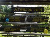 52
52 53
53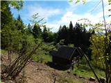 54
54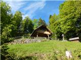 55
55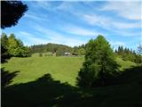 56
56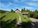 57
57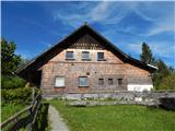 58
58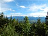 59
59