Kühtai - Sulzkogel (normal approach from Kühtai)
Starting point: Kühtai (2020 m)
| Latitude/Longitude: | 47,21371°N 11,02469°E |
| |
Route name: normal approach from Kühtai
Walking time: 3 h 30 min
Difficulty: easy marked way
Elevation gain: 996 m
Elevation difference along the route: 996 m
Map: Stubaier Alpen Sellrain, 31/2 1:25.000
Recommended equipment (summer):
Recommended equipment (winter): ice axe, crampons
Views: 1.530
 | 5 people like this post |
Access to starting point:
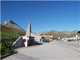
From Ljubljana, we drive on the highway past Salzburg in the direction towards München. At the multilevel junction Dreieck Inntal we go on the road A93 in the direction of Innsbruck/Kufstein/Brenner. When we return to Austria we continue on the highway A12 to the junction with the exit 87-Zirl-Ost. There we join the road L13 and follow it to the Sellraintal valley. A wide and comfortable road further leads past the settlements Sellrain, Gries and St. Sigmund and through a long tunnel, after which after approx. 20 km of moderate ascending we find ourselves in the tourist hamlet Kühtai. The best option for parking is the free parking lot at the chapel and the bus stop just after the sign which marks the beginning of the village, and in case it is occupied, the hamlet offers numerous alternative options. It is also possible to drive through the village and start the ascent at Dortmunder Hütte; in this case there will be a slightly bigger altitude difference, but a somewhat more direct path towards the artificial lake Finstertal.
Alternatively, we can drive through northern Italy: in this case from central Slovenia on the highway A2 we drive to one of the border crossings with Austria and continue towards Lienz. Here we continue on the road 100 and past the pass Prato alla Drava we drive into Italy. In Italy we follow the road SS49 all the way to the junction with highway A22 in the direction towards the Brenner pass. After the pass we continue in the direction towards Innsbruck and then a few more kilometers in the direction towards Bregenz to the exit 87-Zirl-Ost. From there we continue according to the instructions above.
Route description:
Just above the high mountain chapel in the eastern part of Kühtai we notice a signpost, which points us towards the west towards Sulzkogel and the artificial lake Finstertal. After a few minutes of easy crossing above Kühtai, the path turns towards the south and starts lightly descending towards the plain, which is situated approximately 50 altitude meters lower than the starting point and from which we can clearly see the continuation of the path towards the viewpoint above the lake, situated left of the dam above us. The footpath, to which soon joins the path coming from the direction of Dortmunder Hütte, then for some time moderately ascends on a grassy slope, crossing torrents several times. A little higher we cross the mountain road a few times and after a good hour of walking from the starting point above the tunnel we ascend to the viewpoint above the northern edge of the artificial lake, where there is a big panorama board, and a nice view opens towards the massif Zwölferkogel, which hides Sulzkogel behind it.
The path further leads mostly horizontally on the left side above the lake (or above the hollow in which it was situated) and after a little more than half an hour of comfortable walking brings us to its southern edge below the rocky formation of Finstertaler Schartenkopf. At the end of the crossing above the lake, at the signpost we continue straight in the direction towards the southwest (sharply left - towards the east - the path branches off towards Finstertaler Scharte).
From the junction onwards, the path starts moderately ascending and first crosses larger streams, soon thereafter on a steep slope where snow lies most of the year, it ascends a little more markedly to a spacious gravelly basin below the massifs of Sulzkogel and Gamskogel, which is usually still snow-covered in the first half of July, but due to the undemanding terrain and relatively gentle relief usually causes no major problems. After less than half an hour of relatively gentle walking on the path running along the right edge of the plain, the markers direct us upwards towards the ridge on a somewhat crumbly slope.
On a smaller saddle below the rocky formation of Sulzkogel we turn right and follow the footpath, running over gravel with occasional sizable rocks of the wide summit ridge, in zigzags to a fairly spacious and very panoramic summit.
The tour, due to its technical simplicity and relatively small altitude difference along the path as well as the notable quality of the panorama from the summit, offers an enticing opportunity for an easy ascent to a three-thousander, but it is sensible to avoid the ascent in summer heat due to the sun-exposed position and the gravelly terrain.

Along the route: Finstertaler Stausee (2335m)
Photos:
 1
1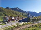 2
2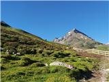 3
3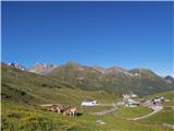 4
4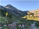 5
5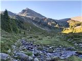 6
6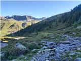 7
7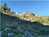 8
8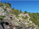 9
9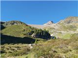 10
10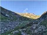 11
11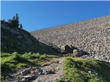 12
12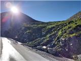 13
13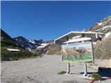 14
14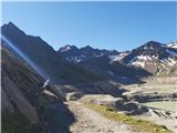 15
15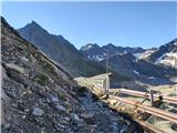 16
16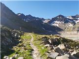 17
17 18
18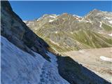 19
19 20
20 21
21 22
22 23
23 24
24 25
25 26
26 27
27 28
28 29
29 30
30 31
31 32
32 33
33 34
34 35
35 36
36 37
37 38
38 39
39 40
40 41
41 42
42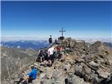 43
43
Discussion about the trip Kühtai - Sulzkogel (normal approach from Kühtai)
To post a comment you must log in:
If you do not yet have a username, you must first
register.