Logarski kot - Rjavčki vrh (Planinšca) (via Grlo)
Starting point: Logarski kot (900 m)
| Latitude/Longitude: | 46,37440°N 14,61320°E |
| |
Route name: via Grlo
Walking time: 3 h 15 min
Difficulty: difficult pathless terrain
Elevation gain: 998 m
Elevation difference along the route: 1000 m
Map: Grintovci 1:25000
Recommended equipment (summer): helmet
Recommended equipment (winter): helmet, ice axe, crampons
Views: 8.930
 | 3 people like this post |
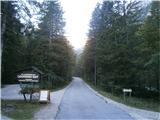
Access to starting point:
We drive to Luče (to here from Mozirje or over Kranjski rak) and further towards Logarska dolina. Soon after the village Solčava we arrive at a crossroads, where the road to Logarska dolina branches off to the left. We turn left towards Logarska dolina (toll payment) and drive along the road to the signs for Gostišče Logarski kot. We turn left and park on the parking lot right next to the guesthouse.
Route description:
Past the guesthouse we head to the right below the headwall of Grlo. Grlo is a quite distinct gully above Logarska dolina, to the left of the walls of Planjava and to the right of Rjavčki vrh. The path ascends moderately; at the beginning it is necessary to climb a few rocky jumps, which in dry conditions do not present difficulties. After approx. 45 minutes of walking we arrive at a section of the path where the remains of pitons help us to proceed. This part of the path is somewhat exposed. Continuing, we keep to the right side along the wall of Planjava; the path, with the aid of some old preserved blazes, leads over rocky jumps in pleasant climbing straight upwards. Once we have climbed the rocky steps, the path turns left (not straight ahead - wall) and becomes relatively visible.
We follow it along the left side in zigzags upwards. The path brings us, after a further hour of walking, into the cirque below Rjavčki vrh and Planjava. In the cirque, with the help of cairns, we notice a modest path on the left side and follow it over strenuous scree upwards to the saddle by which Rjavčki vrh is connected to the main ridge (to the right Škarje).
From it to the left without major difficulties pathless towards the north in a few minutes to the precipitous summit.
From the summit we have an excellent view into Logarska dolina and on the northern walls of Ojstrica.

The trip can be extended to the following destinations: Matkov kot
Photos:
 1
1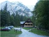 2
2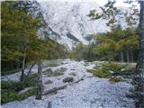 3
3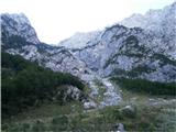 4
4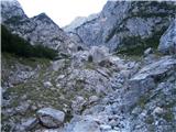 5
5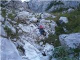 6
6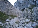 7
7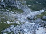 8
8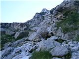 9
9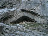 10
10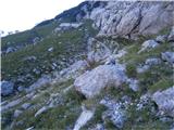 11
11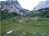 12
12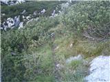 13
13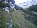 14
14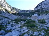 15
15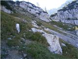 16
16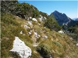 17
17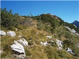 18
18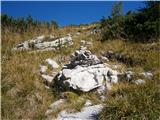 19
19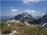 20
20
Discussion about the trip Logarski kot - Rjavčki vrh (Planinšca) (via Grlo)
|
| tone15330. 09. 2012 |
I've gone the described trail twice already and admit that each time a bit differently. Orientation is not really easy. The old markers have mostly faded and are also rarer, the path sometimes disappears. The trail is also quite steep, so your knees hurt. But you're rewarded with wonderful views of the north face of Planjava and the feeling that you're walking where not everyone goes.
|
|
|
|
| amarilis1. 10. 2012 |
After some consideration (despite the poor forecast), we decided on a trip to Logarska dolina. There were quite a few blunders, as the markings were rather poor; the path also got lost several times. The path climbed, we had to climb rocky jumps; after a strenuous scree slope, we reached the saddle. We were rewarded with a magnificent view of the north face of Planjava. We'll return. Regards
|
|
|
|
| garmont1. 10. 2012 |
The path used to be marked, but today it is neglected. We are talking about pathless terrain, so following the "path" is accordingly.
|
|
|
|
| pohodnik388. 07. 2013 |
On Saturday I walked this trail which really thrilled me despite the rather gloomy weather I enjoyed it. The whole trail offers a very nice view towards the head of the Logar Valley and the mountains above it. Lots of flowers and peace on the trail which is most valuable. The feeling was like you are all at home and I'm the only one wandering in the mountains I'll go this trail again. I'll go this trail again.
VIDEO
Best regards! Tone
|
|
|
|
| pohodnik3814. 07. 2013 |
A few more photos of views and moments from this lesser-known path.
PHOTOS
|
|
|
|
| franjo6629. 03. 2014 |
What are the conditions for the ascent to Rjavški vrh (Planinšca)?
Thanks
|
|
|
|
| geppo29. 03. 2014 |
Conditions are mixed. At the start avalanche terrain, icy slabs, sinking in places. Towards Rjavčki it's already avalanche danger after 9 o'clock.
Fresh tracks all the way under the S wall of Ojstrica (loose snow) up to Klemenča.
I can send you a photo if you're interested.
Total 6 hours to Klemenča (descent).
best
and recommend proper equipment of course...
otherwise it's fantasy.....
|
|
|
|
| Gorazd1115. 07. 2024 14:41:51 |
Today I did the ascent through Grlo to Rjavči vrh. You can see that not many people really go there, but it's still possible. You have to be quite careful, especially since the path is almost gone, the markings have faded as mentioned, but some appear here and there, so you know you're not off track. You rarely hit a shrub. On the exposed section there are still 4 pegs. It's quite strenuous and goes uphill non-stop. To the summit time-wise as stated, about 3h. But it's really peaceful and you're alone with yourself.
|
|
|
To post a comment you must log in:
If you do not yet have a username, you must first
register.