Starting point: Mačkovec (752 m)
| Latitude/Longitude: | 45,61480°N 14,96950°E |
| |
Walking time: 15 min
Difficulty: easy unmarked way
Elevation gain: 78 m
Elevation difference along the route: 78 m
Map:
Recommended equipment (summer):
Recommended equipment (winter):
Views: 952
 | 1 person like this post |
Access to starting point:
A) We drive to Kočevje, where from the traffic-light intersection we continue in the direction of the settlement Koprivnik. We then drive past the cemetery, after which Kočevje ends and the road leads us through the settlements Cvišlerji, Zgornji Cvišlerji and Onek. When the settlement Onek ends, a road branches off to the right, which leads towards the center of the village Mačkovec, and we continue on the main road towards Koprivnik, which we follow to an intersection, where a road branches off to the left towards Lovski vrh. We park at an appropriate place near the intersection.
B) From Črnomelj we drive towards Kočevje, a little before the settlement Nemška Loka we turn right towards Koprivnik. From Koprivnik we follow the signs for Kočevje, somewhat past the settlement Laze pri Oneku we arrive at an intersection, where a road towards Lovski vrh branches off to the right. We park at an appropriate place by the intersection, where a macadam road which leads to Lovski vrh branches off.
Route description:
From the starting point, we head onto the road in the direction of Lovski vrh, which after a few steps becomes macadam. A gentle to moderate ascent follows on the macadam road, which in a few minutes brings us to a smaller intersection by a nearby house.
We continue on the left road, to which from the intersection ahead the signs for Roška pot join, and we follow the road to the nearby peak, where there are a few transmitters, the chapel of St. Anne and a hunting cottage from which a beautiful view opens up.
Description and pictures refer to the condition in January 2020.
Photos:
 1
1 2
2 3
3 4
4 5
5 6
6 7
7 8
8 9
9 10
10 11
11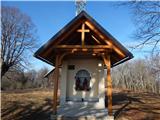 12
12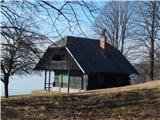 13
13 14
14
Discussion about the trip Mačkovec - Lovski vrh
To post a comment you must log in:
If you do not yet have a username, you must first
register.