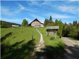
Planinski dom Goška Ravan - Partisan cottage on Vodiška planina (by road)
Starting point: Planinski dom Goška Ravan (933 m)
Starting point Lat/Lon: 46.3167°N 14.1337°E 
Path name: by road
Time of walking: 2 h 5 min
Difficulty: easy marked way
Difficulty of skiing: no data
Altitude difference: 175 m
Altitude difference (by path): 210 m
Map: Karavanke - osrednji del 1:50.000
Access to starting point:
A) From highway Ljubljana - Jesenice we go to the exit Naklo, Podtabor or Brezje, and then we continue driving in the direction of Kropa. At the crossroad, where in the direction of straight road continues towards Kropa we turn right and further we drive through Kamna Gorica. Ahead we for some time still drive through the valley Lipniška dolina, and then we turn left in the direction of Spodnja Lipnica and hunting cottage Lovska koča na Taležu. After the hamlet Kolnica road becomes a macadam and it starts ascending, and at the crossroads, we follow it in the direction of Goška Ravan, where we park on a parking lot near the mountain hut.
B) From highway Jesenice - Ljubljana we go to the exit Lesce or Radovljica, and then we continue driving in the direction of Radovljica and later village Lancovo, Lipnica and Kamna Gorica. Further road over a bridge crosses the river Sava and on the other side it gradually starts ascending. The path ahead leads us through Lancovo, and then we descend into a valley Lipniška dolina, where we soon turn right into Spodnja Lipnica, from there we continue driving towards Talež. After the hamlet Kolnica road becomes a macadam and it starts ascending, and at the crossroads, we follow it in the direction of Goška Ravan, where we park on a parking lot near the mountain hut.
Path description:
From the parking lot near the mountain hut on Goška Ravan we continue on the macadam road in the direction towards the vantage point Suharna, Vodice, forestry cottages Martinček, Rovtarica, Lipniška planina and Bohinj. The road quickly passes into the forest, where at first leads past the hunting cottage LD Jelovica and past some individual holiday cottages. When the forest gets thinner and we get to a larger number of holiday cottages, we are on Ažmanov rovt.
When holiday cottages end the road returns into the forest, and a little further we again get by the edge of Jelovica, from where a nice view towards Juliian Alps and part of Karawanks opens up. After the panoramic part follows few minutes of a light ascent and we get to Razpok, where there are few cottages, and from the edge of plateau a wonderful view opens up on Gorenjska and Karawanks.
From Razpok, where from the left joins the path from Spodnja Lipnica, we continue straight, and the road turns slightly right and it returns into the forest, through which it starts lightly ascending. Further follows few crossroads, where we continue straight, larger crossroads are marked, there we follow the signs for Vodice or mountain pasture Vodiška planina. Higher, the road which all the time runs through the forest flattens, and then past another a little bigger crossroad, where we again continue in the direction of Vodice, it eventually brings us to the mountain pasture Vodiška planina, where there is the cottage Partizanski dom.
Goška Ravan - Ažmanov rovt 0:12, Ažmanov rovt - Razpok 0:33, Razpok - Vodiška planina 1:20.
Description and pictures refer to a condition in the year 2019 (May).
On the way: Ažmanov rovt (960m), Razpok (1002m)
Pictures:
 1
1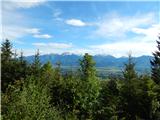 2
2 3
3 4
4 5
5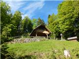 6
6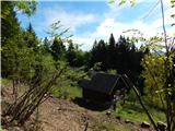 7
7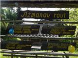 8
8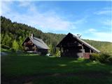 9
9 10
10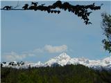 11
11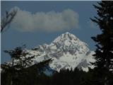 12
12 13
13 14
14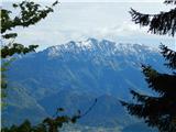 15
15 16
16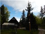 17
17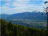 18
18 19
19 20
20 21
21 22
22 23
23 24
24 25
25 26
26 27
27 28
28 29
29 30
30 31
31 32
32 33
33