Starting point: Poklon (922 m)
Walking time: 1 h 15 min
Difficulty: easy marked way
Elevation gain: 479 m
Elevation difference along the route: 500 m
Map:
Recommended equipment (summer):
Recommended equipment (winter):
Views: 96.380
 | 2 people like this post |
Access to starting point:
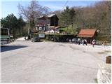
From Ilirska Bistrica over the border crossing Jelšane we drive towards Rijeka. We leave the highway towards Rijeka at the Jurdani exit and follow the road ahead to the settlement Matulji, where signs for Učka direct us to the right. We follow this road, which then ascends quite steeply, to a large parking lot on Poklon.
Route description:
By the parking lot, we will notice signposts for Vojak, which direct us onto a wide path (poor road) that gently ascends on the left side of the boarding house Učka (a restaurant near the parking lot). After just a few steps, the road leads us into the forest, where it turns into a pleasant footpath. A well-marked path, which moderately ascends through the forest, further on crosses the asphalt road a few times. Higher up, the path leads us past a small spring and soon after brings us to the Forest Teaching Trail. Here, we continue straight along the marked path, which, after a further moderate ascent, leads us to an asphalt road that we then follow all the way to the transmitters on Učka. When the road ends, we continue left along an increasingly scenic path, which brings us to the lookout tower on Vojak in five minutes.
The description and pictures refer to the condition in 2008 (April).
Photos:
 1
1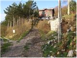 2
2 3
3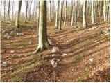 4
4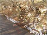 5
5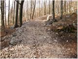 6
6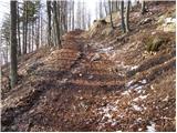 7
7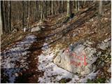 8
8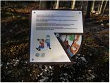 9
9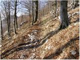 10
10 11
11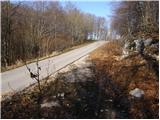 12
12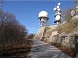 13
13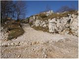 14
14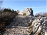 15
15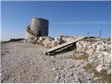 16
16
Discussion about the trip Poklon - Vojak
|
| hribi17. 03. 2009 |
From Poklon to Vojak I went on Saturday, March 14, 2009. Very nice path through the forest, at top superb 360° views. At the sign before the hut on Poklon I read why it's called Poklon, emphasis on the first o. Pilgrims who worshiped the Virgin Mary at nearby Trsat also came to Učka. At this place, with great view to Trsat with the Mary Church, they always bowed to her.
|
|
|
|
| rubberneck13. 04. 2009 |
We were on Vojak yesterday, 12 April 2009. Weather nice, warm. Unfortunately view wasn't good. I imagine though that with clear air the view is wonderful.
|
|
|
|
| hribi15. 04. 2009 |
Does anyone know where the name of the peak Učke - Vojak comes from.
|
|
|
|
| mvrenc30. 05. 2009 |
For the toponym Učka it is said that it originated from the word Vučka gora, or from the word Uska gora. The Italians called Učka Monte Maggiore, which would translate to "great peak", and its old Istrian-Romance name is Caldiera, translated as cauldron. I haven't found an explanation in the literature for the name of the Vojak peak itself, so I'll try to find out and write it!
|
|
|
|
| velijo20. 10. 2009 |
I'm wondering if anyone has recently walked the path to or on Učka from Mošćenička Draga through the village of Trebišća. I walked this path about 20 years ago and I remember that no road reached the village and consequently the village looked like from a fairy tale, as it seemed frozen in time. Is it still like that??
|
|
|
|
| mvrenc26. 04. 2010 |
The path from Mošćenička Draga, then over the village Potoki, where a couple of people live, further is a slightly wider trail that a tractor can pass, to the currently uninhabited village Trebišća. Last year from the village Trebišća a mythical-educational trail to Perun was made, specially marked with blue color or standard marked path to the village Mića Učka, further to the saddle and to the top of Vojak. Even today the village Trebišća looks as if time stopped a hundred years ago!
|
|
|
|
| Francih26. 04. 2011 |
Has anyone gone from Lovran or Lovranska Draga to Vojak? I'm also interested if you can get there by bus?
|
|
|
|
| julius26. 04. 2011 |
From Lovran there is a very nice path to Učka (Vojak). The path is well marked, so you can't miss it. I recommend that the bus takes you to Poklon and from there you continue on foot to Učka (Vojak), then from Vojak to Lovran-to the sea. In Lovran, the bus will be waiting for you.
Best regards.
|
|
|
|
| žabac2. 08. 2011 |
If you want a nice excursion and go by BUS, then Poklon - Vojak - Mala Učka - Babin Grob - Lovranska Draga and there the bus awaits you and then to the sea for swimming..
2. Poklon-Vojak-Suhi Vrh-Vrata-Lovranska Draga and again to the bus and to swim...
|
|
|
|
| soruam14. 09. 2011 |
Does anyone know if the path from Vojak to Suhi vrh is marked and what the distance is?
|
|
|
|
| mvrenc20. 09. 2011 |
From the tower at the top to the saddle 15 minutes, but from the saddle to Suhog vrh about 20 minutes. The path is quite poorly marked, but visible and you can't get lost.
|
|
|
|
| Rok45630. 09. 2011 |
Hello! Can anyone tell me how long it takes to the top from Lovran or Lovranska Draga?
|
|
|
|
| jedriličar30. 09. 2011 |
From Lovran about 3.5 hours, from Lov. Draga one hour less. Recommend the path from Medveja (by the camp), much nicer and more interesting, even though there's a variant to join the path from Lovran to this one from Medveja. Best regards
|
|
|
|
| krsto7128. 10. 2011 |
And does anyone know if there is a circular path Poklon - Vojak - Suhi vrh - Poklon?
|
|
|
|
| jedriličar29. 10. 2011 |
It exists. From Vojak descend to the saddle, then from there towards the signpost to Suhi Vrh. When you reach Suhi Vrh, you need to return approx. 300m back along the path you came and then cross an unmarked path through the forest to exit onto the Sedlo - Vrata path and descend on that path through Vrata (approx. 200 m elevation loss) until you find the junction for Poklon (otherwise that path leads down to Medveja or Lovran). Sounds a bit complicated like this, but if you have a map, everything would be clear. In any case, a circular tour can be made, returning to the starting point, the parking lot at Poklon. Nice outing ....
|
|
|
|
| klaudio19. 02. 2012 |
Poklon saddle Vojak Poklon 18.02.2012.
|
|
|
|
| mimi3332. 05. 2019 |
Great path, not too demanding, but with nice views.
|
|
|
|
| jprim15. 08. 2024 19:21:37 |
Then you surely know the path to Vojak. I was in this area a few days ago. We were at the top at 10 o'clock, although it took us a bit more than an hour to drive to the starting point.
It was quite hot, and you can't believe it, when we were returning from the top, we met numerous hikers, including some in sandals only, even children among them.
I was horrified watching these naive tourists, like - let's go to Vojak, it's totally easy.
Regards!
|
|
|
To post a comment you must log in:
If you do not yet have a username, you must first
register.