Polhov Gradec (Severjeva hiša) - Severjev grič (Unofficial path)
Starting point: Polhov Gradec (Severjeva hiša) (378 m)
| Latitude/Longitude: | 46,06603°N 14,31546°E |
| |
Route name: Unofficial path
Walking time: 5 min
Difficulty: partly demanding unmarked way
Elevation gain: 23 m
Elevation difference along the route: 23 m
Map: Ni potreben, pot je sicer vrisana v OpenStreetMap
Recommended equipment (summer):
Recommended equipment (winter): crampons
Views: 293
 | 1 person like this post |
Access to starting point:
Car:
From Ljubljana and most other parts of Slovenia, we get to Polhov Gradec by leaving the bypass road at Vič (exit Ljubljana-west), driving straight at the first traffic light (crossing Tržaška cesta), and turning left at the next traffic light (direction Dobrova). In Dobrova, we drive into the local roundabout and leave at the first exit (direction Polhov Gradec), then continue driving all the way to Polhov Gradec.
If we drive on the Primorska highway, we can leave at the Brezovica exit, continue straight at the first traffic light after the exit (crossing the old Ljubljana - Vrhnika road), proceed through Podsmreka to the end in Razori, where we turn left onto the road from Vič. Soon follows the roundabout in Dobrova, which we leave at the first exit (direction Polhov Gradec) and continue towards Polhov Gradec.
From the northwest areas of Ljubljana (Šiška, Šentvid, Podutik, etc.), we can reach Polhov Gradec by leaving Ljubljana on Podutiška road, initially heading west, then turning south after a small mountain pass and crossing Stranska vas. Either in Dobrova or in Šujica, we reach the main road from the Dobrova roundabout, turn right here, and continue to Polhov Gradec.
We can also reach Polhov Gradec by driving on the road between Vrhnika/Horjul and Gorenja vas, where at a marked turnoff below Butajnova we turn east and reach Polhov Gradec through Briše.
When we arrive in Polhov Gradec by any route, we park somewhere suitable near the town center (e.g., near the mansion; on appropriate days when it’s not crowded, we can also park at the primary school or cemetery/church).
Public transport:
From Ljubljana to Polhov Gradec, the integrated LPP line number 51 takes us. Similarly, during school hours, integrated LPP lines also connect Polhov Gradec with Črni Vrh (line 52) and Suhi Dol (line 53) along the road between Horjul and Gorenja vas. The bus stop in Polhov Gradec is located right below Severjev grič.
Route description:
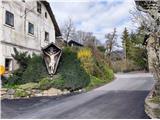
The starting point of the ascent is at the junction by the so-called Severjev cross, i.e., a beautiful cross dated 1715. From the bus stop, we head north. The road towards the mansion and Črni Vrh overcomes the altitude difference in a few turns, which pedestrians can shorten using the stairs renovated in 2023. At the end of these stairs, Severjeva house and the starting junction with the cross are already located.
From the Polhov Gradec church of the Nativity of Mary, we set off on the road towards the east. After just a few meters, the main road begins to gently curve to the left (towards the mansion), but at this point, we take a "slight right," first descending the stairs and then continuing east along a narrow access path, which ends at the starting junction with the cross on our left.
From the Polhov Gradec mansion, we set off on the main road towards the south. On the road, which gently curves to the left, after about 200 meters, we reach the starting junction, recognizable by the only two houses on the left side of the road along the entire section, with the cross visible opposite them on our right.
If we stand a meter or two north of the cross on the main road and turn towards the east, two houses are in front of us. On the left is a newer orange house with number 18, and on the right is an older (also heritage-protected) gray house, which should bear number 17 but has no visible plaque. Right on the boundary between the plots of both houses, we notice a well-trodden path heading uphill. We step onto the low wall by the road and immediately begin ascending the steep path, sticking to the clearly visible trodden route until the end. After a few meters of ascent, the path turns to the right, levels out for a meter or two, until we reach the southern edge, where we turn left and begin steeply ascending again. Soon, the path emerges from the forest and, after a short traverse of the steep southern slope, reaches the western peak next to a cross and flag, which is also the highest point and offers views of the surroundings.
If we wish to continue, from the pole with the flag, we proceed east over the remains of ash, where we turn right and find a trodden path that initially descends steeply into the forest. It soon turns left and reaches a saddle a few meters lower. At the saddle, we already spot and, by traversing the steep southern slope slightly around, ascend to the eastern peak, which, unfortunately, offers no views due to vegetation. If we wish, we can continue further east along a now much less trodden path. We descend again and, after a few meters, reach a small "terrace" at the easternmost point, which, due to trees, offers quite limited views of Pristava at Polhov Gradec (part of the settlement on the left bank of Božna). Continuing the path is not possible, as the "terrace" is surrounded by vertical walls on all other sides.
Description and pictures refer to the condition in March 2023.

Photos:
 1
1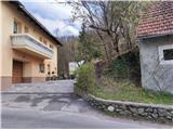 2
2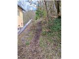 3
3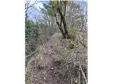 4
4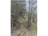 5
5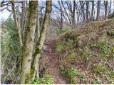 6
6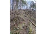 7
7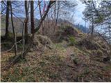 8
8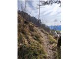 9
9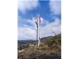 10
10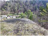 11
11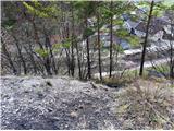 12
12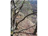 13
13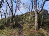 14
14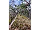 15
15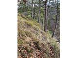 16
16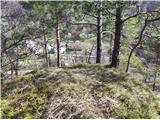 17
17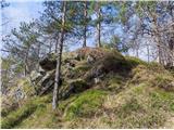 18
18
Discussion about the trip Polhov Gradec (Severjeva hiša) - Severjev grič (Unofficial path)
To post a comment you must log in:
If you do not yet have a username, you must first
register.