Povlje - Storžič (through southwest groove)
Starting point: Povlje (710 m)
| Latitude/Longitude: | 46,32960°N 14,37680°E |
| |
Route name: through southwest groove
Walking time: 4 h
Difficulty: easy marked way
Elevation gain: 1422 m
Elevation difference along the route: 1422 m
Map: Karavanke - osrednji del 1:50.000
Recommended equipment (summer):
Recommended equipment (winter): ice axe, crampons
Views: 142.624
 | 4 people like this post |
Access to starting point:
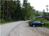
a) From the Ljubljana-Jesenice motorway take the Brnik exit, then when reaching the Mengeš-Kranj road, continue left towards Kranj. Drive along the main road towards Kranj to the first roundabout, from which take the first right exit towards Šenčur. Continue through Šenčur on the main road, then when reaching the Kranj-Zgornje Jezersko road, continue right towards Jezersko. When arriving in Preddvor leave the main road and continue driving left towards the centre of the mentioned place, from there follow the signs for Bašelj settlement. Just after Bašelj settlement the road descends to the Milka stream and crosses it over a bridge. Here first a road branches right to the village Babni Vrt, a good 100 m further also to the village Povlje. Continue on the ascending road towards Povlje, park on a small parking lot above the village. At the starting point there is a small intersection, several hiking direction signs and a large information board of the Trstenik walking-educational trail "path under Storžič".
b) From the Jesenice-Ljubljana motorway take the Kranj west exit, then continue driving towards Golnik. When arriving in Tenetiše leave the main road towards Golnik and continue driving right towards Trstenik. Approximately 1 km after Trstenik settlement arrive at a small intersection, where continue left towards Povlje village. Continue on the ascending road towards Povlje, park on a small parking lot above the village. At the starting point there is a small intersection, several hiking direction signs and a large information board of the Trstenik walking-educational trail "path under Storžič".
Route description:
From the parking lot continue on the left road, from it immediately slightly right onto the footpath towards Storžič, Kališče, Planina Javornik and Dolenčeva path to Velika Poljana. The path ahead first gently, then moderately ascends through the forest, soon leading us to a forest road. Continue the ascent on the occasionally steeper forest road, where due to numerous junctions carefully follow the markers, leaving the forest road several times as the markers occasionally lead along a trail. For some time we still walk on the trail and alternately on the forest road, on the slope that was badly damaged by weather disasters, so there are several large clearings along the path.
Higher, at the marked junction continue towards Storžič, Kališče and Planina Javornik (the forest road continues to Velika Poljana). From the junction the path becomes quite steep, as the already steep old path became impassable due to numerous fallen trees, then the path turns right and temporarily flattens. A few-minute traverse to the right follows, then we step out of the forest and arrive at the southwest gully of Storžič, along which we ascend to the nearby marked junction.
From the junction continue left (straight to Storžič, which bypasses Krničarjeva hut and is about a minute shorter) and transversely ascend the scenic slope to Krničarjeva hut on Planina Javornik.
Continue on the right side of the hut and proceed towards Storžič (left, westwards leads the path to Velika Poljana). Briefly traverse the slopes to the right, then return to the southwest gully, where we rejoin the path we left a little below the hut, and paths from Bašelj or Lašči join us.
Again continue towards Storžič and begin ascending the mentioned gully. Higher, from the left another path joins, leading below the slopes of Psica.
From the mentioned junction continue right (left Velika Poljana, Dom pod Storžičem...) and continue ascending the fairly steep southwest gully of Storžič. Along the mentioned gully, from which increasingly beautiful views open towards Gorenjska, we ascend for another good hour, then the path turns slightly right and brings us to the southwest ridge of Storžič, where an unmarked path joins from the right, leading along the mentioned ridge.
Continue along the ridge, the marked path then turns slightly right and soon other paths from Dom pod Storžičem and Kališče join us. From here to the summit, which we already see ahead, only a short ascent follows with wonderful views.
Starting point - first refreshment point 0:45, first refreshment point - junction below Planina Javornik 1:10, junction below Planina Javornik - Planina Javornik 0:05, Planina Javornik - junction in southwest gully 0:40, junction in southwest gully - Storžič ridge 1:05, Storžič ridge - Storžič 0:15.

Along the route: Prva okrepčevalnica (998m), Razpotje pod Planino Javornik (1355m),
Krničarjeva koča na planini Javornik (1390m), Razpotje na vzhodu Planine Javornik (1407m), Razpotje v jugozahodnem žlebu (1622m), Razpotje na grebenu Storžiča (2048m), Razpotje pod vrhom Storžiča (2114m)
Photos:
 1
1 2
2 3
3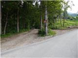 4
4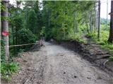 5
5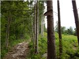 6
6 7
7 8
8 9
9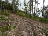 10
10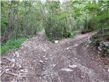 11
11 12
12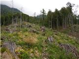 13
13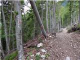 14
14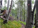 15
15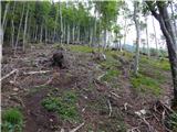 16
16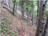 17
17 18
18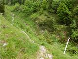 19
19 20
20 21
21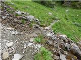 22
22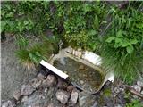 23
23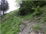 24
24 25
25 26
26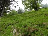 27
27 28
28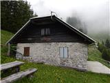 29
29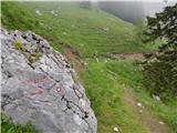 30
30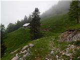 31
31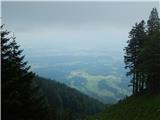 32
32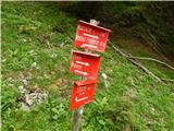 33
33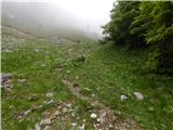 34
34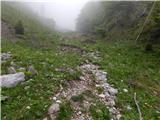 35
35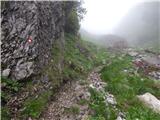 36
36 37
37 38
38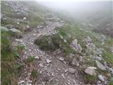 39
39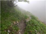 40
40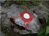 41
41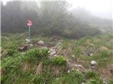 42
42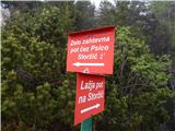 43
43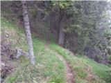 44
44 45
45 46
46 47
47 48
48 49
49 50
50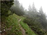 51
51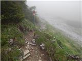 52
52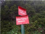 53
53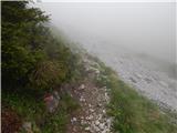 54
54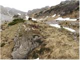 55
55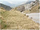 56
56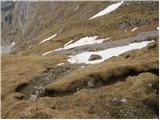 57
57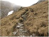 58
58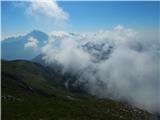 59
59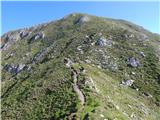 60
60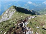 61
61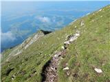 62
62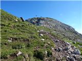 63
63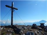 64
64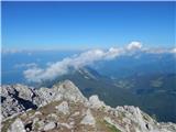 65
65 66
66
Discussion about the trip Povlje - Storžič (through southwest groove)
|
| heinz12. 07. 2009 |
Currently the path above the alpine pasture (10th and 11th picture) is destroyed by avalanches, meaning we walk on muddy pathless terrain for a while. Otherwise not dangerous.
I recommend the path to everyone who is not thrilled by 'airiness' or exposure.
|
|
|
|
| Leyla26. 09. 2009 |
Today I was on Storžič via this path. Markings to the village of Povlje are very poor (to all starting points it's well marked already on the road), moreover nowhere is it marked that this path leads to Storžič. Also when we reach this "parking", there are mentioned markings, but you didn't write WHAT is written on those markings... PD Kokrica shaped this path themselves and only you know that you go up to Storžič here.
By the way, the estimated walking time for an average hiker is from car to Storžič summit average 4 hours up and 3 hours down.
Write real data and don't mislead people, because I don't care how much time a mountain runner spends here, but a hiker!
|
|
|
|
| velikanka26. 09. 2009 |
Tomorrow I'm going towards Storžič exactly via this path that you describe Leyla. What do you suggest? You scared me a bit... 
|
|
|
|
| milosj27. 09. 2009 |
The author of the description had the best intentions, no doubt. Anyway, no panic, the village Povlje can be found, the parking lot which is visible on the picture too is not hard to find. It's a bit out of the village at the bend.
I joined this path last week at Javornik (from Gradišče), and from Javornik to the top I used 1 hour 30 minutes of normal walking. The destroyed path is already trodden in, so just boldly...
|
|
|
|
| heinz27. 09. 2009 |
I myself with the help (only) of this description here easily found the starting point and the right path to the summit.
The data are (were) purely realistic and do not apply to fast hikers, nor to those who "cause delays"..
Good luck, heinz!
|
|
|
|
| Bojan_A27. 09. 2009 |
There is absolutely nothing wrong with this description. Anyway, map in hand. 
Everything is nicely drawn there too. Leyla: for such a long tour you must count at least on a deviation of +/- 15 minutes. That's barely 6 percent in this case. 15 minutes doesn't mean much for an average hiker.
|
|
|
|
| Leyla29. 09. 2009 |
From the village, hiking paths are marked with red signs, from Povlje there is nothing marked that you go up to Storžič here. The orientation of this 1st picture, where the parking is, is taken from the direction when you come down from Storžič...hello (?) I'm not interested in what the parking looks like when you come from Storžič, but what it looks like when you come by road! Then they could at least write here what this path is called, which is nicely written when you start walking.
Well, the path itself is nice, but also very strenuous, as you are steeply ascending all the time, which seems to apply to all variants to Storžič anyway. I
Regarding the time, I already mentioned my opinion.
Best regards
|
|
|
|
| Bojan_A29. 09. 2009 |
This path is the easiest of all to Storžič. But it is very steep.
Advice: don't go to the mountains alone without a sense of orientation in your own backyard.
In other words, I want to say that this with pictures on Hribi.net is pure pampering. Especially with those arrows it was way over the line. Then Sunday hikers in the mountains screenshot pictures and think they can now walk alone in the high mountains, preferably off-trail.
Unfortunately, that's how it is. Good intention achieved the opposite effect. (To go to the mountains you also need to know just from description or easier paths on the map)
I know this post will attract harsh criticism. I won't mind them, because (as a mountain guide) I know this happens.
|
|
|
|
| heinz29. 09. 2009 |
Bojan, you're right, even though I drew the arrows on the pictures in good faith.. specifically because of the opinion that the photo doesn't show everything as it is in reality (which is ultimately a fact)..
The purpose certainly isn't just to print out the pictures.. and that should be (supposedly) enough, even though (hand on heart), the descriptions on Hribi.net for most hikes are so nicely and accurately written that you can rely on them. Maybe sometimes even more than on some other descriptions and maps...
No, no, there won't be harsh criticism at least from my side.
Good luck, Bojan!!
|
|
|
|
| Leyla30. 09. 2009 |
Need to experience a bit more and gather some experiences...
|
|
|
|
| skorny24. 07. 2010 |
On Thursday I set off from Polje via Javornik to Storžič. I recommend this trail to those who get "vertigo" because this path is not exactly "dangerous" but the whole trail is damn steep - it doesn't ease off even 10 meters, you need fitness to manage it. I started at 06:15 from the parking lot in Polje and reached Storžič at 09:15 with a stop at Javornik. The last and first water is at Javornik so I recommend stocking up there. But the whole path at that hour was in shade so the heat doesn't bother you.
|
|
|
|
| skorny24. 07. 2010 |
There is a mistake in the starting point, it is the village Povlje and not Polje
L.P.
|
|
|
|
| Iguana28. 07. 2010 |
Wow, this girl Leyla sure knows how to get really mad, awesoooooome. I don't know why so much controversy about times, are they all competing? Fine by me, I prefer to enjoy the ascent without watching the clock.
Let's leave those complications aside.
I've read all the descriptions and comments. Storžič has been pulling me for a long time, but I don't know which path to take: from Povelj, Laški, or choose the one from the village Mače, which appeals to me the most as a path, but it says it's partially difficult, which doesn't seem so from the description and photos. A bit of vertigo is spoiling my good mood, that's why not all hills are reachable.
Thanks for your opinions and a pleasant mountain greeting to all.
|
|
|
|
| jprim28. 07. 2010 |
Iguana, that girl was angry a year ago ... now she might be in a better mood.
Where to start for the easiest path, I can't advise you, browse the descriptions - you'll find an easy approach, I only know the more difficult ones.
LP!
|
|
|
|
| jprim28. 07. 2010 |
Well, I think the description of that path is right above.
|
|
|
|
| Iguana29. 07. 2010 |
I noticed the date, but I had to add it, it was itching me. itching me.
I know this one above is described as easy. From the pictures, the one from Mač appeals to me the most. I wouldn't want to be a hero and risk never being able to go up anywhere again. Thanks for your comments.
Good luck to all.
|
|
|
|
| jprim29. 07. 2010 |
If you mean from Mač and then past the hut at Kališče, I advise against it, since you mention vertigo, on this path you sometimes need to step well and hold onto some rock.
Of course the ones via Škarje and Žrelo are harder.
LP!
|
|
|
|
| Bojan_A4. 08. 2010 |
Today I was training. After the rain I expected it to be slippery, but it was still okay for running. The whole path was pleasantly in fog so it wasn't hot. At the top it cleared up and there was a good view.
|
|
|
|
| nemelk5. 11. 2010 |
Today I went from Povel to Storžič. The path is easy but physically demanding as your knees hurt the whole way. The path is well marked, but at the beginning you need to follow the blazes because leaves have covered the trail. The path was very dry for this time. The starting point where you park the car has a sign only for Velika Polana. Weather was ideal without wind. Walking 2h 35.http://www.hribi.net/slike/tongue.gif
|
|
|
|
| sabina196721. 06. 2011 |
Following the instructions we had with us today, we found our way perfectly. It's true that at the parking lot there's only a sign for Velika Poljana, but we followed the instructions to head to the footpath between the two roads. The sign with "Dolenčeva cesta" will help you. The path is super, even though it bites your knees. It's super marked. On the way back we turned from the gully to Velika Poljana and avoided a substantial part of the gully. The path to Velika Poljana is beautiful and the hut there is wonderful and worth seeing. We nicely made a loop and returned to the same starting point.
|
|
|
|
| Mikič28. 08. 2011 |
Yes, you can really get there in 2h 35 min. I recommend it to everyone who doesn't like rappels and pegs. The path doesn't give you much time to rest, it's quite steep all the way. Today at 8:30 it was cold enough for a hat and gloves at the summit. In short, great tour.
|
|
|
|
| Marky10. 01. 2012 |
Would anyone go on Saturday 14.1.2012 (if conditions and weather are ok) to Storžič?
|
|
|
|
| jelen10. 01. 2012 |
I plan to go to Storžič on Friday, Saturday already has other plans.
|
|
|
|
| Marky12. 01. 2012 |
Jelen, if you're going up tomorrow (Friday), please report what the conditions are like. Unfortunately I can't tomorrow (weekday).
Thanks..
|
|
|
|
| redbull12. 02. 2012 |
Hello
Is it possible to go to Storžič via this path in these conditions or is it too dangerous due to avalanches.
Let someone report here if by chance anyone has been up there after February 10th.
Thanks
Best regards Dejan
|
|
|
|
| Marky14. 02. 2012 |
Dejan, when do you plan to go up?
I'm probably going up on Thursday 16.2. (all depending on avalanche conditions), just not sure yet which path.. probably from Mač or Lašky.. if you want, you can join me/us..
Regards
|
|
|
|
| ljubitelj gora14. 02. 2012 |
I might skip it now, but short thaws are coming, also the sun is already quite strong, southern grassy slopes are dangerous (I know the summer path that goes on the southern side and there was a lot of downed scrub from avalanches), so in my opinion better to use the path from Kališče and even there is a short section on grassy slope (logically better to stay on the ridge all the time but it's too exposed), of course no one will write here, because that puts someone in danger, one must be aware that currently degree 3, by Saturday it might drop to 2, windy past days so cornices, windslabs... for more better wait for a local who knows Storžič inside out.
|
|
|
|
| mc128. 03. 2012 |
Has anyone gone up this path to Storžič in the last few days? What are the conditions?
Thanks,
Best, Matej
|
|
|
|
| Alni9. 07. 2012 |
How much macadam is there on this path by car and what is the road like? Thanks
Which marked path do you recommend more? Which is nicer?
|
|
|
|
| juhejnaprej9. 07. 2012 |
There is no macadam to Povelje, except at the parking lot, but this is the easiest trail to Storžič in terms of difficulty, and at the same time slightly harder in terms of fitness because not a meter of the trail is flat but it goes steadily uphill without pause. On the trail via Kališče you sometimes have to grab a rock, but the trail is more varied and with changing steepness.
Personally, from Povelje I prefer it over via Kališče because of the impressive gully we walk through and because it is usually less crowded.
|
|
|
|
| Alni9. 07. 2012 |
Thanks!
Deciding between Storžič, Grintovec and Stol. We plan to visit all three anyway but I'm interested in what order you would choose them regarding difficulty/condition readiness? (all three trails planned via easy marked paths)
|
|
|
|
| Kriška9. 07. 2012 |
My choice in this case would be:
1. Stol
2. Grintovec
3. Storžič.
|
|
|
|
| svetilka31. 07. 2013 |
To make it easier to find:
3. From the Ljubljana - Jesenice motorway, take the Brnik exit, at the first roundabout turn left, at the second right to Šenčur. Then drive towards Preddvor (Visoko, Hotemaže, Tupaliče). In Preddvor follow signs for Bašelj, go through Bašelj (follow signs for Golnik and Trstenjak). We arrive at a junction where the road to Babni Vrt branches right. Here go straight and after a few hundred meters we reach the next junction, where we turn right to Povlje. We drive through the village uphill to a small parking lot, where there is a large sign for the circular excursion route (junction of asphalt and gravel roads). At this parking lot there is no sign for Storžič, only for Velika Poljana.
|
|
|
|
| Daaam31. 07. 2013 |
@svetilka.. I dare say faster and better variant is Kranj west exit, direction Kokrica/Mlaka, further to Golnik to village Tenetiše. In village turn right, further through Trstenik to left turnoff to Povelj..and of course that one kilometer further to parking..
|
|
|
|
| garmont1. 11. 2014 |
Due to ice breakage, about 5 minutes from the start the trail is rerouted on another path and only joins the old trail high in the forest below planina Javornik. But it is cleared and completely newly marked, so no problems with followability.
|
|
|
|
| Zgembo9. 05. 2015 |
I was on this tour today, no snow even for a sample
|
|
|
|
| matej7128. 11. 2015 |
Hiked today. The path is in excellent condition. In the lower part there are quite a few forest roads crossing the path, but enough markings so no orientation issues. But the whole path is one big 'knee eater', the higher you go, the steeper. Crowded at the top. The summit is also quite 'shat' with sheep droppings, hope something is done about it. Can't imagine it in slightly wetter weather.
|
|
|
|
| robi210723. 12. 2016 |
Today I climbed this path. The upper description is correct, but some of the photos are not, as in my opinion they were taken on the approach from Velika Poljana, specifically on the section between the Psica - Storžič junction to the junction of this path with the path from Krničarjeva koča on Planina Javornik (on Geopedija this section is marked G2770, on Pešpoti portal ID 11649). In my opinion, photos from 40 inclusive to 52 inclusive do not belong. We do reach the junction in photo 52, but not from the left (from the direction of the mentioned fork), as shown in the photo, but from below (from the direction of Planina Javornik).
Otherwise, the other photos are fine. One of the above discussants took issue with the parking lot in photo 1, saying it's taken from the direction of Storžič. That's not true. The photo is perfectly fine, as the path into the forest is clearly visible in the background. However, the photos especially of the lower part through the forest to Planina Javornik are quite scarce. From the comments, it's clear that quite some time has passed since the upper path description was added. Since then, the forest has changed considerably due to natural disasters (bark beetle, ice storm), there have been many clearings (even clearcuts). The consequence is that a huge number of markers on (felled, broken) trees have disappeared. Therefore, you really need to keep your eyes peeled and sometimes look around well to spot the next marker that will guide us further. For orientation aid, there is also a sufficiently trodden path to follow. Another consequence is several new forest skid trails that cross the forest footpath. Mostly, you can find the continuation of the path on the other side of the skid trail, but at the last one, the marked path completely disappears. The reason is that this path was "swept away" by the new skid trail, which razed both the path itself and all the trees with markers. Especially at the beginning, when the footpath brings us to this skid trail, above it we spot 2 markers on trees, but we don't pay attention to them, as those two trees stand by the path, which is soon replaced by the mentioned skid trail. Therefore, we follow it to the right and after about 100 m at the end of the skid trail we spot the continuation of the marked path. Otherwise, I will post photos of the problematic sections on the forum for better illustration.
There was some talk in the comments about walking time. On the sign that greets us right at the start of the path, the ascent time is marked 3 hours, the author of this description noted 4 hours. If we consider that in one hour we do 300 to 400 m ascent, roughly both times would be appropriate, but the first suits racers more, the second ordinary mortals with a kilo extra and some crosses on their back. On Geopedija, for example, the ascent time is marked 4.5 hours if we bypass Krničarjeva koča and go directly from the spring towards Storžič (otherwise a few more minutes). The fact is that the path is extremely steep. The average slope on the entire trail is 36%, in the lower part of the gully between Planina Javornik and point Storžič JZ (on Geopedija G2803) over 43%, in the upper part between point Storžič JZ and Storžič J (on Geopedija G2193) even 48%. In addition, the path doesn't allow much rest. Thus, on the entire trail we descend only 8 m over a total distance of 50 m, but ascend 1404 m over a total distance of 3848 m (data for the direct path bypassing Krničarjeva koča). Accordingly demanding is also the descent, especially in the upper part of the path. Nevertheless, the path is safe and technically undemanding, although section G2193 in the PZS Cadastre of mountain paths is marked as demanding. Perhaps it is marked as such due to the steepness of the ascent. Therefore, I dare say that the path is also suitable for physically well-prepared beginners.
|
|
|
|
| navdušena16. 07. 2023 05:33:28 |
Yesterday we descended part of the path. From the summit to Planina Javornik it took us more than an hour. The path is really veeery steep. I don't know if one and a half hours, as written on the sign, is the real time, I'd say two hours rather. For normal hikers.
We descended via Sv. Lovrenc to Laško (Bašelj), where we started the path. Delicious donuts at Lovrenc, I recommend the parking lot! Why drive as high as possible, as far as possible... possibly even complain about the road, if they have arranged a parking lot just for us, mountain visitors!?
|
|
|
|
| xtrinch26. 06. 2025 09:53:29 |
Excellent path, perhaps a bit poorly marked, especially at the beginning where we got lost, we went further along the road, you have to go right uphill immediately from the overgrown parking lot. At the bottom parking lot there are two paths marked: 4:50 ahead along the road and 3:00 right uphill (the correct one). Then on the path across the clearing at one of the rest spots it's easy to turn left towards Polana, but you need to go straight across the clearing. If you stick to going practically always uphill on this path, it's hard to stray. :-) 4 hours will hold true, below it says 3, but that's time for more regular alpinists :-) We descended via Kališč, which is a bit off-path and considerably more dangerous on the upper section.
|
|
|
|
| DVas26. 06. 2025 10:37:55 |
Last week descended the gully, very unpleasant.
|
|
|
To post a comment you must log in:
If you do not yet have a username, you must first
register.