Starting point: Predgrad (374 m)
| Latitude/Longitude: | 45,50433°N 15,05606°E |
| |
Walking time: 1 h 15 min
Difficulty: easy marked way
Elevation gain: 367 m
Elevation difference along the route: 385 m
Map:
Recommended equipment (summer):
Recommended equipment (winter): ice axe, crampons
Views: 9.340
 | 2 people like this post |
Access to starting point:
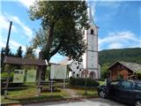
A) We drive to Kočevje, and then we continue driving in the direction of Delnice. In Livold we leave the main road towards Croatia and we continue left in the direction of Črnomelj and Vinica. Further, we drive through the settlements Mozelj, Rajndol, Knežja Lipa, Brezovica pri Predgradu, where the road turns sharply to the right, Čeplje, Zagozdac and Jelenja vas to the settlement Predgrad, where at the church of St. Sebastian we park on the parking lot at the information boards.
B) From Vinica or Črnomelj we drive to Stari trg ob Kolpi, from there we continue driving in the direction of Kočevje, and we drive only to Predgrad, where we park on the parking lot in front of the church of St. Sebastian.
Route description:
Signs for Kozice from the parking lot direct us onto the road, where we walk for a short time in the direction of Kočevje, after a few dozen steps behind the nearby house we continue left downwards on a side road, by which there are signs for Kozice. The descent soon ends, and the road changes into a cart track, and we continue to the marked junction without major changes in elevation.
At the junction we leave the cart track and continue right upwards towards Kozice (straight Dol), where we start to steeply ascend through the forest. Through the forest we follow the signs of the forest path Kozice, which is marked with an oak leaf. Higher we temporarily continue on the cart track for some time, after the sinkhole at Graščica, which is 23 meters deep, the cart track narrows into a mountain path. There follows some more occasionally steep ascent through the forest, then occasional views start opening up, where the path splits. Both the left and right paths bring us in a few minutes to the RTV transmitter on the top of Kozice, where there is a stamping box.
For a nice view it is worth continuing left in the direction of the viewpoint, to which we arrive after less than 5 minutes of descent.
Description and pictures refer to the condition in August 2020.

Photos:
 1
1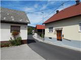 2
2 3
3 4
4 5
5 6
6 7
7 8
8 9
9 10
10 11
1112
 13
13 14
14 15
15 16
16 17
17 18
18 19
19 20
20 21
21 22
22 23
23 24
24 25
25 26
26 27
27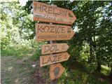 28
28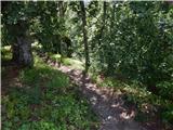 29
29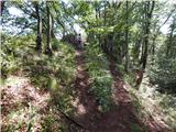 30
30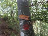 31
31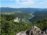 32
32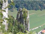 33
33 34
34 35
35
Discussion about the trip Predgrad - Kozice
To post a comment you must log in:
If you do not yet have a username, you must first
register.