Rifugio Scoiattoli - Rifugio Averau
Starting point: Rifugio Scoiattoli (2255 m)
Starting point Lat/Lon: 46.5189°N 12.0379°E 
Time of walking: 30 min
Difficulty: easy marked way
Difficulty of skiing: no data
Altitude difference: 158 m
Altitude difference (by path): 158 m
Map: Tabacco 03, 1:25.000
Access to starting point:
A) From Kranjska Gora over Korensko sedlo to Austria, where at the first larger crossroads we continue left towards Podklošter / Arnoldstein and Trbiž / Tarvisio. At the end of the settlement Podklošter signs for Šmohor / Hermagor point us right onto a regional road, on which past the mentioned settlement we drive to the end of the Gailtal valley, or more precisely to the settlement Kötschach-Mauthen, where we turn right towards the settlement Oberdrauburg. The route ahead leads us over the Alpine pass Gailbergsattel (982 m), after which we descend into the mentioned settlement. After crossing the bridge over the river Drau, we continue left towards the settlement Lienz. In the main roundabout in Lienz we continue "left" in the direction of the settlement Sillian and Italy. Further, we cross the border between Austria and Italy, and we follow the main road to the settlement Dobbiaco / Toblach, where we turn left towards Cortina d'Ampezzo. When we arrive in Cortina d'Ampezzo, we follow the signs for the Alpine pass Passo Falzarego. The road above Cortina d'Ampezzo starts to ascend more steeply, and we follow it for quite some time, more precisely to the spot where just before a sharp right turn a road branches off to the left, by which we quickly arrive at the large parking lot at the hut Rifugio Bai de Dones. Then we buy a ticket and take the four-seater chairlift to the hut Rifugio Scoiattoli. From Kranjska Gora to the starting point is 208 km.
B) From Kranjska Gora over the border crossing Rateče to Trbiž / Tarvisio and further on the highway towards Udine. We leave the highway at the settlement Tolmezzo, from where we continue driving towards the settlement Ampezzo and further towards the Alpine pass Passo della Mauria (1298 m). The road then starts descending and brings us into the Cadore valley, where we continue right towards the settlement Auronzo di Cadore. At the next crossroads we follow the signs for Cortina d'Ampezzo. When we arrive in Cortina d'Ampezzo, we follow the signs for the Alpine pass Passo Falzarego. The road above Cortina d'Ampezzo starts to ascend more steeply, and we follow it for quite some time, more precisely to the spot where just before a sharp right turn a road branches off to the left, by which we quickly arrive at the large parking lot at the hut Rifugio Bai de Dones. Then we buy a ticket and take the four-seater chairlift to the hut Rifugio Scoiattoli. From Kranjska Gora to the starting point is 198 km.
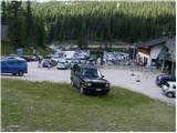
C) From Nova Gorica we drive into Italy and continue on the highway to the settlement Portogruaro, where at the highway junction we turn in the direction of Belluno. We follow the highway to its end (we do not turn towards Belluno), then we continue driving towards Cortina d'Ampezzo. When we arrive in Cortina d'Ampezzo, we follow the signs for the Alpine pass Passo Falzarego. The road above Cortina d'Ampezzo starts to ascend more steeply, and we follow it for quite some time, more precisely to the spot where just before a sharp right turn a road branches off to the left, by which we quickly arrive at the large parking lot at the hut Rifugio Bai de Dones. Then we buy a ticket and take the four-seater chairlift to the hut Rifugio Scoiattoli. From the border crossing to the starting point it is approximately 230 km.
Path description:
From the mountain hut Rifugio Scoiattoli, from which there is a nice view of Cinque Torri, we head right following the signs for Rifugio Nuvolau and Rifugio Averau. The path ahead leads us along a stony road, or a much more pleasant parallel mountain path for hiking, which ascends along the left side of the road. After more than 20 minutes of moderate ascent over a panoramic slope that is initially also grassy, the trail splits into two parts (the junction is unmarked).
The left path, which continues along a moderately steep slope, leads to Nuvolau, while we continue along the right path, which joins the previously mentioned road. We continue along the road, which brings us into a small valley between the peaks Nuvolau and Averau, and we follow it all the way to the saddle between both mentioned peaks, where the mountain hut Averau stands.
Pictures:
 1
1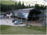 2
2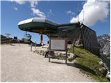 3
3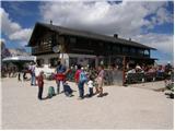 4
4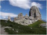 5
5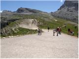 6
6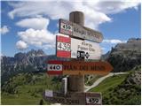 7
7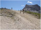 8
8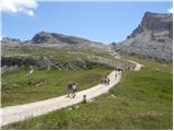 9
9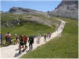 10
10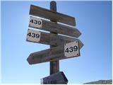 11
11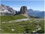 12
12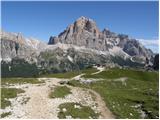 13
13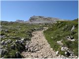 14
14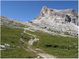 15
15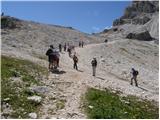 16
16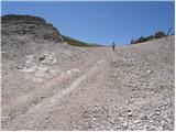 17
17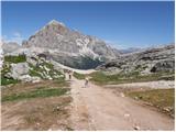 18
18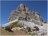 19
19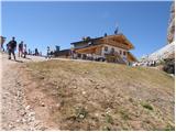 20
20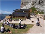 21
21