Smolnik - Veliki Šumik waterfall (through valley of Lobnica - Holcarska pot)
Starting point: Smolnik (440 m)
Path name: through valley of Lobnica - Holcarska pot
Time of walking: 2 h 10 min
Difficulty: difficult marked way
Difficulty of skiing: no data
Altitude difference: 510 m
Altitude difference (by path): 510 m
Map: Pohorje 1:50.000
Access to starting point:
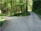
Smolnik is a settlement on the western side of Ruše, geographically it is spreading from Žigartov vrh past the pond Falski ribnik almost to Klopni vrh. From the center of Ruše we drive straight west on the asphalt road towards Činžat or Lovrenc, passing the cemetery on the right side. In Smolnik before the characteristic railway viaduct, the road turns sharply right and then left to the roundabout, and immediately after the roundabout we turn sharply to the left and on a narrow asphalt road we get into the valley of Lobnica. On the road, we drive a little less than 3 more km (from the roundabout), mostly straight, until we get to the spot, where an asphalt road turns sharply right upwards in almost 180 degree corner. At this spot in the direction straight, forest road branches off, here are also well visible signs for mountain path and also the other signposts, so we can't miss this spot. So we go straight on this forest road and after 150-200 meters on the left side there is an appropriate place, where we can park. In case if this spot is taken, after approx 0.2 km on the left side there is another appropriate spot for parking.
Path description:
The path is not orientationally difficult; we only stick to the bottom of the valley, which the stream Lobnica carved through millions of years, additionally shaped by ice ages and weather phenomena. We walk comfortably on a slightly ascending forest road along the left bank of the stream Lobnica, its murmur accompanying us to the destination. In the narrow and deep valley, surrounded by steep and forested areas, there is only enough space for the stream Lobnica and the forest road, which quite quickly turns into a cart track interrupted in some spots by landslides. Along the entire route of our path, the longest water-powered timber slide in Slovenia – Lobniška riža – once operated. Timber was transported along it from 1838 to 1959; with all its branches, it was 17 km long. Besides the stream Lobnica, water from artificial lakes built for this purpose (lake Črno jezero on Pohorje and lake Tiho jezero or Falski ribnik) was also used for additional supply. Except those two lakes, practically no visible remains of chute exist today; very little or almost nothing remains of the sawmills that were in the Lobnica valley and are commemorated by signs along the path (Cebej, Švajger, and Zgornja Globokar sawmills).
Towards the end of the valley, the path briefly crosses to the right bank of the stream Lobnica but soon swings back to the left bank, and a sign shortly alerts us to the remains of the Marinč sawmill on the right side. Besides part of a wall, we should pay attention to the built remains of the water supply system above the ruins with the carved inscription “Marinc-1930.”. ("60 min). We continue walking on the cart track for a short time until blazes direct us to the right, upward into the forest ("10 min). A few minutes ahead in the same direction, on the right bank of the stream Lobnica, stands the Reberska koča, a former dwelling of forest workers. The path quickly becomes steep, and we walk high above the stream Lobnica (carefully—danger of slipping!). We cross over to the top of the ridge, the steepness eases, and we reach a spot where a path from Zg. Smolnik joins from the right ("20 min). We continue straight; along the path, dark green solitary rocks become increasingly frequent and merge above us into the rock formation called Jelenska peč. For botanists, this is an interesting site for rusty saxifrage, which is common only on Pohorje in Slovenia, as it requires acidic soil for growth. The entire surroundings and rock formation are covered with lush vegetation, into which humans deliberately do not intervene to preserve the pristine mixed Pohorje forest. We cross a dangerous torrent gully via a wooden footbridge, which, at 14.5 meters, is the longest bridge on Slovenian hiking paths, built by Podravje trail markers in 2002, as indicated on an information sign before the bridge. The interesting path then leads us to the waterfall Mali Šumik ("25 min). If we want to see the waterfall in its entirety from below, we must descend the steep slope to the stream Lobnica just before the footbridge (unmarked, carefully!) near the spot where remains (steel cables) of a hanging footbridge are visible, which was attractively positioned directly above the waterfall but was unfortunately destroyed by natural forces some time ago. A few meters higher above the waterfall, trail markers have built a replacement footbridge, over which we continue along the right bank of the stream Lobnica. Our gazes are drawn to the frothy water flowing in the riverbed over moss-covered rocks and the remains of tree trunks. After a few minutes, we reach the waterfall of the Verna stream, which we cross with the aid of steel cables; we continue above the Lobnica and arrive at a spot offering the most famous view of the Veliki Šumik waterfall ("15 min).
Pictures:
 1
1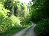 2
2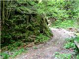 3
3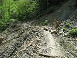 4
4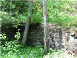 5
5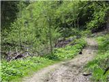 6
6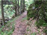 7
7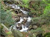 8
8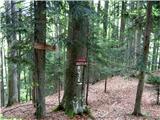 9
9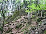 10
10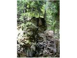 11
11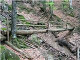 12
12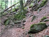 13
13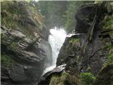 14
14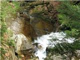 15
15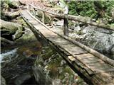 16
16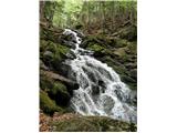 17
17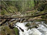 18
18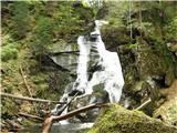 19
19