Srednji vrh - Techantinger Mittagskogel (Trupejevo poldne) (via Železnica)
Starting point: Srednji vrh (960 m)
| Latitude/Longitude: | 46,48940°N 13,83710°E |
| |
Route name: via Železnica
Walking time: 2 h 30 min
Difficulty: easy unmarked way
Elevation gain: 971 m
Elevation difference along the route: 971 m
Map: Kranjska Gora 1:30.000
Recommended equipment (summer):
Recommended equipment (winter): ice axe, crampons
Views: 139.281
 | 7 people like this post |
Access to starting point:
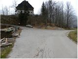
From the highway Ljubljana - Jesenice, we take the exit Jesenice - west (Hrušica) and continue driving in the direction of Kranjska Gora. When we arrive in Gozd-Martuljek, we turn right in the direction of Srednji Vrh and drive to the mentioned settlement on a narrow and steep road. When the road flattens a little, we will come to a crossroad of several roads and a turning point. Here we park in an appropriate place by the crossroad.
Route description:
From the crossroad, we continue on the left ascending road by which we notice signs "Trupijevo poldne". We continue on the mentioned road for some time, then the next sign for the same peak directs us right onto an ascending grassy cart track. The cart track soon turns sharply to the right and ascends diagonally for a short time, then brings us to an unmarked junction, where we continue on the lower right cart track, which after a few minutes of traversing comes very close to the stream Jerman. Further, we moderately ascend along the stream, and the cart track on which we walk crosses the mentioned stream a few times over a bridge. Higher, the path leads past some abandoned huts on Hudi hlevi, then flattens and in a few minutes of further walking brings us to a wider forest road, which we reach at its end (area named Železnica).
From the end of the road, we continue on a wide rocky cart track that continues from the road. The cart track moderately ascends and in 30 minutes of walking through a sparse forest brings us to a clearing, where on the left side we notice a hunting cottage and a spring.
We continue on the path that runs through a small valley and soon brings us to the meadows east of the hunting cottage. Across the meadow, the path is somewhat harder to follow, but when we reach the dwarf pines, we can't miss it again. A nice path then brings us to the saddle between Trupejevo poldne and Lepi vrh (as on the maps, otherwise the peak also has other names: Bele peči, Peči and Na Pečeh), where the path from the mountain pasture Grajšca joins. We continue left and ascend to the summit on a panoramic ridge path through dwarf pines.
The last meters below the summit are slightly exposed and in snow dangerous for slipping (in the dry, undemanding).
Srednji vrh - end of the road 1:15, end of the road - Trupejevo poldne 1:15.

Along the route: Lovska koča Železnica (1700m)
Photos:
 1
1 2
2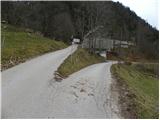 3
3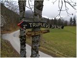 4
4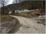 5
5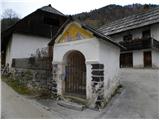 6
6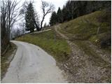 7
7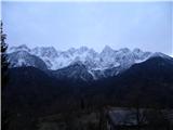 8
8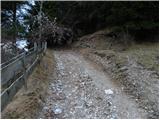 9
9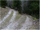 10
10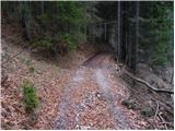 11
11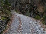 12
12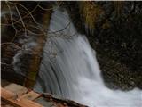 13
13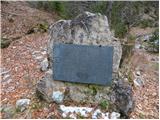 14
14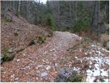 15
15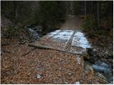 16
16 17
17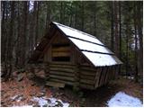 18
18 19
19 20
20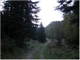 21
21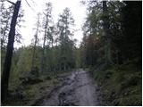 22
22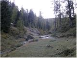 23
23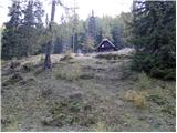 24
24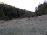 25
25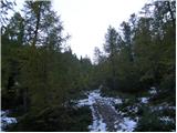 26
26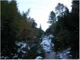 27
27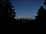 28
28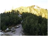 29
29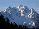 30
30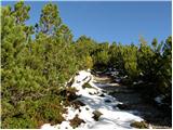 31
31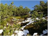 32
32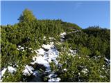 33
33 34
34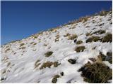 35
35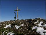 36
36 37
37
Discussion about the trip Srednji vrh - Techantinger Mittagskogel (Trupejevo poldne) (via Železnica)
Show older messages
|
| Gost16. 10. 2007 |
One of the most beautiful hikes, a perfect 10!
|
|
|
|
| heinz9. 01. 2009 |
O.K.
Now it's 9.1.09.
What conditions can we expect tomorrow?
Is it trodden? Icy?
Has anyone been to the summit in the last few days?
Thanks for the answers!
|
|
|
|
| pasavec22. 11. 2009 |
I was at the summit today. There's quite a bit of snow on the path, but it's not "annoying"; there's not (yet) enough to sink in too much, and the trail is well-trodden. Just below the summit, where the path steepens a bit, there's almost no snow or it's mostly bare. The descent from the summit along the ridge to Blekova planina is pleasant. Initially, the path is a bit exposed, but soon it widens and eventually enters the forest. Below the planina, an obvious cart track starts, which we follow down to the valley and after a while join the path we took up to the summit. Otherwise, a pleasant trip...
|
|
|
|
| maremw3. 02. 2010 |
Yesterday we headed towards Trupejevo poldne from Srednji vrh, but only to the clearing before the hunting hut. There were 4 with snowshoes ahead of us, but for us it was sinking knee-deep in the meadow and we turned back. Still a nice trip.
|
|
|
|
| malovrh44. 01. 2011 |
Today did the mentioned tour. Conditions excellent, except a bit of wind on the summit. Snow did not give way. Crampons recommended from the saddle to the summit. Ski touring descent possible approx. 700m less than to the valley.
|
|
|
|
| malovrh44. 01. 2011 |
Today did the mentioned tour. Conditions excellent, except a bit of wind on the summit. Snow did not give way. Crampons recommended from the saddle to the summit. Ski touring descent possible approx. 700m less than to the valley. On the descent found a women's glove - the owner can contact by email.
lp
uroš
|
|
|
|
| gorenjka115. 05. 2011 |
Yesterday we did this nice tour with a colleague  Who knows what happened to the cross and border stone on the top of Trupejevo poldne? Who knows what happened to the cross and border stone on the top of Trupejevo poldne?
|
|
|
|
| Parkeljc15. 05. 2011 |
The summit with the cross collapsed to the Austrian side already last summer!!!
|
|
|
|
| klm15. 05. 2011 |
It couldn't come to us either, because it was always standing on the "Austrian" side!
But that's why it's so much nicer on the summit. Such markers don't belong on summits anyway. I'm afraid something similar will happen to Stolov vrh one day, which is also already decently eroded. Just not with too big a crowd on it then...
|
|
|
|
| Parkeljc16. 05. 2011 |
By the way, the border stone was exactly on the border  , (that's why they exist), as for the cross, it's clear to everyone that the Austrians are obsessed with them, just that, I don't know where they'll put it now, probably in the air. On our side there was also a summit logbook with a bell, which also "went" to the north side. While we're at it, what belongs on summits and what doesn't, probably border stones bother some people too, but that's another topic.. , (that's why they exist), as for the cross, it's clear to everyone that the Austrians are obsessed with them, just that, I don't know where they'll put it now, probably in the air. On our side there was also a summit logbook with a bell, which also "went" to the north side. While we're at it, what belongs on summits and what doesn't, probably border stones bother some people too, but that's another topic.. 
|
|
|
|
| Majdag17. 05. 2011 |
The summit logbook with bell is still there. Checked in April this year, have a nice day Majda...
|
|
|
|
| klm17. 05. 2011 |
Of course it stands - it's on the Slovenian side, south of the border stone - these are, sometimes even welcome - already for orientation, at least on the plevelnica summits, or on Gamskovke in the Košuta ridge...Bavhah...
|
|
|
|
| katty4. 09. 2011 |
Hi.
Can someone tell me, is there a stamp at the summit maybe? Nothing is mentioned in the mountain and path description, that's why I'm asking. We've wanted to go up there with parents several times, but haven't succeeded yet.
Thanks and best regards, Katy
|
|
|
|
| heinz4. 09. 2011 |
In the past there was no stamp there, I don't know how it is now. Still, go up there anyway, you surely won't regret it!
|
|
|
|
| Janiel7419. 05. 2013 |
Yesterday caught a beautiful day on Trupejevo poldne.
The described approach or parking is completely wrong. The parking is lower at the junction. If you drive as indicated here, you almost end up in a barn Also from the Železnica hunting hut I suggest rather the path behind the hut uphill, where you can then make a loop and reach the saddle if you turn right at the first junction. If you go straight, you reach the summit via a nice ridge path.
|
|
|
|
| Serjan29. 06. 2013 |
Hi
As Janiel74 already wrote, the mentioned spot is not a parking lot, because it is the yard of a farm, and I ask everyone to park at the parking lot 100m before at the intersection, marked with parking bays and intended for parking. I also appeal to the article author to correct this information, because I think we all agree that no one benefits if you park in their yard.
|
|
|
|
| ANČIKA22. 07. 2013 |
Hi! I'm interested how much walking there is from Trupejevo poldne along the ridge to Vošca?
THANKS!
|
|
|
|
| aljoša16. 06. 2014 |
Today it takes about 1 hour and 20 minutes at a moderate pace. You can orient yourself by the border stones that are along the trail.
|
|
|
|
| Grenaleva20. 10. 2014 |
Beautiful path, once it leaves the stream valleys, there are no droppings at the top and it's really pleasant to sit. From the top there's a nice path back through Blekova planina, then down the meadow to the road. Larches are beautifully golden in color. The path is marked with ALPE ADRIA trail signs.
|
|
|
|
| malimiha4. 12. 2015 |
Hello, has anyone been up there in the last few days, what are the conditions like? lp
|
|
|
|
| VesnaJager6. 05. 2016 |
Hello,
Has anyone been up there recently? We plan to go on Sunday, and we're interested in what the trail is like. Thanks. Regards
|
|
|
|
| aditaker20. 09. 2017 |
Hello, I'm wondering if there's already any snow up there or if it's still bare ground, as I plan to climb this peak tomorrow and wonder if I can still go up with summer trail running shoes?
|
|
|
|
| dragon20. 09. 2017 |
Today I was on the opposite bank of the Sava at 1700 m altitude. There it was nearly 40 cm. Trupejevo poldne is another 200 m higher!
|
|
|
|
| matej21. 09. 2017 |
Today I visited Klek, snow depth is 0-20 cm. Since it's sunny and warm it's melting quickly, so the situation on Trupej is probably similar. I recommend gaiters and take into account that it's quite muddy.
|
|
|
|
| tango15. 01. 2019 |
I don't know if there can be anything better than it was today at noon at Trupejevo poldne. A couple of cm of new snow, no wind (I couldn't believe it) and a view that makes your head spin. Access easy.
|
|
|
|
| cajer20. 04. 2019 |
Today's conditions: sun, warm, consequently towards the summit (from Železnica onwards) the snow was sinking deeply up to the knees, in some places completely soft. Just below the summit it was the most "challenging" - collapsing, lots of snow, nowhere to step except postholing. We didn't use mini crampons, no need/added value.
The view from the summit was incredible in the sunny weather.
Trail time in difficult conditions and slower pace: 3h up, 2h down.
|
|
|
|
| cajer20. 04. 2019 |
One more thing - soon after the starting point, where there should be a signpost for Trupejevo poldne by the road, it's missing or gone. When you pass the house with the farm along the path, head onto the cart track to the right upwards (it wasn't grassy, but a regular cart track).
|
|
|
|
| Jelkabayta2. 07. 2019 |
Am I the only one having trouble seeing weather forecasts from Wednesday onwards?
|
|
|
|
| Daaam2. 07. 2019 |
Don't take the hribi.net weather forecast too seriously. Check out more specialized sites..
|
|
|
|
| Jelkabayta2. 07. 2019 |
What are you checking, general for e.g. the Julians or do you have something detailed for the peaks?
|
|
|
|
| Kanjanez20. 07. 2019 |
It's really easy pathless terrain; if we follow "Alpe adria trail", we can't miss.
At the top heavenly, special summit, unique cross, mountain scenery accompanies us, especially Martuljek groups. In short, it's worth it
|
|
|
|
| Hribolazec8115. 06. 2020 |
Two days ago I went, I reached the other three Austrian peaks, but couldn't find Trupejevo poldne :/
|
|
|
|
| J.P.16. 08. 2020 |
We park at picture 1, now it's an arranged parking lot. Exceptional views from the top, highly recommend visiting. The pathless section is easy to follow, follow the above description, Alpe adria trail markings or stick to the gravel "road" that leads straight up all the way to the hunting hut. At the hunting hut, turn slightly right. Hribolazec81, next time :-)
|
|
|
|
| zbil21. 11. 2021 08:43:45 |
Alternatively, at the hunting lodge, we can continue straight ahead, which is quite steep, and descend along the ridge to the hunting lodge.
In yesterday's perfect weather, truly magnificent views of the Julian Alps chain, all the way to Montasio, and of course in all directions as far as the eye could see.
|
|
|
|
| tango14. 01. 2022 16:36:53 |
Today's day was ideal. There was a slight breeze on Sr. vrh, but on the summit it was warm and of course cloudless with beautiful views in all directions. TP is really a viewpoint, as they say. The approach was so-so, from Železnica onwards you didn't know if it was better along the trail that wasn't one or straight ahead. In any case, there were some plunges up to the butt, but no big deal. The summit finish wasn't problematic either, secure footing, ground just soft enough, so it went without issues just with the help of poles.
|
|
|
|
| Darxta5. 06. 2022 22:12:20 |
You won't find signs for Trupejevo Poldne anymore. At the starting point there's one sign for Alpe Adria Trail, the next sign only after 15 min of walking.
But 20m past the chapel (picture 6) go right on the cart track, 300m further right again, then the path is unmistakable.
|
|
|
|
| Majdag14. 08. 2023 11:30:02 |
12.8 - The path is very varied, a bit of everything, but nicely passable. Just be more careful with the steps.
In the last part of the path, towards Sedlič, sand spills and the trail is harder to pass. There is a bypass though. Among the scree and at the top the views were wonderful.
https://jelenkamenmajdag.blogspot.com/2023/08/trupejevo-poldne.html
|
|
|
|
| ljubitelj gora22. 10. 2023 22:05:17 |
At the starting point there is parking for 7-8 cars, where it is marked, all others who parked next to it or down below towards Gozd M. received a notice from the traffic wardens. Larches have started to get color, gold will have to wait a bit longer. Came from Blekova vrh to Trupejevo Poldne. The path over Železnica is washed out, lower stones are sticking out.
|
|
|
|
| kapibara1. 11. 2024 14:28:06 |
Be careful to really go right at the junction, which after a few minutes leads to the stream (otherwise you won't see the stream and you're on the wrong path).
Unfortunately, the traffic wardens are still issuing parking fines.
|
|
|
|
| plaNinaPirsMajcen3. 11. 2025 18:54:27 |
Hi, sharing moments from our pleasant hike to Trupejevo poldne.
https://youtu.be/sBXXcmk_Zto?si=Sxu0u_NHWjdIs_EI
We enjoyed the last golden larches, walking on a carpet of soft needles is real balm for the feet 💛🍂
We follow markings for Alpe Adria Trail to Sedlič saddle, then turn left into the bushes and soon spot the famous cross.
We descended along the ridge to the other side and reached the Železnica hunting hut from the other side, making a loop over Trupejevo poldne summit.
Best, Nina
|
|
|
|
| felix3. 11. 2025 20:12:50 |
|
|
|
|
| felix4. 11. 2025 15:45:35 |
Regarding the above comments: if I want to go from Styria to Trupejevo poldne and after three hours' drive arrive at the starting point which is occupied, what then? I park somewhere by the road and get a fine from traffic control. Apparently these Gorenjska local sheriffs have lost it.
|
|
|
|
| Tinca55. 11. 2025 19:10:24 |
If there's no free spot you can park in Gozd M. At the junction for Srednji vrh there's a parking lot. The path extends by a good half hour.
|
|
|
|
| geppo6. 11. 2025 05:01:58 |
Some cars were parked along the road higher than the via ferrata. There's space for at least 5 cars. That's somewhere in the middle and then you have about 15 minutes more to the parking lot. I would drive to the top and if no space, back. On the right along the road next to the wood storage there's quite a large space.
regards
|
|
|
|
| geppo6. 11. 2025 05:02:08 |
Some cars were parked along the road higher than the via ferrata. There's space for at least 5 cars. That's somewhere in the middle and then you have about 15 minutes more to the parking lot. I would drive to the top and if no space, back. On the right along the road next to the wood storage there's quite a large space.
regards
|
|
|
|
| Acibujl29. 01. 2026 12:45:28 |
Does anyone know if you park at those wood storage areas, you don't get a fine or what?
We already got one up there😜 If I park at the official P below, do I have to go up the asphalt to the starting point or is there a path maybe? Thanks for any info.
|
|
|
To post a comment you must log in:
If you do not yet have a username, you must first
register.