Trdnjava Kluže - Kota 1313
Starting point: Trdnjava Kluže (532 m)
| Latitude/Longitude: | 46,36120°N 13,58930°E |
| |
Walking time: 2 h 20 min
Difficulty: easy marked way
Elevation gain: 781 m
Elevation difference along the route: 781 m
Map: Julijske Alpe - zahodni del 1:50.000
Recommended equipment (summer): helmet, lamp
Recommended equipment (winter): helmet, ice axe, crampons, lamp
Views: 29.558
 | 1 person like this post |
Access to starting point:
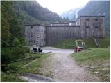
From Bovec we drive towards the border crossing Predel. After a few kilometres along the road we notice Trdnjava Kluže and the parking lot next to it, where we park.
Route description:
From the parking lot we head onto the wide marked path located on the opposite side of the road from Trdnjava Kluže (direction Rombon and Kota 1313). The path, which ascends barely noticeably, takes us after a few minutes of walking to an old military tunnel. Since the tunnel is quite long, a headlamp or other light will be helpful.
After the tunnel the path leads us to a junction, where we continue left towards Na Robu and Kota 1313 (slightly right Možnica). The path then steeply ascends briefly, then continues in a gentle traversing ascent with some views towards the lower Trdnjava Kluže. After about 25 minutes of walking the path takes us to the mighty remains of Hermanova utrdba.
From the fortification we continue right towards Rombon on the path that steeply ascends through the forest upwards. At junctions we follow the marked path or the signs for Na Robu and 1313, higher up only the signs for 1313. After over two hours of walking the path brings us to a beautiful viewpoint, where a view opens towards the nearby Jerebica and other mountains above the Koritnica valley.
The path then enters dense forest again and leads us to a junction, where we continue left on the less visible path following the signs for 1313 (straight to Rombon). The path levels out, turns right and takes us out of the forest to Kota 1313, from where a wonderful view opens over the Bovška kotlina.
Trdnjava Kluže - Hermanova utrdba 0:25, Hermanova utrdba - junction before Kota 1313 1:50, junction before Kota 1313 - Kota 1313 0:05.

Photos:
 1
1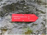 2
2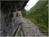 3
3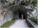 4
4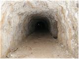 5
5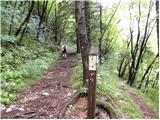 6
6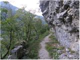 7
7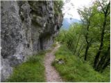 8
8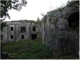 9
9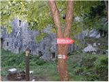 10
10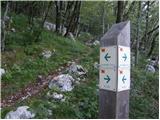 11
11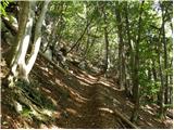 12
12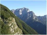 13
13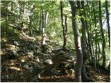 14
14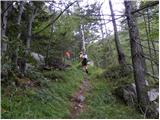 15
15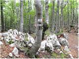 16
16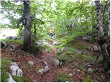 17
17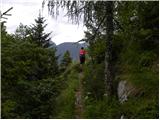 18
18 19
19 20
20
Discussion about the trip Trdnjava Kluže - Kota 1313
|
| Iguana15. 04. 2010 |
The weekend will be nice, I'd like to climb to peak 1313. This description confused me a bit, photo 11, where on both sides of the signpost it says it's to peak 1313. Is there still snow at the top?
Thanks everyone for answers.
|
|
|
|
| divjipetelin15. 04. 2010 |
See the reply for the trip Trdnjava Kluže-Rombon.
Have a nice day
|
|
|
|
| Iguana15. 04. 2010 |
Thanks, I was a bit in "f fear", that these trails aren't viewed by many hikers and that's why I wrote there too.
|
|
|
|
| Zasavčan28. 03. 2012 |
I'm curious about the current conditions on the path to Kota 1313 from Kluže.
|
|
|
|
| ales5028. 03. 2012 |
Everything is within normal limits, so just keep the path under your feet, there are signs that guide you to the goal, nothing thrilling, just watch out for grenades, hehe,
|
|
|
|
| bojan7925. 09. 2015 |
How many minutes/hours of walking from the Rombon - Kota 131 junction (picture 16)?
|
|
|
|
| MANGRT25. 09. 2015 |
45 to 80 minutes depending on pace.
|
|
|
|
| Schriftsteller19. 06. 2016 |
Has anyone been to Kota 1313 recently?
I tried today, but at approx. 1100m a.s.l. suddenly a bunch of fallen trees, then the trodden path disappears and no more markers.
So I turned back at approx. 1300m a.s.l. ...
Only down at Fort Hermann did I remember that coordinates are published on Hribi.net, and iPhone has a compass :-) Next time.
|
|
|
|
| Smetar19. 06. 2016 |
Last December those trees were also on the path, you go a bit up and to the right (under the wall) and after some time you join the path or go directly over the trees... after about 100m elevation gain you're on an unmarked trail that leads to Kota 1313 (if you turn left) or towards Rombon, if you go straight...
|
|
|
To post a comment you must log in:
If you do not yet have a username, you must first
register.