Upper station of cableway (Jastrebec) - Musala (Poletna pot na Musalo)
Starting point: Upper station of cableway (Jastrebec) (2369 m)
Path name: Poletna pot na Musalo
Time of walking: 3 h
Difficulty: easy marked way
Difficulty of skiing: no data
Altitude difference: 556 m
Altitude difference (by path): 600 m
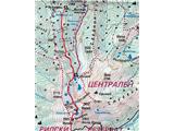
Map: Rila National Park - 1:55000
Access to starting point:
Path description:
On the way: Hiša Musala (2389m), Alekovo jezero (2605m), Hiša pri Ledenem jezeru (2720m), Ledeno jezero (2711m), Hiša na vrhu Musale (2925m)
Pictures:
 1
1 2
2 3
3 4
4 5
5 6
6 7
7 8
8 9
9 10
10 11
11 12
126217137.th.jpg) 13
13 14
14 15
15 16
16 17
17