Vent - Wildspitze (običajna pot mimo Breslauer Hütte in preko Mitterkarjocha)
Starting point: Vent (1895 m)
Starting point Lat/Lon: 46.8605°N 10.91494°E 
Path name: običajna pot mimo Breslauer Hütte in preko Mitterkarjocha
Time of walking: 6 h 30 min
Difficulty: very difficult unmarked way
Difficulty of skiing: more demanding
Altitude difference: 1873 m
Altitude difference (by path): 1873 m
Map: Ötztaler Alpen Wildspitze, 30/6 1:25.000
Access to starting point:
From Ljubljana, we drive on the highway past Salzburg in the direction towards München. At the multilevel junction Dreieck Inntal we go on the road A93 in the direction of Innsbruck/Kufstein/Brenner. When we return to Austria we continue on the highway A12 past Innsbruck, Telfs and Mötz, and then at exit 123 near the Ötztal Bahnhof we turn towards B186/B171/Ötztal/Haiming. The road B186, which runs to Ötztal valley, we follow past settlements Oetz, Längenfeld and the center of the valley, Sölden. Only few kilometers ahead from Sölden at village Zwieselstein we turn on a steep ascending, but comfortable asphalt road towards Vent. In the tourist settlement Vent we park on one of the numerous (payable) parking lots; best just at the parking lot near the bottom station of the chairlift Wildspitze. Parking fee in Vent in the year 2020 was 5 euros/day.
Path description:
From Vent we go on the path which roughly follows the route of chairlift Wildspitze in the direction of the mountain pasture Stablein (a warning: in the summer we can get to restaurant Stablein with a chairlift, which shortens the access for about an hour). Modestly marked, but obvious and wide path in long zig-zags leads through mountain meadows, until it ends at the road at the restaurant on the mountain pasture Stablein.
Near the restaurant we go on a little narrower, but quite comfortable footpath which is in the presence of numerous blazes ascending very gently towards the mountain hut Breslauer Hütte. Not far below the mountain hut with the help of the small bridge we cross glacial stream Rofenkar and the footpath which ascends a little firmly, we follow on the final steepness to Breslauer Hütte. From Vent to the hut there is a little less than three hours of walking.
At Breslauer Hütte we follow signposts for Wildspitze, which point us towards the northeast on (at the beginning still marked) footpath which relatively steeply ascends towards the scree valley between massifs Wildspitze and Brochkogel. The footpath in a gentle ascent crosses above a smaller lake, and then gently continues in the middle of glacial valley.
During the crossing towards the heart of a small valley, which hosts the remains once a wide glacier Mitterkarferner, signs disappear, and occasionally individual cairns will still guide us. After approximately half an hour of a moderate ascent towards the southern walls of Hinterer Brochkogel, the path which is now poorly visible, turns towards the northeast and starts firmly ascending towards the walls below the saddle Mitterkarjoch. A warning: in case of fog in the last part of the ascent through the valley it is often hard to follow optimal direction. In this case it is good to stick more to the north (higher) below the walls, which surround u-shaped valley.
On very crumbly terrain we are ascending towards the rocky barrier below Mitterkarjoch. In the last part of the ascent through a small valley, usually the snow stays the entire year; for safe crossing of steep snow tongue we need full winter equipment. In the last steepness the right path is shown by individual fixed safety gear, which are especially useful in ice.
After the approach towards the walls below Mitterkarjoch follows technically most difficult part of the tour: we have to climb otherwise relatively short ferrata, which ascends steeply over the wall to the saddle. The secured path is the hardest right at the beginning, when we overcome a vertical - on short spot even slightly overhang - level (difficulty C). After that, the path for some time stays moderately demanding and quite exposed (to B/C), and higher it is becoming easier (to B, mostly A/B). After approximately half an hour of ascending on ferrata, the steel cables bring us to a rocky edge, after which we step on the saddle Mitterkarjoch (3470 meters), where a wide view opens up on a wide glacier Taschachferner. Here we prepare for the glacial crossing.
From Mitterkarjoch we continue on a glacier in the direction towards (north)east. Because the ascent on Wildspitze is popular in all seasons, we will probably walk on a beaten track, otherwise we are (at first lightly) ascending north from the cliffs, which are falling towards the ascent valley. Soon after the first time the upper ridge of southern peak of Wildspitze shows up, south from a smaller rocky shoulder in the middle of a glacier we turn around towards the southeast. We follow the glacial path to the foot of final rocky ridge, which leads on Wildspitze. In normal conditions ascent on a glacier lasts approximately one hour.
A warning: even though the traces of predecessors usually avoid the glacial cracks, the caution at the crossing definitely isn't nuisance; because Taschachferner is quite dangerous, cracked glacier.
To the peak follows for approximately fifteen minutes of ascent on quite crumbly ridge, which is in larger part quite wide and undemanding. Just below the summit follows few more difficult rocks, which we have to climb on a slightly precipitous terrain (I). On the top there is a big cross and a wide view.
Although technically it isn't too difficult, the ascent on Wildspitze is long, strenuous and complex high mountain tour, which not skopari with objective dangers (falling stones in the area of valley below the mountain walls of Brochkogel and Wildspitze; steep passages, which are in larger part of the year icy; crevasses when crossing Taschachferner). Despite the popularity of the path, the orientation - especially in inconvenient weather conditions - is relatively demanding. For safe passage of a glacier Taschachferner we need to walk in a roped party and use the full glacial equipment. Even though the secured path on Mitterkarjoch is quite short, in parts, it is quite demanding and exposed, and often icy - because it is entirely above 3400 meters - therefore I recommend also a self-belay set.
Because of the length and big altitude difference, I recommend overnight stays in Breslauer Hütte, in doing so we need to know, that in the high mountain season the mountain hut is often fully occupied.
On the way: Panoramarestaurant Stablein (2365m), Breslauer Hütte (2844m), Mitterkarjoch (3470m)
Pictures:
 1
1 2
2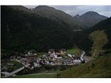 3
3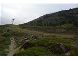 4
4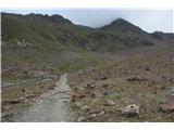 5
5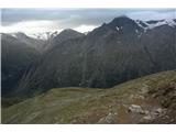 6
6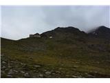 7
7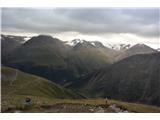 8
8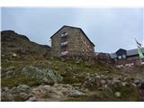 9
9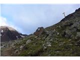 10
10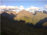 11
11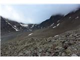 12
12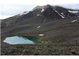 13
13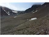 14
14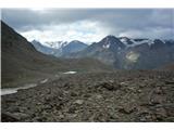 15
15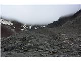 16
16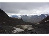 17
17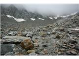 18
18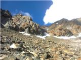 19
19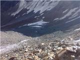 20
20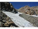 21
21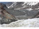 22
22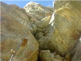 23
23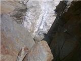 24
24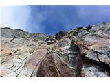 25
25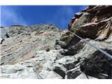 26
26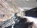 27
27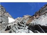 28
28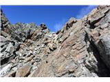 29
29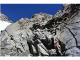 30
30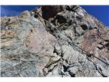 31
31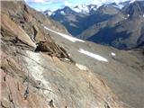 32
32 33
33 34
34 35
35 36
36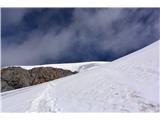 37
37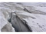 38
38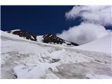 39
39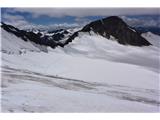 40
40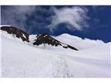 41
41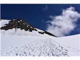 42
42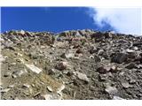 43
43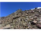 44
44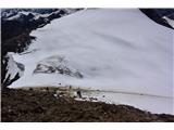 45
45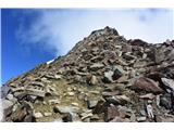 46
46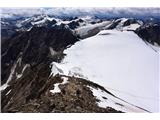 47
47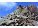 48
48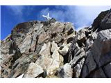 49
49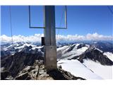 50
50