Vrhnika-tankovska cesta - Koča na Planini nad Vrhniko (Circular path Vrhnika-Planina-Lintvern-Vrhnika)
Starting point: Vrhnika-tankovska cesta (300 m)
| Latitude/Longitude: | 45,96360°N 14,27520°E |
| |
Route name: Circular path Vrhnika-Planina-Lintvern-Vrhnika
Walking time: 2 h 20 min
Difficulty: easy marked way
Elevation gain: 433 m
Elevation difference along the route: 433 m
Map:
Recommended equipment (summer):
Recommended equipment (winter):
Views: 16.325
 | 3 people like this post |
Access to starting point:
If we come from the Ljubljana direction, we start the path on Tankovska cesta, to which we arrive if at the intersection at the last traffic light we turn right (bank, pharmacy...). After just under two kilometers of driving straight, we reach a macadam road beside which we park.
Route description:
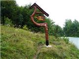
From Tankovska cesta first on a narrow path, then to the houses on Storžev grič a few hundred meters along the road and we are already at the old fruit dryer, at which we continue on the middle path through dense hazel thicket, which in summer offers plenty of shade. Soon the path flattens for a while and we are already at the bench named "Zupanova". Here the path splits into the steeper right one via Špica or the gentler but somewhat longer left one. We choose the right path, which quickly ascends the ridge. To the top it is not far anymore, and the path becomes even a bit steeper. On the summit stands an old lookout tower from the year 1955, which will soon be replaced by a new one. In the cottage at the end of the week we can strengthen ourselves with good homemade food. We continue the path behind the cottage downhill towards Lintvern, where the stream Bela originates. Through the gorge we descend towards the cottage in Starem malnu, where there is a smaller water intake, and below it a renovated water wheel of the former mill. From here we continue along the road towards the starting point, which is approximately 2 km away.

Photos:
 1
1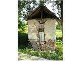 2
2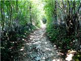 3
3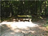 4
4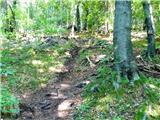 5
5 6
6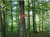 7
7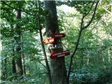 8
8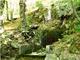 9
9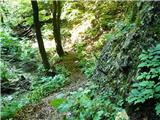 10
10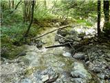 11
11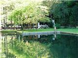 12
12 13
13 14
14
Discussion about the trip Vrhnika-tankovska cesta - Koča na Planini nad Vrhniko (Circular path Vrhnika-Planina-Lintvern-Vrhnika)
|
| Gost18. 09. 2007 |
Great for building fitness and at the same time enjoying the beautiful nature. I recommend!
|
|
|
|
| andrej jerina9. 11. 2008 |
Today, after more than half a year, we visited my "home" Planina again. We started on the tank road, the path was locally wet, muddy and slippery due to previous rains, but it went without problems anyway. At Planina, we climbed the top of the new tower with the kids and enjoyed the view of Barje. Julijci and Kamniške Alpe were in clouds, but that didn't spoil our nice day. Ascent past "Bukve", descent via "Špica". I recommend it to families with our youngest. LP Andrej
|
|
|
|
| lynx.attentus6. 10. 2013 |
Today, my brother and I walked the described circular path, but in the opposite direction. Very nicely arranged and well-marked. Only from Lintvern to the hut at the top of Planina it's a bit steeper and your knees hurt 
Otherwise, the path is currently (6.10.2013) somewhat muddy and slippery in places. Crossing the gorge between Stari maln and Lintvern requires a good and steady step during heavier rains, higher stream levels, or in snow. Definitely, it can be icy and slippery in some places.
Otherwise, a nice path, walked many times. Only the cloudy day didn't allow a view from the top of the renovated tower. But that's another story.
|
|
|
To post a comment you must log in:
If you do not yet have a username, you must first
register.