Starting point: Zavrate (552 m)
| Latitude/Longitude: | 46,16110°N 15,15220°E |
| |
Walking time: 1 h 20 min
Difficulty: partly demanding marked way
Elevation gain: 303 m
Elevation difference along the route: 350 m
Map: Posavsko hribovje - zahodni del 1:50.000
Recommended equipment (summer):
Recommended equipment (winter): ice axe, crampons
Views: 12.758
 | 3 people like this post |
Access to starting point:
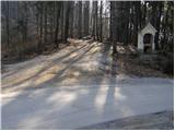
a) We drive into Laško, and then at the traffic light intersection we drive in the direction of Spodnja Rečica. Further on, Laško ends and we arrive at Spodnja Rečica, and later also at Zgornja Rečica, but we continue driving. When the main road turns right towards Šmohor, we go slightly left onto a side road, along which there are signs for Brezno. For a short time, we continue driving through the valley, and then the road turns sharply to the left and crosses onto the northern slopes of Baba, through which we ascend diagonally past individual homesteads. When we return to the forest, we quickly reach the Zavrate saddle, where we park in a suitable place. At the starting point, there is the Brunarica pri knapu pod Babo and one of the entrances to the former Barbara rov mine.
b) From the Hrastnik - Rimske Toplice road, we turn left (or right from the direction of Rimske Toplice) towards the settlements of Sedraž and Trnovo. At the next intersection, we go slightly left towards Brezno, and then we start noticeably ascending towards the Zavrate saddle. When we reach the mentioned saddle, we park in a suitable place.
Route description:
From the Zavrate saddle, we head west on a footpath towards Baba and Ostri vrh (east of the saddle, a path leads to Govško brdo). The path at first leads past a log cabin "pri knapu pod Babo", and then continues on at first a gentle cart track. After a few minutes of easy walking, we notice a signpost directing us left onto a well-trodden footpath that begins to ascend more steeply. Higher up, the path becomes so steep that fixed safety gear is available for assistance, though not necessary in dry conditions (in wet or snowy conditions, there is a significant risk of slipping). We then follow this quite steep and well-maintained path to the peak of Baba, from where a beautiful view opens up.
From the top of Baba, we continue along a marked ridge path, which first descends and then begins to ascend along the edge of quite steep slopes, dangerous for slipping in wet conditions. The path, which occasionally ascends quite steeply, brings us to Ostri vrh after approximately 40 minutes of walking from Baba.
Zavrate - Baba 0:40, Baba - Ostri vrh 0:40.

Photos:
 1
1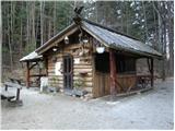 2
2 3
3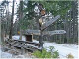 4
4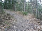 5
5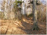 6
6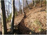 7
7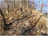 8
8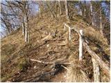 9
9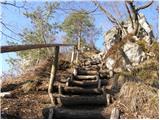 10
10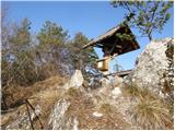 11
11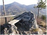 12
12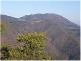 13
13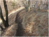 14
14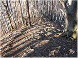 15
15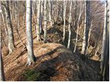 16
16 17
17 18
18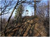 19
19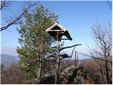 20
20
Discussion about the trip Zavrate - Ostri vrh
|
| VanSims17. 04. 2010 |
The trail from Baba to Ostri vrh is easy, you just need to watch your step on that ridge path right after Baba and when descending to the saddle between the mountains, because there are some roots on the path. Otherwise one of the nicer trails I've hiked.
|
|
|
|
| brinta30. 01. 2012 |
Hiked the trail yesterday, and it was wonderful despite the poor weather. Praise to PD Laško, the trail is excellently marked.
|
|
|
|
| Enka20. 05. 2012 |
Apparently I don't know my way around very well  , as I couldn't find the Zavrate pass today via the path from Laškega. Past the Plečnik church I reached a farm where the asphalt ends, above and below the farm it turns into a rather bad forest road, which didn't match this description nor the picture (of the asphalt) road at Zavratih (picture 1). And I also didn't know whether to take the right or left forest road... Since I didn't find a living soul all the way to the "valley" and didn't feel like going back down the steep road, I continued with my errands. Now after browsing the net and looking at the map, I conclude that one of the two forest roads was indeed the right one. The upper (right) one? Can someone explain this a bit? And one more question - isn't access from Hrastnik actually more recommended (better road)? , as I couldn't find the Zavrate pass today via the path from Laškega. Past the Plečnik church I reached a farm where the asphalt ends, above and below the farm it turns into a rather bad forest road, which didn't match this description nor the picture (of the asphalt) road at Zavratih (picture 1). And I also didn't know whether to take the right or left forest road... Since I didn't find a living soul all the way to the "valley" and didn't feel like going back down the steep road, I continued with my errands. Now after browsing the net and looking at the map, I conclude that one of the two forest roads was indeed the right one. The upper (right) one? Can someone explain this a bit? And one more question - isn't access from Hrastnik actually more recommended (better road)?
|
|
|
|
| VanSims14. 06. 2013 |
The path from Hrastnik is mainly shorter from the junction off the main road. A couple of turns (a bit steep) and we're already at Zavrate.
|
|
|
|
| Enka14. 06. 2013 |
Thanks VanSims, I was just thinking that I'll have to go check those parts again :-).
|
|
|
|
| docepe214. 03. 2015 |
Somewhere approximately in the middle of the path from Babe to Ostri vrh, a well-trodden unmarked path joins from the left. Exactly there, there are signs on the tree for directions to Babe and Ostri vrh.
Can someone tell me where this path comes from, since obviously people use it?
|
|
|
|
| Mark024. 03. 2024 14:12:23 |
Yesterday I walked this path; nice and just right to stretch the legs. Unfortunately on both summits (Na Babi and on Ostri vrh) the pillar with shelter and plaque is collapsed. I hope they fix this soon given that the log cabin and its surroundings have recently been arranged and renovated.
|
|
|
To post a comment you must log in:
If you do not yet have a username, you must first
register.