Starting point: Zavrzelno (700 m)
| Latitude/Longitude: | 46,34430°N 13,53970°E |
| |
Walking time: 4 h 45 min
Difficulty: difficult marked way
Elevation gain: 1508 m
Elevation difference along the route: 1508 m
Map: Julijske Alpe - zahodni del 1:50.000
Recommended equipment (summer): helmet
Recommended equipment (winter): helmet, ice axe, crampons
Views: 60.315
 | 8 people like this post |
Access to starting point:
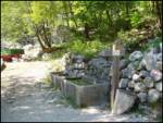
First, we drive to the center of Bovec, where we head uphill on the road passing by the church towards Kaninska vas. We follow the road further and it soon brings us to a junction, where we continue straight (the left road descends to Plužna village). The road then quickly leads us to the next junction, where we turn right towards Rombon. We continue to the spot where the road crosses the torrent. Here, near the former parking lot and the start of the described trail, there are mountaineering signposts and a spring with a water trough.
Parking warning: Parking in the immediate vicinity of the trough and in the torrent area in the Zavrzelno hamlet is no longer possible and prohibited due to private land and narrow road. Leave the car lower at one of the designated parking lots in Bovec or along the road below Kaninska vas, and walk to the trough and signposts, which extends the approach.
Route description:
From the former parking lot by the spring, markers direct us onto the footpath (watch out not to start along the cart track), which initially ascends through sparse forest, about 15 minutes higher entering dense forest through which it then ascends moderately. Further on, the path crosses several old military roads, mainly mule tracks, and after about half an hour walking from Zavrzelno hamlet leads us out of the forest onto grassy slopes. We continue to the central part of the abandoned Planina Goričica, where a hunting hut stands.
From the pasture, a view opens to the surrounding mountains, especially those south of the Bovec Basin. We continue along the lower right path towards Rombon (left to Črnelska špica), which brings us in a few easy steps to the site of the former military hospital. Today, only ruins remain of the hospital, located some 10 meters off the marked path, while the memorial plaque stands near the marked path.
Here the marked path turns left and ascends through the last forest belt on our route. Higher up, leaving the forest, we notice numerous military trenches – caverns on the right, and a cross on the opposite side of the path. The entire Rombon area is known for some of the fiercest clashes of World War I.
The path ahead ascends along a quite dilapidated mule track and leads further through the area where numerous remnants from the time of carnage in this region can be seen along the path. Higher up the path levels and a fine view of Rombon opens, with the path forking here.
We go right towards Čukla (straight is the marked path to Rombon), the summit with monument, reached in just three minutes further walking.
From Čukla we return to the last junction and follow the marked path towards Rombon. In a few minutes of easy ascent we arrive below the foot of rocky cliffs. Here the increasingly panoramic trail turns left and ascends the scree at the base of steep walls.
The fairly strenuous path ascends steep scree, then turns sharply right into the pronounced Naklo gully, exposed to falling rocks. Follows a steep ascent up the gully, where we must walk very carefully not to trigger rocks, as it can be deadly for hikers below. In early summer there is usually still snow here. Reaching higher the top of the upper, partly grassy gully section, we step onto Vrh Nakla saddle. The actual summit is right, just a few steps off the path.
At the saddle a path joins from the right from the start at Trdnjava Kluže (via Hermanova utrdba), we continue sharply left towards Rombon.
The path then rises very steeply over a short, about five meters high step, where using natural holds we climb one level higher. Great caution needed here, especially on descent! The trail then eases a bit and continues along the summit, moderately steep slope of the mountain. We follow this increasingly panoramic path to the top of this mighty and historically renowned mountain.
Due to numerous military fortifications along the path, a headlamp is recommended for inspecting them, otherwise not needed on the path itself.
Starting point - Planina Goričica 1:45, Planina Goričica - Čukla 1:15, Čukla - Naklo 1:05, Naklo - Rombon 0:40.

Photos:
 1
1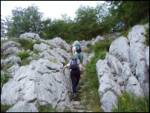 2
2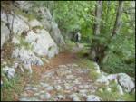 3
3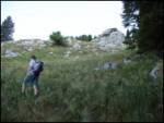 4
4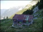 5
5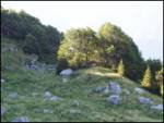 6
6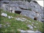 7
7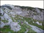 8
8 9
9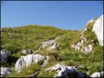 10
10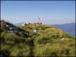 11
11 12
12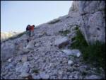 13
13 14
14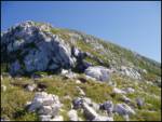 15
15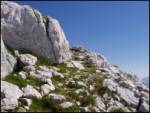 16
16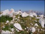 17
17
Discussion about the trip Zavrzelno - Rombon
|
| Gost1. 08. 2006 |
This is a path that requires extraordinary will and endurance, which is richly rewarded at the end with beautiful and unique views of the surrounding mountains and the mountain world in general. Without knowledge of history, it doesn't work either. At least some basic knowledge is recommended for viewing this attractive mountain.
|
|
|
|
| Gost29. 09. 2006 |
The path may be just a bit demanding, but the effort at the top in case of nice weather is rewarded a hundred times. Well, without effort you don't get anywhere in the mountains.
|
|
|
|
| Gost18. 07. 2007 |
We set off for Rombon with great trepidation, as the path was supposed to be long and demanding. To our great surprise, we found it was not at all as long and demanding as described.
Even in summer heat is not a problem if you start early, you're at the top before 10 a.m. Since we are interested in the Isonzo Front battlefields, we were a bit disappointed as we expected to see much more.
Excellent hiking tour.
|
|
|
|
| Gost18. 07. 2007 |
For fans of the Isonzo Front, I recommend the unmarked approach from the Kluže fortress.
|
|
|
|
| Gost22. 07. 2007 |
The Kluže-Rombon path is now MARKED.
|
|
|
|
| andrej76730. 07. 2007 |
"The Kluže-Rombon path is now MARKED." THAT MAKES ME  13-13 is LAW! 13-13 is LAW!
|
|
|
|
| Gost30. 07. 2007 |
What is the difficulty of the Kluže-Rombon path
|
|
|
|
| Gost31. 07. 2007 |
A headlamp comes in handy, otherwise the path is not more demanding, rather easier than the one from Bovec.
|
|
|
|
| Gost13. 08. 2007 |
Is this the path that goes right uphill from Herman fortress? What's the estimated time? 
|
|
|
|
| Gost17. 08. 2007 |
From Kluž to 1313 about one hour - mulatjera nicely marked, all the time in shade or forest. It's worth going to point 1313 itself and the first part of the path will be rewarded with a unique view of the Bovec basin. From 1313 to the junction with the path coming from Kluž the path is fully sun-exposed, partly along mulatjera, partly over scree (not scree but stones and rocks that flew over the southern slab of Veliki vrh. I wouldn't speculate on the time spent on this part. We indeed "fell into it" and focused more on objects along the path (cavern where the upper station of the cableway was located, stone steps, mule spaces, concrete water collectors, shooting trenches). Still I think two to three hours walking need to be reserved for this part. From the point where the path joins the one from Bovec the path is somewhat steeper, exposed in some places. To the top you'll need another good hour. From Kluž to the top four to five hours then! Descent awaits of course. You can return the same way, cross over Črnelska špica Lope - Prevale to the upper station of the Kanin gondola and down by gondola, or at the junction of the path from Bovec and from Kluž choose the former and descend directly to Bovec. For descent count three to four hours regardless of direction.
|
|
|
|
| _sandra_4. 09. 2011 |
3.8. we were on Rombon, the path is steep and quite demanding, at least for those with a bit less fitness 
Otherwise the view from the summit is splendid. We went back towards Kluž, where the path is somewhat more pleasant but drags on through the forest for quite a while.
|
|
|
|
| _sandra_4. 09. 2011 |
mistake, we were at the summit on 3.9.2011, not 3.8.
|
|
|
|
| Jonny_12. 09. 2011 |
I was on Rombon for the first time some time ago, still as a child. After about 17 years I wanted to go again, as this path impressed me the most among all mountains, because it is quite interesting, varied, diverse. We had wonderful weather, so the view was magnificent - to Bovec, along the Julian Alps, ...
We started from Zavrzelno. The path starts at 529 meters and not at 700 as written above at the starting point. The path rises mercilessly right away and stays like that most of the time.
We returned to Kluže. The path back drags everywhere veeeeery much, so most are in a bad mood when returning. 
For someone who has just started hiking in the mountains, this tour is not suitable.
I sent GPS tracks to the site administrators for publication, so follow when the file will be uploaded. The path from Zavrzelno was the only one missing among GPS tracks for Rombon.
HERE you can see our photos. 
|
|
|
|
| Janiel7414. 11. 2012 |
Does anyone know how the access to Zavrzelno is? Did the floods destroy anything?
|
|
|
|
| B214. 11. 2012 |
From Kanin village to the trough in Zavrzelno it's good 15 minutes on the marked path - back less than 10... The asphalt road is probably undamaged... Have a nice day!
|
|
|
|
| Janiel7414. 11. 2012 |
Thanks. So to the described starting point, I assume you can get there without a problem?
|
|
|
|
| darinka430. 05. 2015 |
Today on Rombon, the first time at all, although it had been inviting for a long time. The weather was just right for walking, no heat, because the last part to the top drags on. And what a crowd there was at the top, a group of Czechs came from Kluž, descended to Zavrzelno.
|
|
|
|
| sebaseba2. 10. 2015 |
Today up there. No snow. The path is well marked, but on many sections (especially on the approach) the marks are more or less faded.
|
|
|
|
| darinka418. 06. 2018 |
If anyone is going from Zavrzelno. No snow anywhere anymore. The path is fine, except that steep scree slope where you need to watch out on the descent. And fitness is needed because the hike is quite strenuous, especially if you have the sun blazing like I did.
|
|
|
|
| darinka44. 06. 2019 |
Yesterday I walked from Zavrzelno to Rombon and back the same way. I didn't need winter gear, although there is still some snow patches on the path.
|
|
|
|
| ales505. 06. 2019 |
I was there on Sunday, hot but a couple of snow patches to cool off, met a viper on the path,
|
|
|
|
| jax5. 06. 2019 |
I would just comment on this a bit. I was also up there on Sunday, but via the path from Kluž. And yes, I looked into the gully where this path comes out. I can say that to me it doesn't seem safe at all without winter gear. Maybe it's just "a couple of patches", but to me it didn't seem so innocent at all.
|
|
|
|
| ales505. 06. 2019 |
one path is from below in the direction of Bc, with a view downwards, there without winter gear it really is not safe, especially when the snow is melting, there it really is not safe, there are holes and you can slip and without signal no living soul will find you.
|
|
|
|
| ales505. 06. 2019 |
it was hot and the snow was a real refreshment,
|
|
|
|
| SuperHribolazka26. 05. 2020 |
Ascent 24.5.2020 from Zavrzelno. Still a small snow patch in the gully, which is extremely steep and requires maximum concentration and cautious steps. Towards Kluže no snow. I would suggest to the path markers to also arrange the path along the traces of the Soča front on the southern slope of Rombon from the top towards Čukla.
|
|
|
|
| darinka420. 03. 2022 19:28:05 |
Today I decided on the winter variant from Zavrzelno. No one else was on the trail. Not even at the summit. The weather was really nice. I didn't know the conditions. But there were no problems.
|
|
|
|
| BT8820. 03. 2022 22:36:40 |
Is Naku still nicely filled?
|
|
|
|
| darinka421. 03. 2022 06:29:39 |
Yes, Naku is currently nicely filled. Also down below. There were footprints in the snow. Probably some time ago, when the snow was wind-packed there. Yesterday at least back there it held well.
|
|
|
|
| BT8821. 03. 2022 10:25:14 |
|
|
|
|
| padez21. 03. 2022 10:55:52 |
I don't know where this Naku is, but I assume it's the Naklo gully. I was there last week. The Naklo gully is nicely filled and icy. Of course you go through without problems, but only with crampons and ice axe. There the ice and later hard snow will hold until the end of May, or longer, especially in the upper narrow part. A possible slip ends on the scree...
.
|
|
|
|
| BT8821. 03. 2022 11:03:10 |
Thanks. I know, I went up in January. I'm asking about the skiing  but I didn't ski down because it was literally concrete right from the hut onwards. but I didn't ski down because it was literally concrete right from the hut onwards.
|
|
|
|
| andrejf20. 07. 2022 17:56:20 |
This Sunday we headed to Rombon, after a good 5 hours with breaks, we were already thrilled by the exceptional views. I would add that parking is no longer allowed at the parking lot mentioned in the description, the owners have clearly marked it. We chose the ascent from Kaninska vas, a bit lower, where there is a sign with marking and inscription Čukla, Rombon.
|
|
|
|
| darinka410. 08. 2022 23:02:42 |
Interesting tour today. Part of the path from Zavrzelno. Then at the junction before planina Goričica, we turn right into pathless terrain. Inspection of caverns. Probably few go there. We had help from two Bovci locals on the route of this pathless part. But we went too high and decided for the steepness directly over the grass. Then we found a path somewhere at 1750m that goes from Kluž and followed it to the top. Warm at the top. No wind. Descended into the Naklo gully to the starting point in Zavrzelno.
|
|
|
|
| pclop31. 10. 2022 14:03:11 |
On the map posted here, the marked path is not the real one. If someone looks at the path on this map (similar on Google) and takes shortcuts, some creativity is needed to reach Goričica. The marked path actually avoids "Na vrh robu" and "Utarji" and goes much further right and reaches Goričica from below on the southern side, not the western.
|
|
|
|
| padez31. 10. 2022 16:49:54 |
Yes, pclop. Where the marked path is drawn on the published map, in reality it's a nice mulattiera and unlike the marked mountain path it's much longer, but much gentler.
|
|
|
|
| damjan8615. 07. 2023 09:59:53 |
Hi!
On 2.7, during the ascent to Rombon from the direction of Bovec (Zavrzelno) at an altitude between 1900-2000 m, where the path rises to the roof of Rombon, I found Outdoor Expert Trekker QL poles. They have double extension. Whoever misses them should report to ZS.
Otherwise, if you're heading to Rombon in this direction in the morning, I strongly recommend protecting your boots, as the path goes through high grass with a lot of dew. I had good boots, but at the top my socks were quite wet.
Best regards
|
|
|
|
| darinka429. 08. 2024 22:32:53 |
Quite a long full-day tour today. A bit different. Off-trail. From Zavrzelno to elevation 1313. Then for a while on the marked trail from Kluž. Soon we turn off-trail. And we reach under the summit the path coming from Kanin. Descent to the saddle, where we don't go into the Naklo gully, but traverse the unnamed summit. In the lower part there is also a fixed rope, which is quite useful. We continue past Mrtvaške glave and near Krljišče we descend to the lower path towards Goričica.
|
|
|
|
| darinka416. 09. 2025 11:03:42 |
15.09.2025. Although the weather forecast was somewhat promising, Rombon was in grayness. But the tour is still quite nice. Part of the path on marked trail, the rest pathless. And also visit to caverns there where we didn't go last time (Dead Skulls is what that part is called). No rain though, although it rained after 5am when driving towards Bovec.
|
|
|
To post a comment you must log in:
If you do not yet have a username, you must first
register.