ŽP Buzet - Špičasti vrh (pri Žbevnici) (položna pot)
Starting point: ŽP Buzet (380 m)
Starting point Lat/Lon: 45.42629°N 13.98507°E 
Path name: položna pot
Time of walking: 3 h 40 min
Difficulty: easy marked way
Difficulty of skiing: no data
Altitude difference: 577 m
Altitude difference (by path): 675 m
Map:
Access to starting point:
a) Leave the Primorska motorway at the Črni Kal exit and continue on the old road towards the sea, but we drive on it only to the next somewhat larger intersection, where we turn left towards the Sočerga border crossing. Drive on the mentioned road past the settlement of Kubed to the village of Gračišče, where at the intersection turn left towards Rakitovec, Movraž and Smokvica. Drive through Smokvica and Movraž to the next intersection, where turn right towards the Rakitovec border crossing. You can also reach here via Zazid. Upon arriving in Croatia, you reach a wider road coming from Buzet; continue right towards Buzet. The road leads over the edge to a sharp bend, from which a road branches off towards the Buzet Railway Station. Head onto the narrower road that leads through the village and soon arrive at the parking lot at the Buzet Railway Station.
b) Leave the Primorska motorway at the Črni Kal exit and continue on the old road towards the sea, but we drive on it only to the next somewhat larger intersection, where we turn left towards the Sočerga border crossing. Drive through Kubed and Sočerga to the Sočerga border crossing, where you cross into Croatia. Drive to Buzet. At the first two roundabouts go straight, at the third roundabout turn left towards Brest. Drive through Sveti Martin, then the road makes a bend. At the second sharp bend, a road branches off towards the Buzet Railway Station. Head onto the narrower road that leads through the village and soon arrive at the parking lot at the Buzet Railway Station.
Path description:
From the starting point, we go back along the road to the intersection, where signposts direct us across the railway track. Soon a wide path branches off to the left from the road. We take this path, which initially crosses the slope of the nearby peak Kuk. Soon it starts to zigzag and becomes somewhat steeper. After 20 minutes of walking from the road, we arrive over the edge, where there is a junction. Continue straight towards Žbevnica. Left to Kuk and right to Pilj. The path gently descends through the forest. We reach a gravel road, which we follow straight. After about 5 minutes of walking, signs direct us right onto the path. The path soon returns to the track, which we follow to the right. We follow the track through the forest to a meadow, where there is a junction. Continue straight (markings are rarer here), then it turns right and returns to the track. We arrive in Slum, where there is a junction. Right leads to Rašpor and further to Gomila and Orljak, but we continue left and in a few steps we are at Sveti Matej, next to which stands a mighty linden tree.
From the church, continue along the road to the next intersection, where markings direct us right. Initially we walk on an asphalt road, then it turns into a track that first gently descends to a small meadow. Then the path steeply ascends for a short time, then turns left and traverses. To the left along the path there is a large sinkhole. After about 10 minutes of traversing with short gentle descents, the path turns right. The steep path makes short zigzags and crosses the edge onto the plateau. Through a pine forest and past an animal feeding station, we reach an asphalt road leading to Brest. We just cross the road and the path here is somewhat less trodden. Alternatively, we can continue along the road. The path returns to the road, which we follow left. The road passes a chapel, behind it the path cuts the bend. From the road bend, markings direct us right onto the track. Continue past a stone building and into a strip of forest. Soon we reach the bocce court and parking lot in Brest. Signs direct us onto a wide and initially level path into the forest. The path leads past a water reservoir and soon also a concrete structure and becomes steep. Traverse right and after a few minutes reach a technically easy, short steep rocky section. The path is well laid out, just be careful not to slip. Beyond the rocky section, we arrive at the Žbevnica Mountain Hut. From the hut, continue to the track, which we follow left. Straight ahead is the steep path to Žbevnica. The track steeply ascends for a short time, then levels out. After about 15 minutes of mostly flat walking along the track, markings direct us right onto the meadow and later back into the forest. Straight ahead towards Kavčič and Stargata. The track narrows and begins to steeply ascend through mixed forest. Soon the forest starts to thin. After about 15 minutes, we finally emerge from the forest onto the grassy slopes of Muzari. The path ascends to the saddle between an unnamed peak and Žbevnica, where there is a junction; continue left towards Špičasti vrh. Right to Žbevnica 5 minutes. Ascend along the ridge over the unnamed peak, behind it the path descends again. The marked path follows strictly along the ridge, where the path is barely traceable, but the track goes slightly off the ridge and is well traceable. The path begins to ascend and soon we reach Muzari, from where a nice view opens in all directions.
Continue along the grassy ridge, which begins to descend. The path then levels out and we reach a junction, where we turn onto the trail. Straight ahead the path to Golič, which bypasses Špičasti vrh. The path ascends along the scenic grassy slope and in 5 minutes we are at Špičasti vrh.
Description and photos refer to the condition in November 2024 and 2025.
Pictures:
 1
1 2
2 3
3 4
4 5
5 6
6 7
7 8
8 9
9 10
10 11
11 12
12 13
13 14
14 15
15 16
16 17
17 18
18 19
19 20
20 21
21 22
22 23
23 24
24 25
25 26
26 27
27 28
28 29
29 30
30 31
31 32
32 33
33 34
34 35
35 36
36 37
37 38
38 39
39 40
40 41
41 42
42 43
43 44
44 45
45 46
46 47
47 48
48 49
49 50
50 51
51 52
52 53
53 54
54 55
55 56
56 57
57 58
58 59
59 60
60 61
61 62
62 63
63 64
64 65
65 66
66 67
67 68
68 69
69 70
70 71
71 72
72 73
73 74
74 75
75 76
76 77
77 78
78 79
79 80
80 81
81 82
82 83
83 84
84 85
85 86
86 87
87 88
88 89
89 90
90 91
91 92
92 93
93 94
94 95
95 96
96 97
97 98
98 99
99 100
100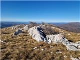 101
101 102
102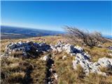 103
103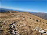 104
104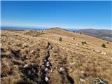 105
105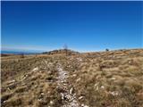 106
106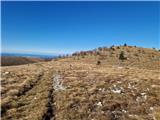 107
107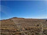 108
108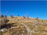 109
109 110
110 111
111 112
112 113
113