Gorica pri Slivnici - Rifnik
Starting point: Gorica pri Slivnici (276 m)
Starting point Lat/Lon: 46.1879°N 15.42985°E 
Time of walking: 1 h 15 min
Difficulty: easy marked way
Difficulty of skiing: no data
Altitude difference: 292 m
Altitude difference (by path): 350 m
Map:
Access to starting point:
We leave the Štajerska highway at the Dramlje exit, then follow the signs for Šentjur. From the center of Šentjur, we continue briefly towards the settlement of Šmarje pri Jelšah, but soon turn right onto the road towards Podsreda and Planina pri Sevnici. When Šentjur ends, we soon turn left from the main road in the direction of Podsreda, Kozje, and Gorica pri Slivnici. When we arrive at the settlement of Gorica pri Slivnici, we park in the parking lot by the bus stop, where we also notice hiking signposts.
Path description:
From the starting point, we head in the direction of signs for Gaj and Rifnik, where we first carefully cross the main road at the pedestrian crossing and continue right to a nearby crossroad, where blazes direct us left onto an ascending sidewalk, along which we arrive at the primary school Slivnica pri Celju in a few minutes. Here, the marked path turns right and continues along the asphalt road, on which we quickly arrive at the nearby church of St. Urban.
Behind the church, the road gradually passes onto the slopes of the hill Gaj, over which we diagonally ascend towards the left to a marked crossroad by some houses.
We continue slightly left (right Gaj) and by the houses start moderately descending. When the hamlet ends, some descent follows, then an easy ascent to a smaller crossroad, where we continue straight. The path ahead leads us past a few more houses and a chapel, then we descend to the bridge over Voglajna, after which we continue right.
Here we carefully cross the main road and continue to a smaller hamlet, where signs for Rifnik direct us onto a path leading among houses, and we bypass the house on the right on its upper side. Next follows a diagonal ascent on a cart track; the cart track higher up turns left and brings us to a solitary house, where the path turns back towards the right. We continue walking on the cart track, and when we reach a poorer road before the next house, we go sharply left. Next follows some crossing towards the left, where a nice view opens up from the grassy parts. The path ahead leads us past an abandoned house; from a smaller crossing, where we reach a macadam road, we go left, at first slightly downwards. When we leave the forest a little further on, we reach an asphalt road, which we follow right upwards (straight downwards Resevna).
Next follows a few minutes of ascent on the asphalt road, then we go right from a smaller crossroad, where the path leads us by a pasture. On the other side of the pasture, we ascend into the forest, and in the forest, we continue left on a slightly longer marked path. Next follows a short, easy descent, and we join the path from Šentjur.
Here we go right, and in a few minutes of further walking, we arrive at a viewpoint and an inscription box on Rifnik, with the highest point located a minute further by the renovated ruins of an archaeological site.
Description and pictures refer to the condition in November 2023.
Pictures:
 1
1 2
2 3
3 4
4 5
5 6
6 7
7 8
8 9
9 10
10 11
11 12
12 13
13 14
14 15
15 16
16 17
17 18
18 19
19 20
20 21
21 22
22 23
23 24
24 25
25 26
26 27
27 28
28 29
29 30
30 31
31 32
32 33
33 34
34 35
35 36
36 37
37 38
38 39
39 40
40 41
41 42
42 43
43 44
44 45
45 46
46 47
47 48
48 49
49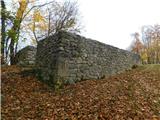 50
50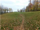 51
51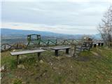 52
52 53
53 54
54 55
55 56
56