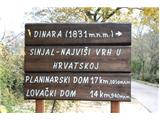
Dinara (highest peak of Croatia)
|
| Tadej3. 06. 2008 09:34:11 |
On Friday I set off from Suho polje, where there's a larger parking lot (approx. 15km above Knin) to Dinara (1831m). 10km of road to Suho polje is in very poor condition, the next 7 to Brezovac hut (1050m) even worse. If heading on this route I recommend taking a bike.
Tour length under 5 hours, 1h 40min to hut and 2h 40min from hut to summit. Path is easy and well marked. LP Tadej
|
|
|
|
| Tadej3. 06. 2008 09:58:37 |
Dinara on Friday 30.5.2008
Starting point: Suho polje 820m
Regards Tadej
|
|
|
|
| iva3. 06. 2008 22:32:52 |
How to get to Brezovac..
Exit from Knin at the junction right to Sinj (right Kovačić, left Strmica). Turn left towards Strmica 1.6 km to s.Guge, then right sign and marking Dinara very little asphalt then over small bridge and sharp hairpin right onto gravel road leading to Dinara.
Continue on gravel road (10 km) to location Markov grob (Suho polje). You can get there by personal car. Park the vehicle in that wide area. There is also a footpath to Markov grob. The footpath starts at the bridge in Gugama where gravel goes left and footpath right. Rough estimate is 2:30 hours to Markov grob.
At location Markov grob there is a crossroads. You will recognize the place by the actual tombstone and marking signpost for pedestrians on which it says Suho Polje, then arrow and distance to trail for Brezovac and Dinara summit. Left you can go by off-road vehicle on very bad gravel road (7 km) to Brezovac.
Straight ahead there is also a road for off-road vehicles, which is actually the marked pedestrian path to Planinarska kuća Brezovac. The path is marked at the beginning with a marking signpost and later joins the left gravel road for off-road vehicles.
From Markov grob (Suho polje) to Brezovac a little less than 2 hours walk (as written on signpost). Seems to me it can be faster. All on gravel road following markings. Markings are good.
From the hut there is a marked trail to Dinara summit about 3 hours ascent.
Above the Brezovac hut, which is fully equipped, the path climbs gently through forest to pasture Duler, and from it to Samar. From Samar uphill on trail past vertical rock steeply, then another 20' somewhat easier, towards the end through junipers, to Sinjal. Unlike the path from Glavaš views are open and ascent not so tiring.
 1 1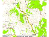 2 2
|
|
|
|
| milanmilan14. 08. 2013 23:41:24 |
Hello!
As a busy hiker last weekend after two days of swimming in Pakoštane I went hiking to the highest peak of Croatia - Dinara. On Sunday, 11.08.2013 I drove by car to the parking at Suho polje. From there I enjoyed 1.5 hours walking in beautiful nature to the mountain hut Brezovac. There a friendly lady greeted me from the bench in front of the hut, where there were a few more people. She kindly invited me "come sit with us". Since it was 4:45 pm I decided to go straight to the Dinara summit. For safety I asked her if there is possibility of overnight in the hut. The really friendly lady said "I don't know, here's the president ask him". He told me it's no problem. The lady still insisted I stay a bit with them so I replied "I'm rushing up, then we'll sit together".
After that I enjoyed walking, beautiful panorama... After 1.5 hours I reached the cross where I took a timer photo since no one was up there even though it was Sunday afternoon...
When I had rested and started back (don't know why) suddenly I had a bad feeling so I even jogged a bit at times. I returned to the hut at 7:40. Immediately noticed no vehicles at the mountain hut. Believing that there would be on the locked iron door the president's phone number with message he went for supplies and will return at... there was nothing. I immediately decided to go on the 1.5 hour tour knowing night would catch me before the car. Started running right away. After some time first problems began. Twice two dogs chased me that shepherds have for guarding sheep. At the last station where sheep were already in the pen suddenly four dogs ran at me barking. One was terribly big (probably karst shepherd dog) and didn't let me pass further. It was 1.5 m from me, growling and showing teeth. I really got scared. Started yelling for help, at first no one heard. Later the shepherd came from the house and started slowly calling the dogs. The attacking karst shepherd wouldn't obey the owner and wouldn't calm down. After a few minutes it started returning to the house.
Night was close so I started running again (with backpack...) and reached the car at half eight when it was already dark. I prepared a flashlight to chase possible wild animal if needed...
If that was really the president of the mountaineering society (hut was open until 4:45) I call on all who elected him to think if he is really suitable for this position.
President (or whoever was at Brezovac hut then) I invite you to (if you haven't been to Triglav yet) come to Slovenia, I'll guide you to Triglav and you can stay at my place for three days free...
Milan SLO
|
|
|
|
| bos31. 07. 2022 09:43:12 |
Then I went from the other side, as a "bonus trip" for the end of Croatian mountain trail.
From the sea I drive to Knin and further to Kijev, where signs direct you to Glavaš, almost to the starting point at Planinska koča Glavaš (container) is asphalt road, so I think better starting point than Suho polje where you drive long on gravel. Then past fortress Glavaš towards Pl. shelter Martinova košara and past chapel Sv. Ilija first to summit Jančija glavica 1585 m and then to Croatian summit. Descend on path past Pl. shelter Drago Grubać.
I read about 4 h for direct ascent, at starting point it says 5 h, but I used 3 h for my ascent path.
In the morning at starting point I wake Austrians who were tenting, at summit enjoy solitude who were tenting, at summit enjoy solitude , meet some people on descent, some just starting when I'm almost back at car, sun burning , meet some people on descent, some just starting when I'm almost back at car, sun burning . At starting point Austrian, Croatian, Slovak, Czech, Polish, Hungarian, ... license plates, while Slovene already driving to sea and lunch. . At starting point Austrian, Croatian, Slovak, Czech, Polish, Hungarian, ... license plates, while Slovene already driving to sea and lunch.
Dinara, I'll come again.
 1 1 2 2 3 3 4 4 5 5 6 6 7 7 8 8 9 9 10 10 11 11 12 12 13 13 14 14 15 15 16 16 17 17 18 18 19 19 20 20 21 21 22 22 you can see from afar") 23 23 24 24 25 25 26 26 27 27 28 28 29 29 30 30 31 31 32 32 33 33 34 34 35 35
| (+9) |  | |
|
|
|
|
| geppo31. 07. 2022 12:56:18 |
Thanks for all ideas and tips!!
Regards
And of course for further ones
Regards
| (+2) | | |
|
|
|
|
| bos31. 07. 2022 14:32:13 |
I'll keep trying if it helps anyone ...
| (+3) | | |
|
|
|
|
| Janezs16. 09. 2022 13:27:11 |
Also with Romana we chose this path, marked 5 h. With the difference that we kept to the left direction. Higher up we noticed that years ago fire raged towards summit, so path nicely "cleared of pines". On descent in the other direction, we said fire left work for markers. On descent Romana jumped high over snake with a scream. For loop 5.20 h.
| (+2) | | |
|
|
|
|
| bos30. 06. 2023 21:19:18 |
During sea holiday I used one day for via ferrata "Dinaridi", longest ferrata in Croatia.
Actually consists of two ferratas, as I saw online, so to Dinaridi bivouac is "Devet tornjeva" ferrata with some emergency exits, from bivouac to Ošljak summit "Vjetar s Dinare". Difficulty B-D, though no signs with ferrata and ratings of whole path or details.
After ferrata exit continued to highest Croatian peak, enjoyed solitude there as before on ferrata.
For descent used path I spotted last year on descent to Glavaš, at start somewhat marked with stakes, then no longer marked path, more feel than see it, basically just straight down , of course possible to descend other way through couloir with cable. As I saw, very crumbly, but not for my descent. , of course possible to descend other way through couloir with cable. As I saw, very crumbly, but not for my descent.
Spent another interesting day on Dinara, becoming more familiar.
 1 1 2 2 3 3 4 4 5 5 6 6 7 7 8 8 9 9 10 10 11 11 12 12 13 13 14 14 15 15 16 16 17 17 18 18 19 19 20 20 21 21 22 22 23 23 24 24 25 25 26 26 27 27 28 28 29 29 30 30 31 31 32 32 33 33 34 34 35 35 36 36 37 37 38 38 39 39 40 40 41 41 42 42 43 43 44 44 45 45 46 46 47 47 48 48 49 49 50 50 51 51 52 52 53 53 54 54 55 55
| (+5) | | |
|
|
|
|
| tgrahe115. 03. 2026 19:21:08 |
What's the current situation on Dinara? How much snow is on the top? Is it accessible with small crampons and without ice axes? Is the ascent safe?
Maybe a question also for those who have been to the top in the past in March, what was it like?
Thanks for the answers.
|
|
|
|
| Andrej8026. 04. 2026 21:46:10 |
Yesterday we decided to conquer the highest peak in Croatia. We went up via the Dinaridi via ferrata, which with its 1700m length and 700m elevation gain is recorded as the longest via ferrata in Croatia. I haven't come across a longer one in Slovenia either. The difficulty of the via ferrata is B,C,D. Otherwise, the via ferrata is very well routed and safe. Apparently, they don't have all the permits for its existence, so the state inspectorate is supposed to order its complete removal, but for now it still stands.
Total to the highest peak of Croatia and back: 1600m elevation gain, about 23km and 10h of walking. Starting point near the village Ercegovci / Kijevo. To bivouac Bili Cvitak along a poor macadam road 1h walk, to the via ferrata entrance another 0.5h. The via ferrata starts at 1000m altitude. In the middle of the via ferrata at 1260m altitude, there's a nice bivouac Dinaridi built on a ledge. The via ferrata reaches the top of the wall at 1650m. Nearby is the poorly maintained shelter Drago Grubać. From the shelter we headed to the highest peak Sinjal / Dinara (1831m). We took a path marked only with snow stakes, but it's well traceable and we needed 1h for that path. From the car to the summit about 5.5h total with breaks. Back to the shelter we returned via a parallel path marked with faded blazes. We descended to the valley into the village Glavaš and then by road back to the car. The path to Glavaš is well marked but quite long. One descent path from the via ferrata is through a gully that branches off soon from the path from the shelter to the summit. It's also marked with a sign, but they say it's crumbly. Another descent path to bivouac Bili Cvitak branches off from the path to Glavaš at about 1270m altitude. It's marked with a sign, and further on it should be traceable. No more anti-personnel mines.
| (+9) | | |
|
|
|
|
| garmont27. 04. 2026 16:45:26 |
Congratulations
Quite strenuous for one day 
|
|
|
|
| Andrej8028. 04. 2026 18:58:58 |
Thanks 😉
Considering that we went from home there and back on the same day, which took 7h of driving, we had quite a lot, yeah 😃
|
|
|
|
| bongo29. 04. 2026 17:14:38 |
Nice description, apparently you can also go through the couloir without issues, although it's quite wrecked.
Why do everything in one day when there are so many comfortable overnight stays and culinary delights nearby?
|
|
|
|
| Andrej801. 05. 2026 14:19:28 |
Yes, one of our team had obligations the next day. So we decided for one day, otherwise we would have postponed it again indefinitely. We also visited the source of the Cetina and ate in Knin.
Regarding the highest peak of Croatia, I'm a bit surprised by the low number of visitors. That day, despite the clear and warm Saturday, there were about 20 people on the summit. More than half of us came via the via ferrata. But I think the mountain has great potential. There are many paths, the landscape is wonderful, the views are magnificent. If we add the attractions in the surroundings, we must visit it.
| (+2) | | |
|
|
|
You must log in to post a comment:
If you do not yet have a username, you must first
register.