|
| IgorZlodej8. 07. 2015 15:44:07 |
We left Koča Galassi at 5 o'clock and while hiking to Škrbina Piccola we admired the awakening of a new day.
We didn't wait for the sunrise and immediately turned into the cirque, which we quickly crossed and turned into the rocks below "la Bala". The system of unprotected ledges (in the ascent description of the book Dolomiti sanjske gore) mentions fixed cables and pegs, which were never there. At the beginning of Last we had a short break, then onwards. Up to the smaller notch there were no peculiarities. There it started. Rocks broken and partially scattered, passage enabled only by a lone rock wedged in the notch. It seemed quite unstable to me at first, but the construction expert assessed it as stable enough and we crossed. Right on the other side a short and smooth chimney, which was of course already known, but there too everything was cracked, so great caution was needed.
The central part of Last was increasingly cluttered, broken, with large rocks in between that haven't rolled into the valley yet. At height around 3000 m we ended the ascent, as continuing would be extremely dangerous, since rocks occasionally crumbled from under the summit.
Proper assessment of conditions and prudence is crucial in the mountains. Simply have to be satisfied with what's achieved and we achieved a lot.
We descended extremely carefully, as everything was moving under our feet. Far below on green meadows we had breakfast and went to the hut, where we reported on conditions on the mountain and said goodbye to the staff.
Path through Val d'Oten valley is nice, lower part was very hot, good thing there's Alpini hut in between wink emoticon.
Link to: http://www.gore-ljudje.net/novosti/119922/ and http://www.gore-ljudje.net/novosti/38245/
 1 1 2 2 3 3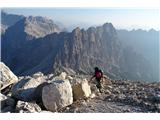 4 4 5 5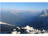 6 6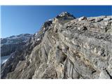 7 7 8 8 9 9 10 10 11 11 12 12 13 13 14 14
| (+8) |  | |
|
|
|
|
| mirank8. 07. 2015 23:38:54 |
Oh hi, we also had this planned, but I called the hut on Thursday and they advised against it. Description was exactly as you describe. Our intention was to do the whole thing in one day, but since you've done it before I'm interested in your opinion on such a one-day tour.
Thanks for the reply and safe steps
Miran
|
|
|
|
| IgorZlodej9. 07. 2015 07:56:36 |
For fast ones no problem, but via Scoter-Palatini hut, ascent there rated around 7-8 hours too. Possible of course from Capanna Alpina if road drivable to there, similar times.
| (+1) | | |
|
|
|
|
| pikpok22. 05. 2016 09:09:48 |
Yesterday tried with friend on king of Dolomites via Arnaldi-Menini gullies. Before two we were already in San Vito di Cadore but first surprise: fence marks works and unclear if transport to Scotter hut allowed or not. To not toil in vain we decide and leave car in village (on return learned path was open), thus extending tour by ca 1h (400-500m height). First part of path fast, snow avoidable practically to Galassi hut. From hut a bit on right. From here conditions quite varied. To entry first gully snow crusty but mostly doesn't hold human weight (path now trodden). Such conditions slowed us a lot, and in gully even worse: snow not settled and sinks to knees. Treading in 55° gully real torment and so we reach just below Forcella Menini when clock already 8:30. Snow where sun was got wet fast and from slopes above gullies started falling stones, snow and ice, so and since quite tired, decide better turn back (to summit only ca 250m left  ). Not even sure if normale via passable for descent or have to return same way (which two hours later really very dangerous). Descent in gully very fast, path on glacier completely soaked. Three guys also tried Oppel gully but they turned too because too much sinking and falling from slopes. ). Not even sure if normale via passable for descent or have to return same way (which two hours later really very dangerous). Descent in gully very fast, path on glacier completely soaked. Three guys also tried Oppel gully but they turned too because too much sinking and falling from slopes.
| (+6) | | |
|
|
|
|
| matic46. 08. 2016 11:10:27 |
The Galassi hut keeper told me that as far as he knows nobody has been to the summit via normale this year yet.
| (+1) | | |
|
|
|
|
| pohodnik33314. 09. 2023 21:02:25 |
Ascent on 10.9.2023, Sunday.
There were many more people than expected. Consequently, stones were flying again and again. Especially the first part, when the climbing part starts from the saddle and scree, extra care is needed for stones there.
After the first climbing part it is easier, some mildly climbing sections still in between. On the upper Last part it tightened up. Very steep, lots of scree, stressful. On these slabs you think what if you make one wrong step and slip, no handholds.
Then the last climbing section as described. On the harder section very old cable in bad condition and rope. Soon the summit follows.
View ok, unfortunately this time no Slovenian mountains visible in the E direction.
Some orientation loops, especially on descent. Sometimes trodden then it stops, some more marks wouldn't hurt. Without prior climbing experience personally wouldn't have "balls" to go on such a mountain.
Near the saddle at the end of descent from the "King of Dolomites" waited another real king of this mountain, huge ibex.
 1 1 2 2 3 3 4 4 5 5 6 6 7 7 8 8 9 9 10 10 11 11 12 12 13 13 14 14 15 15 16 16 17 17 18 18 19 19
| (+8) | | |
|
|
|
|
| Trobec14. 09. 2023 23:52:12 |
Interesting, from our Alps Antelao was distinguishable  Anyway really Saturday better than Sunday. Anyway really Saturday better than Sunday.
|
|
|
|
| pohodnik33315. 09. 2023 00:27:05 |
On this picture are Cima del Preti and Durrano on the far right. On the left at least Jof di Montasio (Montaž) should be visible, but it's not. Right after the lake around Pieve di Cadore peaks are still visible - one is Cridula. Then worse and worse.
Already Clapsavon and Bivera (far left) are barely visible. Back there behind those two Triglav should be somewhere in the distance as far as I know. But true, it was during the day not morning.
 1 1
| (+2) | | |
|
|
|
|
| Trobec15. 09. 2023 22:11:35 |
Morning, yes... last time I looked that way around 10 a.m.... then Kanin covered everything 
|
|
|
|
| pohodnik33315. 09. 2023 22:39:49 |
Thanks palček plezalček.
|
|
|
|
| mirank21. 09. 2024 15:20:43 |
Very nice, as always, your group. By the way, Col de chi da Os probably means that ridge where the hut belongs to the Ossi family, that's how the owners are spelled. A little story from the hut: when we were there after dinner we were left without dessert – the landlady strangely apologized. Well, the next day after returning from the tour we chatted with nana, who helps in the kitchen, about her birthplace Ampezzo. Then screams and a bit of smoke from the kitchen. I assume the next guests were also left without strudel. It looks like due to the dry period you missed the view from Doževa ledge to the impressive 100m waterfall below right.
| (+2) | | |
|
|
|
|
| Jernej96818. 01. 2025 22:16:33 |
I know this isn't some language corner, but these famous "le laste" remind me of our "lašte", which mean rock ledges. Coincidence? Mountaineer and linguist Dr. Henrik Tuma discovered many Slovenian (Slavic) toponyms in the wider Alpine area even far from current Slovenian language area.
I myself walked these lašte on Antelao still before the rockfall, when they were still intact, but no less steep. Also Bivacco Piero Cosi (3111m), where I slept, is no more. When reading all these descriptions, I'm tempted to visit Antelao again.
| (+3) | | |
|
|
|
You must log in to post a comment:
If you do not yet have a username, you must first
register.