Great Koritnik/Trogkofel, Rosskofel
|
| Rok6. 07. 2007 00:00:00 |
Yesterday I went from the Nassfeld pass (Mokrine) to Togkofel (2279m). I went along path 403 past the Sella di Alp saddle and then on the Austrian side (Uiberlacher Steig - path 413) to the summit. On the more demanding parts of the path, ladders are installed. I descended on the Italian side (Via Ferrata Crete Rosse), this path is even a bit more demanding and more exposed than the Austrian one. Back to the Nassfeld pass I went along the path that leads over the summit of Rosskofel (2204m). The path to the summit is not demanding, but further on the path is quite exposed and unsecured. LP Rok.
|
|
|
|
| Franci H.7. 07. 2007 00:00:00 |
Is there a map of the route and to the starting point? I'm interested in this path.
|
|
|
|
| triglavski11. 10. 2009 20:10:07 |
Yesterday's forecast for FVG for Carnic Alps was excellent, so Marjeta and I didn't hesitate at all and drove to Pontebba in the morning, from there to Studeno Basso and to Lonice pass (Cason di Lanza). Sky was cloudless and washed as only after rain. From Lonice we head along sirarska path to Di Val Dolce saddle. View to High Tauern wasn't perfect, they were in mists, and snowed quite low, well even on our highest peaks it lightly dusted overnight, in next days more snow and lower. We continue along Carnic traverse eastwards, then turn left under Zottach Kopf, where both had been before, just below saddle right and along Alta Via C.A.I. Pontebbana to summit of Great Koritnik (Creta di Aip - Trogkofel). First some easy climbing, then short ferrata and easy across summit plateau to cross. Views wonderful of course, no frost yet, sun pleasantly warming, so less than an hour on top passed quickly. Followed descent westwards, first along approach path, then descent via Via normale (I.) to lower path and via 439 back to Lonice, where as much visitors as midsummer. Nice, not too long scenic tour with first autumn signs, and still summer remnants. Of course both been on this summit many times.
 1 1 2 2 3 3 4 4 5 5 6 6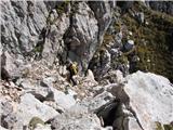 7 7 8 8 9 9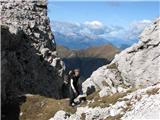 10 10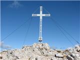 11 11 12 12 13 13 14 14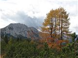 15 15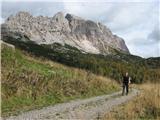 16 16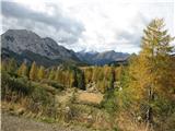 17 17 18 18 19 19
|
|
|
|
| IgorZlodej14. 06. 2010 22:15:51 |
For Veliki Koritnik the topic was already opened more than a year ago, under the name Trogkofel, which is the Austrian name for the mentioned mountain, so no sense opening new topic. Otherwise there are 4 different routes to the mountain, if counting two variants from Austrian side then 6 routes.
|
|
|
|
| bagi15. 06. 2010 06:41:48 |
Igor you are right. Overlooked, because search doesn't offer description under any name. Regarding accesses 3 from Italian side known to me, fourth I don't know, but of these Crete Rosse is best protected, although maybe harder for some.
LP Bagi
|
|
|
|
| IgorZlodej10. 08. 2010 20:24:06 |
Again to Veliki Koritnik, this time from Austrian side. With buddy we drive to Tröpolacher Alm, then go towards Rattendorf Alm. Above alm we catch path 416, then at some junction left to path (Klettersteig - Zottach koch), which at least on my map not marked, and not secured path either, but marked direction where partly climbing UIAA I. So without special effort we climb to Zottach koch, where I'm third time, short descent follows, then continue on Via Alta CAI Pontebbana, which I also hiked before, well at some places little climbing needed, protections only at ascent to summit plateau of Veliki Koritnik. Soon at summit, where quite some people this time. To west clouds greyer and when first thunder we all leave summit, we two via secured path Josef Iberlacher (cables completely new, steps old and still raining and rain accompanies us to Tröpolacher Alm. Thanks to good rain protection neither wet, nevertheless at alm we sip short one from lass. Nice circular path, where of course not to fear some descents on ascent and some ascents on descent, and also some easy climbing without protection to master.
 1 1 2 2 3 3 4 4 5 5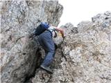 6 6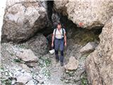 7 7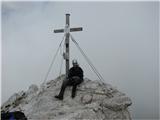 8 8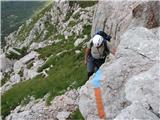 9 9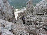 10 10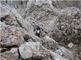 11 11 12 12 13 13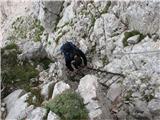 14 14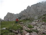 15 15 16 16 17 17 18 18
|
|
|
|
| gorski svizec21. 09. 2013 21:37:33 |
Please, can someone give info on conditions on mountains around Nassfeld. How is with snow. Which huts still open for overnight. Is hut at Rudnig alm still open and where branches path to this alm from main road? Also interested in difficulty of Uberlacher path to Trogkofel, is harder than e.g. our Bavski Grintavec? Thanks for info. lp
|
|
|
|
| VanSims22. 09. 2013 00:18:21 |
Today I drove through Gailtal valley when going to Cellon. Gartnerkofel and Trogkofel without snow.
Also no snow on Cellon itself (2238 m) and surrounding peaks.
|
|
|
|
| malimiha15. 07. 2018 07:59:47 |
8.7.2018 From Nassfeld pass to Veliki Koritnik. Up via ferrata Crete Rosse down via Uiberlacher Steig. Both paths without issues. Fixed protections in good condition.
| (+5) |  | |
|
|
|
|
| VanSims21. 09. 2020 09:50:25 |
As @bagi already wrote - wilderness! Alta Via C.A.I. Pontebba. And I too would warn about the really crumbly rock. Watch what you step on and what you grab with hands!
Unfortunately I had fog so couldn't enjoy its beauty fully (on summit warm and sun). But in my opinion more suitable for ascent than descent. This is the hardest approach to my favorite 'likalnik' above Mokrine, which looks so monolithic from there, but in background it's quite 'shattered' mountain!
Just because of low frequency, hard to find info about the path. This in Italian is the most informative I found: https://supermontifvg.com/2018/08/08/creta-di-aip-alta-via-cai-pontebba/
Access from Lonic pass (Passo di Cason di Lanza): from hut (so other side of road than to Zermula) follow signs to Sella Val Dolce (by the way can check so-called Attila's cave - good headlamp if want to go deeper), from it right to Karnic transversal (Karnischer Höhenweg), but attention: inscription on rock easy to miss. When after next junction the path starts zigzagging up need to watch for inscription 'ALTA VIA C.A.I. PONTEBBA' on rock. There take few steps left off the path (not up into rocks!) and look under feet will see first red-blue mark, then just follow, path well (at start even too much) marked to summit!
Descent: Normal route (short free climbing to I+ down), Uiberlacher steig (partly secured, exposed, otherwise unproblematic if already came via Alta Via), Crette rosse (nicest descent which I chose too, ferrata B/C, short but sweet)
Road to Lonice officially closed, but up there lots of cars, almost all of course went to neighboring Zermula. Road which is being renovated currently not in best condition, but passable, watch one section where asphalt completely gone and just in steeper incline (up with momentum, down carefully)
|
|
|
You must log in to post a comment:
If you do not yet have a username, you must first
register.