| triglavski18. 10. 2009 18:35:34 |
I was there two years ago, but this time the Lesachtal valley and approach from the north side interested me. This valley still belongs to Carinthia, but already borders East Tyrol. With my colleague we drive to Koča - Muta (Kötsach - Mauthen) and further into Lesachtal valley. The villages are idyllically arranged in Austrian style, some real tourist gems like Obertiliach, right nearby, specifically about a km or two further is Leiten village, starting point for Leitental valley. After a few km on gravel road we reach the end of the road, starting point for Filmoor Standschützenhütte. Soon we are at Stockensee lake, where wide pastures open up. We abandon the idea of crossing Creste Pitturine due to snow, so we continue to the hut, which to our surprise is open and warmly heated. We drink tea, then in sunny but cold weather continue to the border saddle, from there along southern slopes to Grosse Kinigat. For a few meters we assist ourselves with the fixed cable, then from the western ridge from where it's a stone's throw to the top. The view is good, especially on Dolomites almost "within reach", Lienz Dolomites to the north, and of course the whole pleiad of Carnic beauties to the south. Due to wind we quickly descend a bit lower, snack there, then descend via path 403 under north face of Kinigat, over Mitersattel saddle back to wide pastures and valley to starting point. We return along young Drava via Lienz and Oberdrauburg home.
 1 1 2 2 3 3 4 4 5 5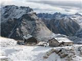 6 6 7 7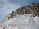 8 8 9 9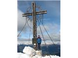 10 10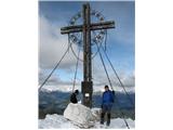 11 11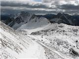 12 12 13 13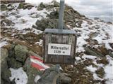 14 14 15 15 16 16 17 17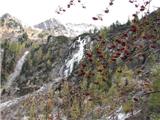 18 18
| (+1) |  | |
|
|