| atoamac16. 09. 2014 15:17:08 |
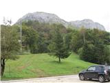
We headed to this 2025m high limestone vantage point over the Friulian plain from the Palla Barzana saddle, where we drove from Maniago through a tunnel and the nice village of Poffabro. Fog covered Lake Barcis, but we only glimpsed it higher up, same as Lake Selva on the other side of the mountain. The path is faintly marked, sometimes well hidden in tall grass, sometimes quite littered with scree, but mostly runs in a steep gully that cuts the southern slopes below the Forcella Capra notch. A rather loose fixed cable helped us over two jumps, which were - perhaps due to this year's monsoon, or maybe always like that - wet and slippery. From the notch we continued gently sporty along and on the ridge, once more with a short cable, and in a little over 3.5 hours reached the superbly panoramic summit with a red cross and logbook. Unfortunately we saw only half the view, as summer air brought fog hanging along the ridge. But that half includes the entire Friulian Dolomites, the highest peaks of the Dolomites, part of the border ridge of the Carnics, some Julians and in ideal conditions even the High Tauern. Down we enjoyed sliding on the scree. At the saddle we couldn't explain to the Italians why there were two Italian flags fluttering there, but the Tyrolean bikers weren't interested. On the way back we admired the architecture and roses in Poffabro, as well as cappuccino, in San Daniele then (clearly) prosciutto and a glass of black.
 1 1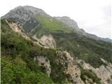 2 2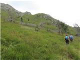 3 3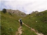 4 4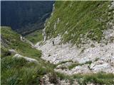 5 5 6 6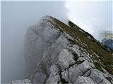 7 7 8 8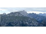 9 9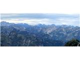 10 10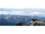 11 11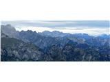 12 12
| (+3) |  | |
|
|