Front line in World War I
|
| Franc604. 09. 2019 21:41:36 |
When we hike in the Western Julian Alps and Carnic Alps (some also in the Dolomites) we often come across remnants of the front (mulatjeres, caverns, trenches, carved paths...). Often it's not clear to me how this line ran - where the Austrians were and where the Italians.
Is there any map or book where it's drawn in. There's quite a bit about the Soča front, but I'm interested in the other part too. Google didn't offer anything smart, or I didn't search right.
|
|
|
|
| miri4. 09. 2019 22:00:53 |
For our battlefields you'll find the answer in the Kobarid Museum. From battlefield models to literature.
|
|
|
|
| mirank4. 09. 2019 22:44:21 |
A while ago I asked myself the same question and found some answers. Basically, the Kingdom of Italy as the aggressor mostly attacked eastward on the section from Pontebba to the sea. The front line in the Carnics didn't move and ran along the current and then state border up to Kreuzbergpass-Passo di Monte Croce di Comelico. From there further along the border of South Tyrol-province Trentino Alto Adige, along which the state border between the monarchies mainly ran at that time. Somewhere I read that the Austrians withdrew from Cortina on the first day of the war? (it now belongs to the Veneto province). Given the positions at Cinque Torri and Mt Cristallo, it's very likely because the town was mostly Italian. Exactly where the front line ran south of Marmolada to the Adamello massif I don't know, but it's much further south, a pocket almost to Vicenza, Rovereto, where the famous 52 tunnels line is (still waiting for our visit). Nearby is also Asiago, where fierce battles took place, I think in the 6th offensive, when the AO "punitive expedition" almost succeeded. The front line from the Swiss border runs highest in the Ortler group, via Cevedale, there are 150mm guns above 3200m and when you walk on those vast glaciers nothing is clear. Similarly, maybe a bit higher is the famous hippopotamus (hippo) 150mm gun, on the ridge south of Lobbia Alta hut in the Adamello group. Opposite them the Austrians stood at Corno di Cavento cca 3400m in a cavern with a 100mm gun-insane!!
| (+1) |  | |
|
|
|
|
| bbugari14. 09. 2019 22:56:55 |
In the Julians:
Austrians: Dolje near Tolmin – Vodel – Mrzli vrh – Pretovč – pl. Sleme – Stador – Maselnik – Prag - eastern third of Batognica plateau – Veliki Lemež – pl. Zagreben – Lipnik – Čez utro – Javoršček – Stržišče – Ravelnik – Krlišče – Rombon – Bohinca – Koštrunove špice – pl. Zajzera – Strehica (peak and pasture) – pl. in Duplje – pl. Brda – Lužnica - Tablja
Italians: Gabrje – pl. Lapoč – pl. Leskovca - western two thirds of Batognica plateau – Krnska škrbina – Krn – Krnčica – Vrata – Vršič – Predolina – Slatenik – Bovška kotlina – Bovec – Čukla (except short period at start of 1916) – Črnelska špica – Bavha – Krnji dol – Špik ridge – Krniška glavica – Rudni vrh – Poldašnja špica – Dve špici – over Vančelo – Vrh brda – Velika planina (and saddle) – Lipnik – M. Poccet - Pontebba
|
|
|
|
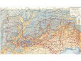
| palček plezalček4. 09. 2019 23:14:57 |
On the net in various languages there's quite a bit to find. I'm attaching one map, the larger version I put on WeTransfer and it can be downloaded for seven days here: https://we.tl/t-SjjOeqTllO
 1 1
| (+2) | | |
|
|
|
|
| bbugari14. 09. 2019 23:52:35 |
In the Dolomites:
Austrians: Cima Dieci (Croda rossa di Sesto) – Forcella Undici – Val Sassovecchio – Torre di Toblin – Monte Rudo – smaller part of Monte Piana (west) – Rauchkofel – Costabella – Sorabances – Croda Re d'Ancona – Val Travenanzes – Lagazuoi (Cengia Martini, western part) – Passo Valparola – Col di Lana (first part of war) – Passo Padon - Porta Vescovo – Passo Fedaia – glacier (western part) – Punta Penia (Marmolada)
Italians: Passo Montecroce Comelico – Cima Nove – Passo della Sentinella – Cima Undici – Val Fiscalina alta – Passo Fiscalino – Monte Paterno – Salsiccia – Tre Cime – Arghena – larger part of Monte Piana (east and south) – Val Popena bassa – Cristallino di Misurina – M. Cristallo – Rufiedo – Ra Štua – Tofane – Castelletto - Lagazuoi (Cengia Marini, eastern part) – Passo Falzarego – Col di Lana (second part of war) – glacier (eastern part) - Punta Rocca (Marmolada)
then roughly: Passo Rolle – Catena di Lagorai – Ortigara - Altopiano di Asiago – Pasubio - summit part of Lago di Garda – Adamello – Passo Tonale – Ortler - Passo Stelvio
|
|
|
|
| bbugari15. 09. 2019 00:00:50 |
For the Soča front I recommend from Vasja Klavora: Koraki skozi meglo and Plavi križ. For Dolomites: Teatri di guerra sulle Dolomiti!
| (+1) | | |
|
|
|
|
| miri5. 09. 2019 06:27:40 |
A couple of pictures for @ mirank. For easier decision.
52 tunnels and Monte Pasubio.
| (+1) | | |
|
|
|
|
| ales505. 09. 2019 21:17:24 |
The Julians are great for exploring the Soča front, Rombon with the mosque on the battlefield under Rombon is especially interesting, 
|
|
|
|
| lingo6. 09. 2019 08:00:16 |
The Julians are really more interesting for exploring the Soča front than, say, the Kamniks, not to mention Pohorje 
The mosque is a chapter unto itself, but it wasn't on any battlefield under Rombon, just like Javorca or the Russian chapel under Vršič. All sacred objects were built deep in the rear of the front. The mosque stood in Log pod Mangartom, and it is interesting only on two photos, since it has been gone for a hundred years unlike the other objects.
On the tourist map Bovec and surroundings, 1:25,000 which is no longer on sale, both Austrian and Italian front lines are marked in our mountains; it is no longer in stores, but on the flea market, as I see, it is sold for 3 euros
| (+4) | | |
|
|
|
|
| turbo6. 09. 2019 11:25:56 |
| (+3) | | |
|
|
|
|
| lingo6. 09. 2019 12:32:24 |
Turbo, you'll probably agree anyway that up there it's the remains of a small prayer room and not a mosque, otherwise we'd have to say there were dozens of churches in the high mountains (but we prefer to call them chapels).
The journalists just used the term mosque for more promotion, because the topic is very relevant for some people.
| (+5) | | |
|
|
|
|
| turbo6. 09. 2019 12:46:52 |
| (+2) | | |
|
|
|
|
| ana6. 09. 2019 13:01:39 |
the link reveals whose interest it is 
| (+3) | | |
|
|
|
|
| djimuzl6. 09. 2019 13:15:35 |
Such a reaction reveals how terrible that is, right?
| (+2) | | |
|
|
|
|
| korl6. 09. 2019 13:20:32 |
best to make a petition to rebuild those two mosques in Posočje,
so you won't just boast in Ljubljana that you have a mosque
| (+1) | | |
|
|
|
|
| darinka46. 09. 2019 13:25:40 |
The mosque was in Log pod Mangartom. It's true that there was a Bosnian unit on Rombon for a while. The Italians were afraid of them, as you know why, because they literally slaughtered with pickaxe handles similar to clubs when they broke into Italian trenches. They probably made a makeshift prayer room there afterwards.
| (+1) | | |
|
|
|
|
| djimuzl6. 09. 2019 14:02:47 |
You have to sign the petition with your full name, otherwise it doesn't count.
| (+2) | | |
|
|
|
You must log in to post a comment:
If you do not yet have a username, you must first
register.