Javor - Monte Lavara (1906 m)
|
| klm2. 09. 2012 09:08:15 |
From Zgornji Pobič (Povici di Sopra) into the wild Resartico stream valley, caught between north faces of Lopič, Vogršček and Javor. From Slips saddle first to Lopič (fine steep grass with many holes and hidden rocks, morning dew perfect for deep slip if careless). Though it's so-called mid-mountains, Italians call Prealps, these mountains are something else - from start to summit +1600m. Then past mentioned saddle to Vogršček and down to namesake pasture - touristy hut - and on to Javor. Fine peak with loop tour, over steep west slope (partly with protections) to ridge then to summit and over east in descent (also partly secured and equally steep). Great view from top to north face and approach valley (Resartico). This could easily be (due to majesty of north face and wilderness of course) somewhere in central Julian Alps. Follows descent to Ungarine pasture (Vogršček) and on towards Poljica pass, but before it right on CAI 726/a to Kadin. No trace of Pozza lakes in cirque, summit grassy ridge quite exposed. Grassy slopes so steep that Kamniški vrh seems flat in comparison?! Descent on CAI 740/a (part secured with cable and on past idyllic Rio Nero shelter (nice view to Musi faces) into same-named valley - gorge. This quite picturesque. Through it back to start. Number of people met: 0. Landscape insanely beautiful, pristine atmosphere. Once you visit Musi, you never forget them and want to return as soon as possible.
| (+3) |  | |
|
|
|
|
| tulipan25. 01. 2013 18:20:29 |
 1 1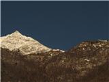 2 2
| (+3) | | |
|
|
|
|
| IgorZlodej6. 10. 2014 19:17:42 |
I started just behind the village Liščace (Lischiazze) in Resia. The path is marked no. 703 and in the first part to the saddle La Forchia extremely nice and soft from fallen leaves. Follows descent to the Black Stream valley, before that branches left path to Cadin, which will need to be done sometime, from south side I've already been to the top. When almost in the valley, somewhat above Rionero shelter branches left path no. 726, which is also nice and leads me to saddle Campidello o Lavera. Views to pastures Confin and Ungarina already known, as I was there five years ago and also on Javor summit from Pušja vas (Venzone-Venčon). Descend a bit to western side, then right away right and pathless (first some gully, then some brushwood) to unnamed point 1504, some kind of SE forepeak of Javor. Further on soon hit a modestly marked trail that brings me to eastern side of the mountain. Follows steep ascent along a kind of gully that in summit part leads to short eastern ridge. From here pleasant ascent to top, just below summit on left traverse some short cables, one torn, could go without them. No view this time, but known from before.
Descended southern path to screes under wall, then pathless to path to pasture. Again up to saddle Campidello, then down Black Stream valley, up again to saddle Forchia and finally down to village Liščace.
| (+3) | | |
|
|
|
|
| Edina30. 06. 2015 12:51:40 |
First time in these parts at all. Surprised by almost vertical slopes wherever you look, also by pastures and the views themselves unknown except towards east.
Lonely and mysterious, pristine, wildly beautiful, hidden and inviting ...
http://stezeinsledi.blogspot.com/2015/06/tam-kjer.html
Happy trails
| (+1) | | |
|
|
|
|
| ločanka6. 12. 2018 22:47:23 |
On Tuesday a sunny day was forecasted, which had to be well used as we knew December days are short. Javor/Monte Lavara was chosen, which fully met our mountaineering expectations, as it was recently admired from the path to M.Cuzzer. Even more, it spiced the tour a bit, as the snow under the summit on the north side was hard and icy, so microspikes would have come in very handy, but unfortunately most left them in the car or at home.
After a quite long drive (155 km and over 2 hours) from the place Venčon we arrived at the tunnel at about 475 m and here our path started in the opposite direction. We did a circular tour via pastures Ungarina and Confin to the summit, we returned via the concrete road through the tunnel to the starting point. Behind us less than 1500 m alt., about 9 hours of walking, so we finished in total darkness. But since an exciting tour was behind us, the mood was accordingly
But not so late that beer at Aljaž would be too late, as we had to do the analysis and toast to the well-chosen tour
 1 1 2 2 3 3 4 4 5 5 6 6 7 7 8 8 9 9 10 10 11 11 12 12 13 13 14 14 15 15 16 16 17 17 18 18 19 19 20 20 21 21 22 22 23 23 24 24 25 25 26 26 27 27 28 28
| (+9) | | |
|
|
|
|
| GITA7. 12. 2018 08:09:01 |
Great! @ločanka, Resia gets under your skin, doesn't it? 
|
|
|
|
| ločanka7. 12. 2018 17:29:03 |
yes, GITA, I'm circling around it and more and more trips nearby reveal themselves Each tour excites me more, this one was really exceptional. Worth doing this path again in spring days when nature wakes up and dresses in other colors. Already looking forward
|
|
|
|
| bagi12. 06. 2019 12:45:58 |
After visiting hills above Resia, this time we headed to the opposite side of this nice valley ... to Muzce. We decided for a visit to Javor and at the same time to scout for future targets. We arrived from Venčon, parked a bit before the tunnel and headed by road to pasture Confin. They were just preparing it for opening. To Javor we went via the western approach, crossed it and descended the opposite side. We continued to pasture Ungarina, from there down to church Sv. Anton and further to parking. Nice tour, about 20 km long and 1500 elevation gain.
Snow on these slopes has completely melted in a good week of heat, but I can't say that for accesses from Resia. Path to Javor via western approach poorly trodden and even worse marked. On eastern side somewhat better. General impression is that both approaches have seen much better times. Protections not perfect, but helpful. Idea was also to continue the path along the ridge over Monte Jouf Ungaria to Lopič, but due to stuffiness no more desire to explore. Ridge looks passable, but definitely very steep.
Coordinates of our starting point: 46.333345, 13.180075
 1 1 2 2 3 3 4 4 5 5 6 6 7 7 8 8 9 9 10 10 11 11 For comparison the shoe is next to it. Here we turned RIGHT to the western ridge") 12 12 13 13 14 14 15 15 16 16 17 17 18 18 19 19 20 20 21 21 22 22 23 23 24 24 25 25 26 26 27 27 28 28 29 29 30 30 31 31 32 32 33 33 34 34 35 35
| (+2) | | |
|
|
|
You must log in to post a comment:
If you do not yet have a username, you must first
register.