|
| kofetarca16. 03. 2012 22:01:37 |
Nice tour you did, we went in summer the opposite way, from Bovec over Učejo to the saddle, down to Trnovo and back to Bovec. Also long and strenuous 
| (+3) |  | |
|
|
|
|
| rinča18. 03. 2012 19:51:43 |
Good job Viharnik, that you came up the southern side. I went the opposite and it seemed to me that the descent on that zigzag road was endlessly long and in between I stopped twice because my hands hurt from braking and shaking I told myself that up there never I told myself that up there never
| (+1) | | |
|
|
|
|
| viharnik18. 03. 2012 21:25:21 |
Yes, uphill from the south is really quite strenuous not so much because of the elevation difference (Kobarid 258m-Na Verlih 1400m), but because of the gravel and larger stones that stop you at every pedal turn, sometimes a stone, sometimes gravel, sometimes jumping. All that is outweighed by the special light coastal-mountain air with ambiance and luxurious views. Worth every repetition of the tour and visit to pleasant Kobarid or Bovec. Nearby is also the Napoleonic path in the gorge of the emerald Soča. For the ridge path I saw that sign in Kobarid for Stol in 4 hours.
| (+1) | | |
|
|
|
|
| dm7213. 10. 2013 20:31:45 |
Not to the top of Kobariški Stol, but only to planina Božca. Just a bit different than described above. Tour start at Boka along the main road to the former border crossing Učja, where a few meters before a gravel road turns left. A bit of asphalt at the beginning. To the pasture a still quite well-maintained path winds. From Žaga to planina Božca it's over 13km. The location of this 1370m high pasture is very scenic. From here I continue to the other Kobariška side, where soon a path branches left towards Trnovo along which my today's descent went. (On the right, the road descends the slope of Stol into Breginjski kot). The descent is extremely picturesque as we see the valley low below all the time. The ridge crossing is about 3km, then the path (marked for Trnovo) descends into the forest, where at the beginning the path is not drivable, except for brave downhillers with full-suspension bikes. We carry the bike for about 10min, then we reach the path again, which is worse at first, then better and better. To Trnovo 8km descent. Then along the main road back to Boka. Wonderful tour, those who know it will agree it's one of the most scenic MTB tours with beautiful views either from the village Sedlo or the one I did. Worth a visit.
 1 1 2 2 3 3 4 4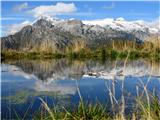 5 5 6 6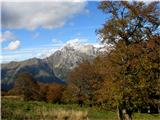 7 7 8 8 9 9 10 10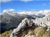 11 11 12 12 13 13 14 14 15 15 16 16 17 17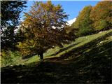 18 18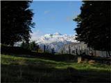 19 19 20 20
| (+8) | | |
|
|
|
|
| Becar29. 05. 2016 13:55:27 |
Is there still any snow on the steeper sections on the direct path from Breginj?
|
|
|
|
| stella29. 05. 2016 17:08:51 |
No, the path is dry. I returned to Breginj via the direct path last Saturday.
Good luck.
| (+1) | | |
|
|
|
|
| Crazy climber27. 06. 2017 10:05:33 |
Yesterday we went with family from Breginj to Stol, nice view, later Rombon opened up too, central Julian Alps were covered. Then we traversed to Mali Muzec to bivouac and back to Breginj, crazy nice day. Good luck! 
| (+2) | | |
|
|
|
|
| maregol22. 07. 2017 18:34:28 |
Hi.
Interested in the condition of the road from Učeja or Žaga to planina Božca? Thanks
|
|
|
|
| alyas1. 09. 2017 15:56:03 |
Žaga - Učeja - Kobariški Stol (Božca) - Trnovo - Žaga (circular MTB tour, conditions 27.8.2017)
As for previous opinions, we probably all agree it's truly one of the most beautiful and scenic MTB tours here, but unfortunately has that one small flaw that you can't ride it fully, but have to push the bike for a good km of trail from planina under Starinjski vrh through forest on hiking path, sadly dismount briefly. But right after follows generous adrenaline descent part on more or less flat forest road all to Trnovo, where without good suspension or amortizer it can shake you well, but we're used to that anyway. Some go up also in this direction, we met a few, but I think the originally described tour direction is still better.
Other conditions: road from Učeja to Božca is solid, locally macadam a bit more stony and rough, some places more gravel, but with wide tires and good tread no problem. Anyway where a 2WD van can drive up (that transport paragliders up), MTB surely can too. Trip possible even on hot day, as north side of Kobariški Stol is almost fully forested providing pleasant shade on ascent. Although this summer extremely hot with little rain, still could supply with water at all usual spots along path and at bivak Hlek.
 1 1 2 2 3 3 4 4 5 5 6 6 7 7 8 8 9 9 10 10 11 11 12 12 13 13 14 14 15 15 16 16 17 17 18 18 19 19 20 20 21 21 22 22 23 23 24 24 25 25 26 26 27 27 28 28 29 29 30 30
| (+2) | | |
|
|
|
|
| oselica17. 10. 2018 17:01:45 |
I'm curious how much walking time from picture 7 by alyas (above) to summit of Stol
|
|
|
|
| oselica17. 10. 2018 19:58:21 |
Janez, thanks for the info
| (+1) | | |
|
|
|
You must log in to post a comment:
If you do not yet have a username, you must first
register.