|
| garmont19. 04. 2011 19:52:53 |
Today I climbed to the 772 m high Kotečnik, which climbers know, as it's one of the largest natural climbing areas in this part of Europe.
Along the "alpinistically marked" path I climbed under the walls and then via pathless terrain over a fairly demanding jump I climbed towards the summit. The path led above the climbing walls and is partially exposed, but in dry conditions it doesn't pose major difficulties. It is interesting that there are two logbooks on Kotečnik, one for the eastern and one for the western (lower) summit.
Then I continued along the marked path to Šmohor and then descended to the parked car. It took about 4 hours.
Best
| (+2) |  | |
|
|
|
|
| garmont20. 05. 2011 16:54:04 |
Yesterday I marked the path to Kotečnik, which our PD maintains.
Our marked path continues from the lower summit of Kotečnik to the higher summit. There's still no summit log on the lower one.
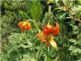
On the path I noticed a large number of Carniolan lilies. Very nice view, so the marking work passed quickly.
Regards
 1 1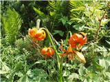 2 2
| (+2) | | |
|
|
|
|
| geppo21. 07. 2014 18:41:44 |
Just as you wrote..
sunglasses, plastic bottle, tin can, climbing in safe environment...
but if they had 200m under ass somewhere in Alps, crumbly walls, they'd have little time to leave trash behind..and not all are like that, but quite a few who just move from crag to crag, real higher walls they don't want...
lp
| (+2) | | |
|
|
|
|
| andi223. 04. 2017 19:10:52 |
Today on Kotečnik (Brezniške peči in miniature, two summits! ) and descent first micro path to Osojnik under walls and circular back to Zabukovica. Nice views above walls, a good hour and a half short Recommend if you're ever nearby. ) and descent first micro path to Osojnik under walls and circular back to Zabukovica. Nice views above walls, a good hour and a half short Recommend if you're ever nearby.
| (+3) | | |
|
|
|
|
| andi25. 05. 2019 21:27:21 |
A bit before seven from Liboj to Kotečnik. From parking behind climbing area along tracks to saddle. Before track drops past carved crosses on trunks and white marks to ridge (no. 21). Then along the ridge, which is locally demanding, to top. Due to approaching darkness I hurried too much (40min), don't quite reach cirque as cold and dark push me further. Descend ridge to farm then walk road (ca 4km) to valley. At car in dark and rain. In wet need to be careful, otherwise nice hill.
| (+1) | | |
|
|
|
|
| garmont10. 04. 2020 15:36:55 |
Today straight from home to summit.
Edge of quarry then ridge nice unmarked path leads to eastern higher summit. From there ridge to western then over saddle towards Zabukovica home.
Good three hours real summer heat.
Lp
| (+6) | | |
|
|
|
|
| garmont31. 10. 2020 13:59:30 |
In my municipality...
| (+2) | | |
|
|
|
|
| zokipoki26. 05. 2021 08:01:51 |
Congratulations!
|
|
|
|
| bagi20. 11. 2023 13:06:42 |
We repeated the route from 2021, but this time in reverse order. We both agreed it's an excellent variant mainly because of the long warm-up on the flat and overcoming the steepest parts of the path uphill.
We started at the parking lot by the train station in Celje. Parking is free on Saturdays and Sundays there, and you couldn't wish for a better starting point . We continued through the park along the Savinja riverbank all the way to the Levske bridge. That's 4 km and despite the fog and cold we warmed up well before continuing. We crossed the river and after numerous junctions climbed towards Dom na Brnci. We followed the marks all the way and just before the hut caught the first sun.
Then descent towards the quarry in Liboje, soon after a steep ascent to Kotečnik. This junction isn't officially marked, but there's a modest path marked with red lines. It goes all the way to the ridge top, where regular marks appear. From here we were under the watchful eyes of hunters who were just having a drive on wild boars. Luckily their eyes didn't water too much and after longer ridge walking we successfully crossed Mali Kotečnik too  . Soon after we descended to the saddle and on the other side steeply ascended again to the road under Gozdnik. Then walking on gravel to Dom na Šmohorju and well-deserved rest. . Soon after we descended to the saddle and on the other side steeply ascended again to the road under Gozdnik. Then walking on gravel to Dom na Šmohorju and well-deserved rest.
After a good lunch we continued straight past the abandoned building and headed towards Tremarije. Soon after Debro settlement we caught the marks for Veliki Slomnik, where surprisingly the first drops of unannounced rain caught us. Luckily it wasn't bad, so we quickly descended, crossed the road and headed towards Hom. From there we took the line towards Celje and about an hour later we were at Miklavž's church right above the town. Then descent to Savinja and back to start. Summary ... the whole path is passable without issues despite weather whims, no part washed away, a few fallen trees don't hinder progress.
Coordinates of start at train station: 46.2264889N, 15.2671975E
 1 1 2 2 3 3 4 4 5 5 6 6") 7 7 8 8 9 9 10 10 11 11 12 12 13 13 14 14 15 15 16 16 17 17 18 18 19 19 20 20 21 21 22 22 23 23 24 24 25 25") 26 26 27 27 28 28 29 29 30 30 31 31 32 32 33 33 34 34 35 35 36 36 37 37 38 38 39 39 40 40") 41 41 42 42
| (+9) | | |
|
|
|
|
| zokipoki20. 11. 2023 16:26:45 |
Wow, a proper loop! Congratulations!
| (+2) | | |
|
|
|
|
| bagi21. 11. 2023 08:01:16 |
Thanks Zoran, we almost ran out of daylight .
|
|
|
You must log in to post a comment:
If you do not yet have a username, you must first
register.