| rozka2. 09. 2019 20:07:40 |
The wild animals haven't let me out of Resia's embrace for a while , so finally I decide on the long-planned peek into the Resartico valley. , so finally I decide on the long-planned peek into the Resartico valley.
Well, when you think nothing can surprise you anymore, go to Resartico . In the morning I park before the road barrier, above "Pobič", past the only sleeping bivouacker . In the morning I park before the road barrier, above "Pobič", past the only sleeping bivouacker , and bite into the road, which I wouldn't mind driving all the way to the end , and bite into the road, which I wouldn't mind driving all the way to the end . My eyes were drawn up to the walls above me and I was really curious where the path to the shelter and the now abandoned mine is routed, which I reach quite quickly. The Resartico shelter is really built on the ideal and only flat spot, remnants of former life are visible for another part of the path as I ascend path 702. . My eyes were drawn up to the walls above me and I was really curious where the path to the shelter and the now abandoned mine is routed, which I reach quite quickly. The Resartico shelter is really built on the ideal and only flat spot, remnants of former life are visible for another part of the path as I ascend path 702.
When the path turns from the forest across a mini landslide gully, I see the mark left, but still it pulls me right because the path is clearly trodden, but only to the corner , since nothing is visible up left, so I think probably the landslide took the path and it goes around. I go back and yes, over the rocky step and into steep, slippery grass, where the chain still stands and is really helpful. Well, higher up it was still all wet in the morning, slippery, full of leaves and slippery roots, so I was really careful stepping. Once you handle this part, the path seems nicer, the steepness eases, you cross the pathlet that the landslide half carried away and bypass possible on the left side, across the gully and yup, you're before a new obstacle. Marks disappear, I got lost in the bushes, tall grass and it stopped me only the "wall" of eco-bio nettles. I look around a bit and spot something that could be like a pathlet. I descend a bit and find the right path, but that didn't mean end of the fight with vegetation. The path is really unpleasant in one part, holes, grass, but after that the world opens up, two more zigzags and I stood, finally, on Slips saddle. From here wide views open to again, for me, something new. , since nothing is visible up left, so I think probably the landslide took the path and it goes around. I go back and yes, over the rocky step and into steep, slippery grass, where the chain still stands and is really helpful. Well, higher up it was still all wet in the morning, slippery, full of leaves and slippery roots, so I was really careful stepping. Once you handle this part, the path seems nicer, the steepness eases, you cross the pathlet that the landslide half carried away and bypass possible on the left side, across the gully and yup, you're before a new obstacle. Marks disappear, I got lost in the bushes, tall grass and it stopped me only the "wall" of eco-bio nettles. I look around a bit and spot something that could be like a pathlet. I descend a bit and find the right path, but that didn't mean end of the fight with vegetation. The path is really unpleasant in one part, holes, grass, but after that the world opens up, two more zigzags and I stood, finally, on Slips saddle. From here wide views open to again, for me, something new.
On the saddle I pause a bit, since I had no goal, but a little bird whispered that one summit is higher than the other and the higher is closer, hehe, I quickly resolved the dilemma , I traverse right, a bit up, then traverse again and then shock... in front of me whole three "crazies" , I traverse right, a bit up, then traverse again and then shock... in front of me whole three "crazies" , who turn out to be IT soldiers on some exercise. I don't know who was more surprised, they probably thought I surely got lost. Together we step on the summit of Lopič – Monte Plauris. Wonderful views, even though I was early, clouds were gathering and given the abundant rain in Muzci, I didn't linger much. Photo, couple words, couple nuts and I was descending. To the bushes ok, then got lost again, went too much right, then back up and found marks and pathlet intertwined with animal tracks, but the labyrinth was conquered , who turn out to be IT soldiers on some exercise. I don't know who was more surprised, they probably thought I surely got lost. Together we step on the summit of Lopič – Monte Plauris. Wonderful views, even though I was early, clouds were gathering and given the abundant rain in Muzci, I didn't linger much. Photo, couple words, couple nuts and I was descending. To the bushes ok, then got lost again, went too much right, then back up and found marks and pathlet intertwined with animal tracks, but the labyrinth was conquered . Carefully over the slippery steep and here the chain proves very helpful, although stepping out of it wasn't the most elegant, especially in damp . Carefully over the slippery steep and here the chain proves very helpful, although stepping out of it wasn't the most elegant, especially in damp . .
On the way I stop at the mine too, no entry, caves and closed spaces don't excite me, so I descend a bit more and enjoy a long break at the hut. Meanwhile some drops started, but nothing bothers me here anymore, maybe only the previous poster's mention that you can meet some viper here
The path is demanding, especially wet, you need a bit of nose in the greenery, otherwise there are marks and transparent ribbons that completely get lost in the green garden, there are a couple secured sections, but mostly the path is unsecured.
Descent back to the car passed in enthusiasm over the tour and how you struggle to reach one of the Muzci summits, which don't even reach over 2000m.
27.08.019
 1 1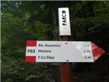 2 2 3 3 4 4 5 5 6 6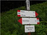 7 7 8 8 9 9 10 10 11 11 12 12))") 13 13 14 14 15 15 16 16 17 17 18 18 19 19 20 20 21 21
| (+7) |  | |
|
|