|
| turbo16. 10. 2023 10:39:59 |
Ciao Alessio,
if you went the other way, you'd help a bit  The shelter is clean and tidy, it'd be nice to sleep up there once and catch sunrise on Belvedere. Say in winter, in snow, then it could be fairytale-like, also sunset the evening before The shelter is clean and tidy, it'd be nice to sleep up there once and catch sunrise on Belvedere. Say in winter, in snow, then it could be fairytale-like, also sunset the evening before 
| (+1) |  | |
|
|
|
|
| bagi15. 05. 2026 10:02:00 |
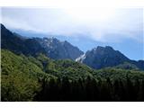
For the final day of our excursion with the neighbors, we were rewarded with one of the most beautiful trails in the heart of the Carnic Alps, suitable for every hill walker. Comfortable, scenic, nowhere difficult, mostly military. We've already walked many things around there, but this trail combination hid from us for a long time .
We started in Dordolle, an old village that's interesting in itself. There we turned onto trail 422 and walked clockwise. We returned from the other side via 425, which also ends in Dordolle. This direction of walking is especially recommended because we hiked in the shade both on the ascent and return.
But nicely in order. Trail 422 initially descends a little, then overcomes the steep slope in numerous zigzags. Nothing strenuous, beautifully laid out. This way we reached the only summit that day, the adjacent Monte Forchiadice. A neat sign points to it and it's definitely worth climbing. The summit is a viewpoint and for anyone without plans to ascend Monte Vualt, it's an excellent choice.
We returned to 422, which is also Alta Via CAI Moggio and has additional yellow-red markers. Soon we were at bivouac Cjasùt dal Sciôr, which stands at a scenic spot. Once it was a military post and the army knew where to place the structures. After a short break, the descent followed on 422 all the way to the junction with 425. We skipped Monte Vualt this time because we had already hiked the demanding ridge trail Sentiero Palis d'Arint years ago. Via 425 we then reached the military hospital Vualt and even lower to the hut Rifugio Vualt. The first is wide open, the second still closed.
Then came a turnaround towards the starting point, and that still on trail 425. It brought us to the Forcella Vualt saddle to the junction with the aforementioned ridge trail, after which a proper descent into the valley followed. At the hamlet Soval the trail levels out again and we arrived in Dordolle from the other direction. The loop was closed. In short … worth repeating . More in the photo story ...
Coordinates of the starting point (Dordolle): 46.4658272N, 13.1921364E
 1 1 2 2 3 3") 4 4 5 5 6 6 7 7 8 8 9 9 10 10") 11 11 12 12 13 13 14 14") 15 15 16 16 17 17 18 18 19 19 20 20 21 21 22 22") 23 23 24 24 25 25 26 26 27 27 28 28 29 29 30 30 31 31 32 32 33 33 34 34 35 35 36 36 37 37 38 38 39 39 40 40 41 41 42 42 43 43 44 44
| (+10) | | |
|
|
|
|
| bbugari115. 05. 2026 15:46:09 |
Bagi, from the bivouac below the Vualt summit, was it visible if there's still any snow under the Fonderis saddle, under Čuk (Zuc)?
|
|
|
|
| bagi15. 05. 2026 16:47:40 |
There is definitely still snow. We met two Czechs who turned back while trying to cross the massif. I'm attaching a photo from in front of the Vualt hut.
 1 1
|
|
|
|
| grizo15. 05. 2026 17:16:12 |
May Day view from the bivouac.
 1 1
| (+1) | | |
|
|
|
|
| grizo15. 05. 2026 17:19:12 |
Bagi, in Dordolli they have a special trolley, a small forklift that can drive through narrow alleys.
| (+1) | | |
|
|
|
You must log in to post a comment:
If you do not yet have a username, you must first
register.