|
| ksena11. 01. 2013 17:06:13 |
On Saturday, 5.1. we crossed under Migovec to pl. Razor and at the junction to Tolmin Kuk no tracks or steps were visible. Would need to break trail quite a bit, as snow is wind-packed in places and doesn't hold human weight. Probably sections with hard snow in between, like on our path. That's the situation from Tolm. Meadows. Maybe from pl. Razor under Škrbinska plošča and further to Kuk it's trodden.??
| (+1) |  | |
|
|
|
|
| mirank11. 01. 2013 21:36:31 |
On Sunday footprints were visible in that direction. Don't know more, as we turned right to Vogel. We were early, so ascent in shade went without heavy trailbreaking.
|
|
|
|
| SPIDER11. 01. 2013 22:10:48 |
I was on Tol. Kuk on Wed 9. Little snow and it doesn't sink, nice walking with crampons. But only till tomorrow, Sunday different story. No pics cuz camera left me week ago on Prehodcih, took shortcut few hundred m toward Tolminka source No pics cuz camera left me week ago on Prehodcih, took shortcut few hundred m toward Tolminka source
| (+4) | | |
|
|
|
|
| mošt9. 05. 2015 16:47:07 |
Ridge traverse Škrbina - Bogatin
Day for gods. Still enough fitness, though last year I rested more.
Early morning start from Tolminske Ravne. Chose unmarked locals' path but soon realized I had missed it, so continued by feel to path from Spodnji Kal to Razor. Continued to Razor, at first junction to Škrbina, where part of scree still under snow - easier walking, snow sinks just right for safe steps.
At Škrbina cooled by wind from Bohinj side, which strengthened during the day.
Under Podrta gora still large snowfield, but not icy, so crampons stay in pack. Ridge from Tolmin Kuk to Bogatin snow-free, path and views pure enjoyment.
From Bogatin saddle straight off-trail down to kasarne which I always admire.
From there path easy, except descent to Dobrenjščica and then regaining height. Stop at chapel on Hudi klanec, avoided small snow slide in gully under Tol. Kuk and soon at pl. Kal. Quick descent to car and tour done.
 1 1 2 2 3 3 4 4 5 5 6 6 7 7 8 8 9 9 10 10 11 11 12 12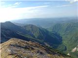 13 13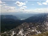 14 14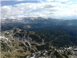 15 15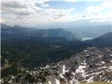 16 16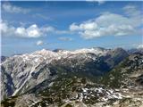 17 17 18 18 19 19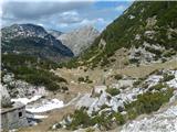 20 20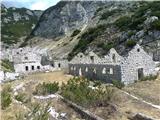 21 21 22 22 23 23 24 24 25 25 26 26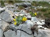 27 27 28 28 29 29 30 30 31 31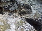 32 32 33 33
| (+10) | | |
|
|
|
|
| Edina6. 06. 2017 14:36:13 |
| (+4) | | |
|
|
|
|
| miri6. 08. 2020 16:57:47 |
Beautiful tour. "Just" right for one shift.
| (+3) | | |
|
|
|
|
| Trobec6. 08. 2020 18:11:57 |
@miri, exactly... definitely nicer such a shift than lately when more office... 
| (+1) | | |
|
|
|
|
| GregorD12. 06. 2021 19:32:38 |
Today hiked from Tolmin Meadows via Migovec to Kuk, continued along the ridge to Mali vrh and then descent to Planina Razor and back to Tolmin Meadows.
On the western side of Migovec there are three snowfields that can be bypassed/climbed on the left or right. The ridge is steep as well as the path to Kuk, Zeleni and Mali vrh. To Razor however you need to cross quite extensive snowfields.
| (+4) | | |
|
|
|
|
| wajskar14. 08. 2021 22:28:27 |
Yesterday's visit to Migovec and Kuk. Started at Tolmin meadows, ascent continued via Planina Kal to Migovec and Kuk. Then descent over Škrbina to the Bohinj side and return via Preval Globoko and Razor planina to the starting point. Beautiful but hot day. Path without special features.
| (+3) | | |
|
|
|
|
| Tomco19. 06. 2026 15:41:21 |
Excellent, Darinka.
Can you tell me about this path above Dobrenjščica (pictures 10-16)... Is this the part that I marked with blue dashes on the map?
I'm planning a tour in these parts this summer, but I'm not familiar with the path. I would go right there, otherwise it gets quite a bit longer via Dobrenjščica...
 1 1
| (+1) | | |
|
|
|
|
| darinka419. 06. 2026 15:48:51 |
Go further from the chapel. The bend before the descent towards the hunting hut Dobrenjščica is now clearly visible. You can see it in the picture, the dwarf pines are cut at the start. Last time they weren't. Further on, the path is traceable. Only in one part we went astray. But we quickly found the right fork. In pictures 8 and 9 is the start of this, I'd say about an hour shorter path. Probably that blue line. Because the path once existed. Then they abandoned it due to the earthquake. Now the hunters maintain it. Where there are demanding passages they put cables. Further up, the ladder helps. We had a chamois somewhere above us that dislodged some stones. But that part isn't long. We were quite surprised that the cut dwarf pines are visible there where this path starts. Several times you have to cross scree. Be careful there.
 1 1 2 2
| (+2) | | |
|
|
|
|
| Tomco19. 06. 2026 16:48:39 |
| (+1) | | |
|
|
|
|
| darinka420. 06. 2026 13:42:03 |
Tomco thanks and good luck on the way. 
|
|
|
You must log in to post a comment:
If you do not yet have a username, you must first
register.