Ravenska Kočna - Kranjska koča na Ledinah (hunter's way)
Starting point: Ravenska Kočna (1000 m)
| Latitude/Longitude: | 46,38500°N 14,53640°E |
| |
Route name: hunter's way
Walking time: 2 h 15 min
Difficulty: partly demanding marked way
Elevation gain: 700 m
Elevation difference along the route: 700 m
Map: Kamniške in Savinjske Alpe 1:50.000
Recommended equipment (summer):
Recommended equipment (winter): ice axe, crampons
Views: 67.856
 | 4 people like this post |
Access to starting point:
From the Gorenjska motorway, Kranj or Preddvor, we drive to Zgornje Jezersko, then approximately 1 km after the Petrol gas station, we turn right in the direction of Planšarsko jezero and Češka koča. Further, we drive past the mentioned lake, and then the road leads us through a larger meadow, where the asphalt ends and from which a beautiful view opens up on the surrounding mountains, and then the road returns into the forest, where it first crosses a torrent. A little further, the road splits, and we continue on the right road (left Gorniški center Davo Karničar and also the footpath to Jenkovo planina and former starting point for the mentioned mountain pasture), on which we quickly reach a large marked parking lot, where we park.
Route description:
Somewhere in the middle of the large parking lot a passage opens to the left, by which there are mountaineering signs for Velika Baba, Goli vrh and a sign for the hunting path on Ledine. We start on a cart track which brings us to the edge of a meadow, where on the left side we will notice Gorniški center. We continue straight to well-visible signposts at the nearby junction, from which we continue right (straight Goli vrh, Velika Baba) in the direction of the mountain hut on Ledine (on the sign Vadine). The path ahead for some time still runs through the forest, then below the mountain walls of Velika (Koroška) Baba the forest starts to thin, and the path more and more passes among dwarf pines. A little further, we cross also a mighty torrent, which we had on the right side all the time during the walk, then we join the path from the bottom station of a cargo cableway, where used to be a starting point. The path follows the torrent for a short time or to the beginning of the steeper part of the path. The path then steeply ascends, and we also get help from some steel cables, with the help of which we ascend a level higher (in wet danger of slipping). Difficulties then decrease, and the path continues steeply ascending, mostly on the northern slopes. After an hour and a half of walking, we come to a pleasant resting place, where a bench and table delight us. Near the resting place, which is also a nice viewpoint, there is a memorial plaque in memory of the victims of the crashed helicopter. From here to the hut, which we reach after a good 20 minutes of further walking, there are no more technically demanding spots.

Photos:
 1
1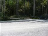 2
2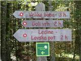 3
3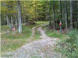 4
4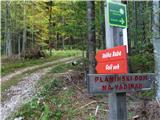 5
5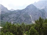 6
6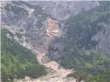 7
7 8
8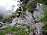 9
9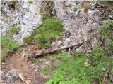 10
10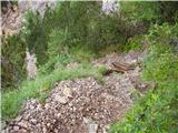 11
11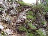 12
12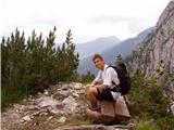 13
13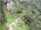 14
14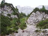 15
15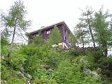 16
16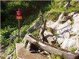 17
17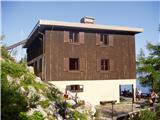 18
18
Discussion about the trip Ravenska Kočna - Kranjska koča na Ledinah (hunter's way)
|
| Ljubljana24. 09. 2009 |
I recommend the path especially to women, you need to stretch quite a bit to reach the hut. In wet conditions the descent is slow, there are several pegs and steel cables. Good luck.
|
|
|
|
| peterhaf28. 04. 2010 |
Would a Labrador dog that has already done some two-thousanders (Savinjsko sedlo, Storžič, Kladivo, Viševnik) manage the trail?
|
|
|
|
| mosovnik28. 04. 2010 |
If your Labrador has "sniffed" the mentioned peaks, you can set off on the mentioned trail with him without worry. Possibly, but only possibly, he might need a little help at one spot. But not necessarily. I also have a Labrador and we've covered quite a few and he's never "disappointed" me, even though we've been on fairly exposed terrain sometimes.
Good luck!
|
|
|
|
| ZOJA18. 02. 2011 |
Hello mountain lovers!
What's the path to Kranjska koča via the hunting path like? Is it still snowy? Do you need crampons maybe? Thanks and best regards
|
|
|
|
| serajko19. 02. 2011 |
lp
I haven't been there myself, but from experience I would take full gear since quite some snow has fallen
|
|
|
|
| ZOJA31. 03. 2011 |
Hello, can someone from first hand tell us what the mentioned path is like. If it's still icy, we would wait a bit longer......otherwise we would go up on Sunday with the dog......best regards
|
|
|
|
| tonek71. 04. 2011 |
given the temperature, you can already nicely reach the signpost, although I think it's still unsuitable for the dog, further up today the snow is sinking.
I was at the Črnuče hut and around there, and I believe it will be similar for Kranjska koča, and there aren't many hikers yet to tread the path a bit more, well, trying isn't a sin, especially if you know how far it's still safe for you Good luck
|
|
|
|
| ZOJA1. 04. 2011 |
thanks for the reply and good luck to you too, best regards
|
|
|
|
| marjanovski4. 04. 2011 |
For the information of others... there's a sign at the bottom saying "easy trail" which is a bit misleading... on an easy trail you don't need hand assistance when walking. The trail has wire ropes and some exposed sections.
The trail is dry from the last wire rope onwards, but further on there's increasingly a lot of very wet snow.
|
|
|
|
| ZOJA18. 05. 2011 |
How is the mentioned path today, can someone tell from first hand?lp
|
|
|
|
| velkavrh30. 06. 2011 |
Yesterday I went along this path to the hut at Ledine. I returned via the Slovenian climbing path. Otherwise it's more recommended to go the other way, only if we don't like wire ropes, of which there aren't too many on the Slovenian one. The hut offers pleasant rest for further tours or to Rinke, to Baba or towards Okrešelj and of course pleasant chat with the caretakers. They will repair Žrelo this weekend since some wire ropes are torn. They know exactly in the Czech hut!
|
|
|
|
| el rocco20. 08. 2011 |
Today I went with my family on this tour along the hunting path towards Kranjska koča. I must say it was a real family outing. The tour is not strenuous, weather ideal. I was a bit skeptical about the pegs and cables, but it turned out there was no panic. It was more necessary to watch the wet rocks from yesterday's rain. Anyway, on the way back we stopped at the restaurant to treat ourselves to some cold drinks. Since everything under the shelter was occupied, I asked the burly guy at the bar if he could open the large umbrellas by the terrace for some shade because the sun was burning abnormally. He replied no because the wind might blow them away and consequently break them. I don't know where he found the wind since it was completely still outside, and when I asked again he didn't serve me even 5%. I kept my thoughts to myself, got in the car and drove to Preddvor to the lake and was of course served properly....otherwise everything super.
|
|
|
|
| cawt28. 06. 2012 |
I'm interested how it is, if we go on this path to Kranjska koča and back via the path past Češka koča, so we don't go up and down the same path... any advice?
|
|
|
|
| Kokta9. 07. 2012 |
Today they were renovating the hunting path.
|
|
|
|
| jocjoc9. 07. 2012 |
Excellent work done. When the work is finished, the path will be great for building running fitness for the mountains.
|
|
|
|
| Enka30. 08. 2015 |
The hunting path is beautiful as always. On descent be a bit more careful, as the rocks are wet. And it could use a little sweeping . .
|
|
|
|
| travi6. 08. 2017 |
I need help; the glacier under Skuta is above Kranjska koča. But nowhere does it say if from Kranjska koča to the glacier and how demanding it is.
Can you help?
thanks
|
|
|
|
| Enka6. 08. 2017 |
You reach the glacier along the path from Kranjska koča towards Ledinski vrh (Jezersko and Savinjsko sedlo, Okrešlje). It is at the top of a steep scree slope where no marked paths lead.
|
|
|
|
| Valgirt slo 17. 10. 2019 |
Is the hut open this weekend 19/20.10.2019?
Is the stamp accessible even if the hut is closed...?
Lp. Stane
|
|
|
|
| Valgirt slo 18. 10. 2019 |
I'm wondering if the stamp is somewhere in the winter room or outside and if it's possible to stamp the booklet without the hut being open...
Thanks
|
|
|
|
| lina1222. 07. 2024 09:41:05 |
Yesterday I intended to go on the hunting trail to the hut on Ledinah, but I had to turn back, because (I assume due to the consequences of Friday's storm) I couldn't find the trail. About 5 min after the junction, when you go right towards "Na prodih", you need to cross a scree, but it was so cluttered with larger rocks that the trail couldn't be found. Has anyone else had such an experience, or did I just not explore well enough? Thanks
|
|
|
|
| Tine car22. 07. 2024 21:22:42 |
Yes, I/we have, their trails are disappearing.
|
|
|
|
| gandalf22. 07. 2024 22:36:07 |
If you go from the cable car station to the hunting trail, you avoid the scree by going right. I don't know what it's like today, but a month ago it was fine.
|
|
|
|
| lina1223. 07. 2024 08:16:11 |
Thank you both very much for the information
|
|
|
To post a comment you must log in:
If you do not yet have a username, you must first
register.