Starting point: Ribniška koča (1507 m)
| Latitude/Longitude: | 46,49740°N 15,25550°E |
| |
Walking time: 3 h 35 min
Difficulty: easy marked way
Elevation gain: 10 m
Elevation difference along the route: 390 m
Map: Pohorje 1:50.000
Recommended equipment (summer):
Recommended equipment (winter): ice axe, crampons
Views: 1.010
 | 1 person like this post |
Access to starting point:
A) From the road Maribor - Dravograd, before the settlement Brezno we turn left in the direction of Podvelka, Ribnica na Pohorju and Ribniška koča. After the bridge over the river Drava we arrive in Podvelka, and we follow the road further in the direction of Ribnica na Pohorju. After approximately 10 km from the bridge over the Drava we arrive at the center of Ribnica na Pohorju, where we go left. There follows approximately 8 km of ascent, mostly on the macadam road, to the mountain hut Ribniška koča, where we park.
B) From Dravograd we drive towards Maribor, after Radlje ob Dravi at the roundabout we leave the main road towards Maribor and continue driving in the direction towards Vuhred, Ribnica na Pohorju and Ribniška koča. After the bridge over the river Drava we arrive in Vuhred, and we follow the road further in the direction of Ribnica na Pohorju. After approximately 10 km from the bridge over the Drava we arrive at the center of Ribnica na Pohorju, where we go right. There follows approximately 8 km of ascent, mostly on the macadam road, to the mountain hut Ribniška koča, where we park.
Route description:
From Ribniška koča we head onto the path in the direction of Jezerski vrh and Ribniško jezero and initially walk on the road by which we arrived at the starting point and which leads us in a gentle descent to the saddle between Mali Črni vrh and Jezerski vrh. At the saddle, where it is also possible to park, we leave the road and head onto the marked footpath, which first gently and then more steeply ascends to the monument on Jezerski vrh, which we reach in approximately 10 minutes of increasingly panoramic ascent.
From Jezerski vrh we continue slightly left in the direction of Lovrenška jezera and Rogla (left Ribniško jezero 5 minutes) and begin to descend through thin forest. Soon a path joins from the left that leads past Ribniško jezero, and we continue first with a still moderate descent through thin forest, then pass into dense forest, and the path descends a little more steeply. During the descent a short path branches off to the left to the memorial for the deceased aviators, and we continue the descent to the saddle Šiklarica. After the saddle we begin to ascend again, at a few smaller junctions we follow the blazes. A little further we pass a spring, after it we ascend quite steeply for a few minutes. Higher the path levels out and brings us from the forest to the meadow Planinka, across which we ascend mostly gently to moderately with ever better views. Higher the path turns right and shortly after a path from Lovrenc na Pohorju joins from the left. There follows some traversing with nice views, then the path enters thin forest, where it runs below the plateau of Lovrenška jezera, consequently crossing a larger number of small streams. After a few minutes of traversing we arrive at a marked junction, where we continue slightly right in the direction of Rogla (left Lovrenška jezera, Koča na Pesku and Rogla via Lovrenška jezera).
Further on we continue for some time without major changes in elevation through the forest, then the forest thins and a nice view opens up reaching all the way to the Karawanks and Kamnik Savinja Alps. A little further the path returns to the forest and on the saddle Komisija joins the path that leads past Lovrenška jezera.
We continue straight towards Rogla and ascend in moderate ascent to the indistinct summit of Ostruščica.
From Ostruščica we continue in the direction of Rogla, and the path leads us further along a poorer road, which in winter is prepared as a cross-country ski trail (when the ski trail is prepared we walk on the parallel walking path), a little lower the path leads us along a pleasant grassy path. After a few minutes we reach an asphalt road, which we follow to the left, but when we arrive below the 4-seater chairlift we continue right, then walk to the upper station of the mentioned cable car, from where we descend in a few steps to the large parking lot near hotel Planja.
From the parking lot we continue along the road towards Koča na Pesku. The road first leads between the football field on the left and the church on the right. As soon as the field ends we leave the road and continue slightly left along the initially parallel mountain path. The path further leads past the NOB monument, after which we gradually enter thin spruce forest. There follow a few junctions, where we follow the signs for the tower on Rogla. A fairly level path that runs along the route of the winter cross-country ski trail brings us after approximately 15 minutes of walking from hotel Planja to the summit of Rogla, where a 30-meter-high observation tower stands.
If there is no danger of thunderstorms, we can climb the mentioned tower at our own risk, from which a nice view opens onto a larger part of Pohorje, and with good visibility also onto the Karawanks, Kamnik Savinja Alps and Triglav.
Ribniška koča - Jezerski vrh 0:15, Jezerski vrh - Ostruščica 2:50, Ostruščica - hotel Planja 15 minutes, hotel Planja - Rogla 15 minutes.

Photos:
 1
1 2
2 3
3 4
4 5
5 6
6 7
7 8
8 9
9 10
10 11
11 12
12 13
13 14
14 15
15 16
16 17
17 18
18 19
19 20
20 21
21 22
22 23
23 24
24 25
25 26
26 27
27 28
28 29
29 30
30 31
31 32
32 33
33 34
34 35
35 36
36 37
37 38
38 39
39 40
40 41
41 42
42 43
43 44
44 45
45 46
46 47
47 48
48 49
49 50
50 51
51 52
52 53
53 54
54 55
55 56
56 57
57 58
58 59
59 60
60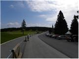 61
61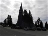 62
62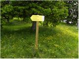 63
63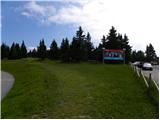 64
64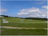 65
65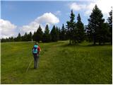 66
66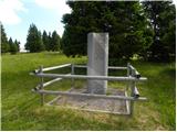 67
67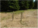 68
68 69
69 70
70 71
71 72
72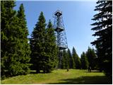 73
73 74
74 75
75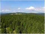 76
76 77
77
Discussion about the trip Ribniška koča - Rogla
To post a comment you must log in:
If you do not yet have a username, you must first
register.