Aljažev dom v Vratih - Bovški Gamsovec (via Sovatna)
Starting point: Aljažev dom v Vratih (987 m)
| Latitude/Longitude: | 46,41280°N 13,84660°E |
| |
Route name: via Sovatna
Walking time: 4 h 45 min
Difficulty: difficult marked way
Elevation gain: 1405 m
Elevation difference along the route: 1410 m
Map: TNP 1 : 50.000
Recommended equipment (summer): helmet, self belay set
Recommended equipment (winter): helmet, self belay set, ice axe, crampons
Views: 65.194
 | 4 people like this post |
Access to starting point:
We drive to Mojstrana, then follow the signs for Vrata Valley. Further on we drive along the toll road, which is closed to public traffic in winter, following it to the large parking lot located a few minutes before Aljažev dom v Vratih.
Route description:
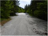
From the large parking lot in Vrata Valley continue along the gravel road, reaching Aljažev dom v Vratih in a few minutes' walk.
From the hut continue straight towards Triglav, Stenar and Kriški podi (right Škrlatica) and proceed along the wide tourist path. The path ahead ascends barely noticeably through the forest belt, where we bypass the winter bivouac on the right side, then the forest thins and after a few more minutes of walking we reach the large peg (monument dedicated to fallen partisan climbers). From the monument continue straight (left Tominškova pot) along the path which gradually returns to the forest and leads us somewhat higher to a marked junction, where we continue right towards Pogačnikov dom (straight Triglav and Luknja). From the junction onwards the path begins to ascend more steeply through the beech forest (the area is called Bukovlje), which leads us just above 1300 m a.s.l. to a pleasant spring that dries up in dry periods. A few more minutes of walking through the forest or higher shrubbery follow and the path leads us out of the forest to the foot of Sovatna, where a quite overgrown path from Bivak pod Luknjo joins.
From here the path becomes increasingly steep and panoramic. The path from which beautiful views of the Triglav north face open up leads us higher to a short slightly exposed passage, where greater caution is needed especially when wet. The path ahead flattens slightly but continues to ascend relatively steeply. An ascent through scree follows, then the valley narrows and the path leads us to a short rocky step over which we ascend with the aid of fixed protections.
Above the step the slope flattens, the path ahead leads us across a series of small basins where we often spot a herd of ibex. Higher the path switches to the left side of the valley, where it then ascends transversely across a wide and on a short section slightly exposed ledge. From there follow a dozen or so steps of walking and the path leads us to the marked junction at Dovška vrata.
Continue left towards Bovški Gamsovec, straight leads to Pogačnikov dom, right to Križ and Stenar. From the junction the path first ascends moderately over rocky terrain then veers slightly right and becomes more demanding. Further on we cross quite steep slopes along cables several times, then veer slightly left and ascend steeply with the aid of pegs and cables. Just below the summit the path from Luknja joins from the left and only a short ascent to the panoramic summit remains.
Starting point - Aljažev dom 0:05, Aljažev dom - spring in Bukovlje 1:25, spring in Bukovlje - Dovška vrata 2:30, Dovška vrata - Bovški Gamsovec 0:45.

Along the route: Aljažev dom v Vratih (1001m), Spomenik padlim partizanom gornikom (1020m), V Plazičih (1040m), Izvir v Bukovlju (1317m), Bukovlje (1418m), Dovška vrata (2176m)
Photos:
 1
1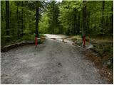 2
2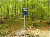 3
3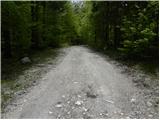 4
4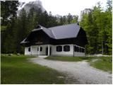 5
5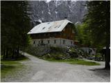 6
6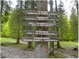 7
7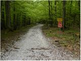 8
8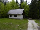 9
9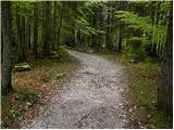 10
10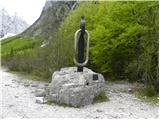 11
11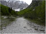 12
12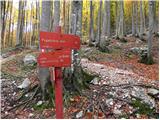 13
13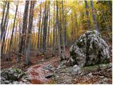 14
14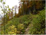 15
15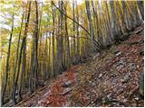 16
16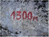 17
17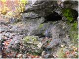 18
18 19
19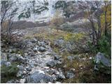 20
20 21
21 22
22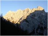 23
23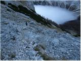 24
24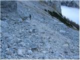 25
25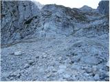 26
26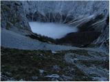 27
27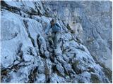 28
28 29
29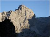 30
30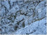 31
31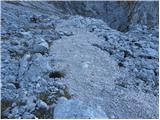 32
32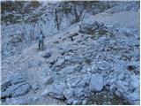 33
33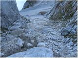 34
34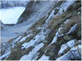 35
35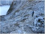 36
36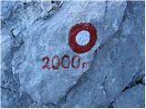 37
37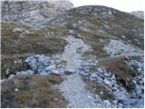 38
38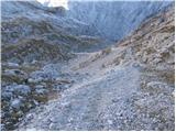 39
39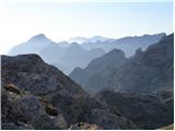 40
40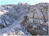 41
41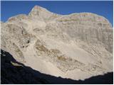 42
42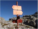 43
43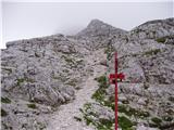 44
44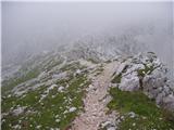 45
45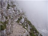 46
46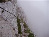 47
47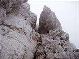 48
48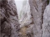 49
49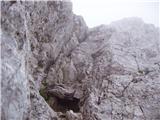 50
50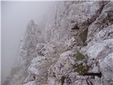 51
51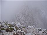 52
52 53
53
Discussion about the trip Aljažev dom v Vratih - Bovški Gamsovec (via Sovatna)
|
| Nacek26. 08. 2009 |
Yesterday we went with colleagues on this path to Bovški Gamsovec and we were more than rewarded for the effort. You can really see a lot - Triglav with the north face (probably no better view of it), Razor, Prisank, Mangart, Jalovec, Trenta,...
The path is quite demanding because it gains height very quickly, markings are somewhat poorly marked only in the last part of the ascent, but it's hard to get lost.
But I would recommend the path only to those who have no problems with precipices, because towards the end there are more and more, but it is true that the path is well secured there.
Bovški Gamsovec is a good goal also because there is actually no crowd, and you see many things - from marmots, ibex, edelweiss, etc.
|
|
|
|
| maremarcus9. 07. 2010 |
As of yesterday the path is dry, well marked, ropes are holding and pitons are good.
|
|
|
|
| Bojan_A9. 07. 2010 |
I visited it today too and can confirm that the path is dry and undamaged. I also agree that the view is exceptional, especially on Triglav through Vrata and on Kriške pode.
|
|
|
|
| trilko9. 08. 2010 |
Over the weekend markers were installing new cables, presume replacing old ones.
Path really well protected, though knees may weaken momentarily looking at sheer walls. Summit view truly divine.
|
|
|
|
| sabina196725. 08. 2011 |
A long hidden wish to meet the wall and pegs was fulfilled for me yesterday on Bovški Gamsovec . The path via Sovatno is really steep from the very beginning, but every step is rewarded with wonderful views. Even that bit of fear about the wall dissipated because I had a wonderful friend by my side who helped me at every step . The path via Sovatno is really steep from the very beginning, but every step is rewarded with wonderful views. Even that bit of fear about the wall dissipated because I had a wonderful friend by my side who helped me at every step . The knees really weaken at the sight of the sheer walls . The knees really weaken at the sight of the sheer walls , but the path is really well protected, so you can enjoy those views without worry. At the summit, satisfied with the success, I enjoyed the magnificent views of our father (Triglav) from one side, as well as Jalovec and Mangart, and Križ and Stenar, which will be next time , but the path is really well protected, so you can enjoy those views without worry. At the summit, satisfied with the success, I enjoyed the magnificent views of our father (Triglav) from one side, as well as Jalovec and Mangart, and Križ and Stenar, which will be next time . For the return, we chose Luknja, as descending the scree is much more pleasant. And we didn't regret it, as we encountered a family of ibex resting in the summer heat along the path, and a bouquet of edelweiss cheered us up. It was a wonderful day, full of beautiful and new experiences. . For the return, we chose Luknja, as descending the scree is much more pleasant. And we didn't regret it, as we encountered a family of ibex resting in the summer heat along the path, and a bouquet of edelweiss cheered us up. It was a wonderful day, full of beautiful and new experiences.
|
|
|
|
| mukl20. 07. 2012 |
We visited it on Tuesday, 17.7.2012 and chose the path from Vrata via Sovatno and thank God this site exists where you can see what people write about various routes and paths.
So, really as the description says, this is one of the most beautiful tours in my mountaineering-hiking career, there's really no such view of the north Triglav wall anywhere else and you have it all the time like on the palm of your hand. We also saw chamois, which we practically approached completely.
If anyone wonders about using SVK and helmet, well, it's an individual matter, but I fully agree with user "trilkom" that at times, despite good path protection, looking at the sheer walls can make your knees weak. To cut short, if I had SVK and helmet with me, I would put them on, but they are not absolutely necessary!
To all who hesitate which path up and down, I really warmly recommend climbing via Sovatno, because via Luknja it's scree and you take two steps forward and three back. This path via Luknja might be suitable for descent, but even that not overly, because you kick that scree and then rocks so much that you can hardly wait for it to end, kid, that's how it is
|
|
|
|
| jprim20. 07. 2012 |
Well, Luknja isn't that bad, you just have to place your step right and it's fine.
Cheers!
|
|
|
|
| matjazt29. 07. 2012 |
My wife and I decided based on forum opinions to go up via Sovatno and down via Luknja. We didn't regret it, but the descent over the scree is also very unpleasant. So it's a matter of "taste" and individual preference. We extended the visit to Gamsovec with a visit to Križ and Kriški podi. So: Sovatna, Križ, Pogačnikov dom, Bovški Gamsovec, Luknja. The tour was really excellent and one of the best we've ever done. Truly unique views, we also saw ibex, some chamois, one viper, but no marmots  . The path from Dovških vrat to Gamsovec is really very exposed in places, the view of the cliffs can be frightening and dizzying for many. But no panic. Start from Vrat at 5:45, we returned at 16:00. . The path from Dovških vrat to Gamsovec is really very exposed in places, the view of the cliffs can be frightening and dizzying for many. But no panic. Start from Vrat at 5:45, we returned at 16:00.
|
|
|
|
| _sandra_13. 08. 2012 |
well, yesterday I took exactly the opposite path, up through Luknja and down through Sovatno, and it was perfectly fine views from the top of Bovški Gamsovec are beautiful, Triglav from this side is even more beautiful, at least for me 
|
|
|
|
| borlepadrino29. 08. 2015 |
I went through Sovatno to Bovški Gamsovec with the dog. The path leading through Sovatno to Bovška vrata is nicely arranged, nicely zigzags and is completely safe. In my opinion no extreme steepness. The view from Gamsovec was unique as confirmed by "brother" hikers. Could see to Großglockner, which according to elders is a real rarity. The dog got stuck for about ten minutes below the summit before and after the "ledge". I helped him a bit to find the right footholds and then he happily ran around Gamsovec. Dog weighs 20kg if you have a dog you can't lift then the path isn't suitable for you. Return via Luknja. The path is in desperate condition. Full of stones on the path that disturb calm and safe steps. After Luknja even scree then some big rocks. I advise against the path either up or down. Here the dog wouldn't have any problem in both directions. The whole path is exposed to the sun. Gamsovec indescribable and unique Luknja better to forget as soon as possible
|
|
|
|
| borlepadrino29. 08. 2015 |
I needed just under 6 hours, and I have solid fitness. The signs exaggerate to Kriške pode.
|
|
|
|
| Robie25. 07. 2016 |
On Saturday over Sovatna to Bovški Gamsovec and back through Luknja. Nice well-maintained and marked path, safety equipment where needed, helmet mandatory, the via ferrata set stayed in the backpack. I'd just add that you need to carry water from the valley - the water source at 1300 meters mentioned is very poor / more like dripping and filling is not possible or it would take foreeeever. From the parking in Vratih to the summit at a moderate pace you can reach without issues in four hours.
|
|
|
|
| Enka14. 06. 2017 |
Is the route really secured on all exposed sections? Like for example Hanzova on M. Mojstrovka?
|
|
|
|
| Smetar15. 06. 2017 |
If you've done Hanz's route on M. Mojstrovka, I think you won't have problems with B. Gamsovec...
|
|
|
|
| Enka15. 06. 2017 |
I had no problems with Hanz's, because it's really well secured on all exposed sections. That's why I'm asking. Otherwise, if it's not secured, my knees tend to shake on such path sections .
|
|
|
|
| Smetar15. 06. 2017 |
To me, B. Gamsovec seems well secured and I think there won't be problems
|
|
|
|
| el rocco17. 07. 2019 |
Last weekend, my wife and I did a circular tour to Gamsovec, Križ, and Stenar. We ascended to Gamsovec directly from Vrata via Sovatna, but I was a bit sorry we didn't choose via Luknja. The path via Sovatna is quite unpleasant for me, although it's true that you ascend very quickly. As for the access to the summit, from the junction above Sovatna it's another 45 minutes of moderate ascent. The path is exposed for the last 20 minutes, but in my opinion sufficiently well secured so that you can reach the summit completely safely without a ferrata set.
|
|
|
|
| John17. 07. 2019 |
The path from Vrata via Luknja to Gamsovec is not comparable to Hanzova on Mala Mojstrovka in terms of difficulty and exposure. Caution and focus are never superfluous anywhere. In my humble opinion, the most "unpleasant" part is crossing some steep grassy slopes.
|
|
|
|
| cajer12. 07. 2020 |
Today we used the described route for descent from Bovški Gamsovec.
On the way from Dovška vrata to the valley we encounter a group of older gentlemen and a lady (approx. 60-70 years old) who were visibly struggling with the ascent on the section with fixed cables. They decided to rest at the bottom of a small gully (picture 32), after which one of the hikers above them dislodged a large rock that flew towards them. They just stood there watching it fly towards them. So they had time to move away, but they didn't know for themselves  . Backpacks on the ground, some without helmets, reaction time a few seconds. In short, don't rest in gullies because you are exposed to falling rocks, especially if there is a crowded trail at the top of the gully. . Backpacks on the ground, some without helmets, reaction time a few seconds. In short, don't rest in gullies because you are exposed to falling rocks, especially if there is a crowded trail at the top of the gully.
|
|
|
|
| J.P.22. 08. 2021 13:40:58 |
On Saturday we chose a circular path via Sovatna to Gamsovec then to Stenar and Križ and via Bivak IV back to Vrata. The opposite direction is of course also an option but the path via Sovatna was a hit for me. It proved more interesting and varied than Vrata-Bivak IV. Otherwise the entire path is without special features, nicely traceable, nature wonderful, chamois were our guides and walked ahead of us... Best
|
|
|
|
| garmont23. 08. 2021 05:29:08 |
Tadej, the time from Dovška vrata to the summit is not 1:45 hours, but 45 minutes.
|
|
|
|
| Tadej23. 08. 2021 07:10:37 |
Thanks for the warning, I have corrected it.
|
|
|
|
| Meta-meta 8. 07. 2023 20:42:52 |
Yesterday we also set off on this trail. In the afternoon after work first to the hut at Kriških podih (approx. 3.5h moderate walking; times are a bit inflated). Arrived just in time. Overnight. In the morning to Križ, Bovški Gamsovec and back via Luknja. Since I don't like exposed sections I was a bit anxious if it would be ok, but it is. I admit I was leaning quite towards the wall . Otherwise personally less exposed down to Luknja than up from the saddle. 2 exposed gullies could really get a cable so one can breathe easier . Overall top beautiful tour, full of wonderful vegetation, chamois, ibex, marmots, crazy beautiful views.... One of the nicer tours.
|
|
|
|
| MiT-IM9. 04. 2024 21:23:30 |
Hi. I've been drawn to Bovški Gamsovec for a long time but I have a bit of "issues with cliffs", a bit. I'm a photographer and "have to go up" to photograph pastures and animals. I'm curious about the exposed cliff sections, if there's a "fixed rope" to clip into or not. If there is, no problem, otherwise I don't know. Thanks for the help.
|
|
|
|
| Hammond10. 04. 2024 06:59:26 |
Hire a mountain guide and you'll be worry-free.
|
|
|
|
| Po Hodnik10. 04. 2024 10:08:14 |
There aren't many chains, it's exposed a few times. Better with a guide, as Hammond wrote.
|
|
|
|
| maartin10. 04. 2024 11:45:33 |
Still it's worth warning that you won't encounter animals on Bolški Gamsovec every time, so don't go up with too high expectations. But that's why it's even more spectacular every time they pose.
|
|
|
|
| plaNinaPirsMajcen11. 08. 2025 18:59:18 |
Hi,
we hiked the trail 3 days ago and I have to say, it left me with a very nice memory. On the second day of the tour over Kriške pode we were returning from Pogačnikov dom past Dovške vratiče, to Bovški Gamsovec and through Luknja back to Vrata.
Sharing a video too. The described trail from the saddle from 5.37 to 8.14 minute.
https://youtu.be/3rU42vQnPUI?si=vFBpH4522x6vegcl
The trail is indeed easier in this direction, with the ascent from Dovške vratiče. It seemed sufficiently secured to me, I had no feeling of exposure. We didn't use SVK. There are few cables and they are only for crossing sufficiently wide ledges.
In Luknja I met chamois queens for the first time in my life 🤩
Best, Nina
|
|
|
|
| tisa68521. 05. 2026 13:20:13 |
Hi,
Nina, all praise for your video
I'm interested in exactly what route you took? Where did you start and if you slept in between on Kriških podih? I'm interested because I would also do a two-day one and such that it's not overly exposed.
Thanks for the answer.
LP
|
|
|
To post a comment you must log in:
If you do not yet have a username, you must first
register.