Aljažev dom v Vratih - Pihavec (via Luknja)
Starting point: Aljažev dom v Vratih (987 m)
| Latitude/Longitude: | 46,41280°N 13,84660°E |
| |
Route name: via Luknja
Walking time: 4 h 30 min
Difficulty: difficult pathless terrain
Elevation gain: 1432 m
Elevation difference along the route: 1432 m
Map: Triglav 1 : 25.000
Recommended equipment (summer): helmet
Recommended equipment (winter): helmet, ice axe, crampons
Views: 33.296
 | 6 people like this post |
Access to starting point:
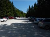
We drive to Mojstrana, then follow the signs for Vrata Valley. We continue on the toll road, which is closed to public traffic in winter, following it to the large parking lot a few minutes before Aljažev dom v Vratih.
Route description:
From the parking lot, continue along the gravel road closed to public traffic, passing Šlajmerjev dom to quickly reach Aljažev dom v Vratih.
Bypass Aljažev dom on the right and continue straight towards Triglav, Sovatna, Luknja... (right Škrlatica, bivouac at Rušje...). Continue on the poorer gravel road past the winter room to the marked junction at the famous peg (monument to fallen partisan mountaineers).
Continue straight again (left Tominšek's path) along a gentle path with fine views of Triglav and the Triglav north face. After a few minutes further, enter beech forest where the path via Sovatna branches right; continue straight towards Luknja and Triglav - path over Prag. Short ascent on cart track, then markers lead left to path approaching the bed of Triglavska Bistrica. Here the path passes the memorial to mountain victims, soon reaching the next marked junction.
Left across stream continues path over Prag; go straight on path that gradually ascends more noticeably. Path to Luknja ascends moderately for a while, higher becoming steeper and more scenic. Higher still, path through shrub and sparse forest belt, small path branches right to nearby bivouac; continue on wider path out of forest belt. Path steepens slightly, leading gradually to scree below Luknja. Path over scree slippery; at wall foot, fixed ropes assist (easy dry, useful descent). Short steep ascent beside wall, then path turns right to junction at Luknja with fine view over mountains above Zadnjica.
At Luknja turn right following signs to Bovški Gamsovec (left via Plemenice to Triglav, straight down Zadnjica), ascending grassy slopes under ridges of Pihavec and Bovški Gamsovec, usually many alpine ibex and marmots.
Path goes slightly right, crosses smooth rock slab with fixed rope. After rope, turns slightly left on grassy slopes. Ahead slightly left see small scree; marked path turns right (90°) to Bovški Gamsovec (NE) just before. Leave marked path at bend onto scree. Few metres after, cairn left of path with wands. After scree turn right on grass, ascending parallel to marked path. Grass to rocks, continue same direction. Soon notice another scree left curving up left. At end turn left to narrow gully. Before gully left memorial plaque to Tinet Mihelič. Up gully, steep with scrambling. When very narrow, climb left to grass, ascend left crossing slopes westwards. Cross narrow scree, up steeper grass (still west). Slope eases, turn right ascending north. Grass to rocks, short ascent to col Čez Kamen (2331m). At col turn left joining marked path from Kriški podi after few metres. From col path south side Pihavec west, then right slight easy ascent to summit.
Starting point - Aljažev dom 0:05, Aljažev dom - Bistrica spring 0:55, Bistrica spring - Luknja 1:35, Luknja - Pihavec 2:00.

Along the route: Aljažev dom v Vratih (1001m), Spomenik padlim partizanom gornikom (1020m), V Plazičih (1040m), Izvir Bistrice (1160m),
Luknja (1766m), Spominska plošča Tinetu Miheliču (2161m), Čez Kamen (2331m)
Photos:
 1
1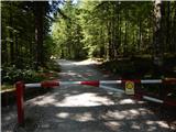 2
2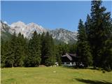 3
3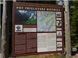 4
4 5
5 6
6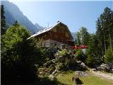 7
7 8
8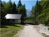 9
9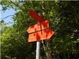 10
10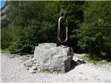 11
11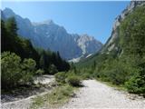 12
12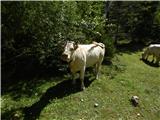 13
13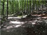 14
14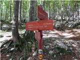 15
15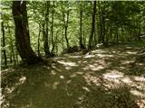 16
16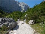 17
17 18
18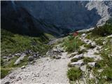 19
19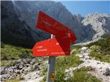 20
20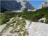 21
21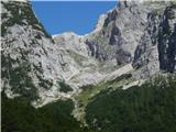 22
22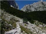 23
23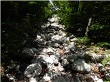 24
24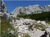 25
25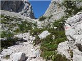 26
26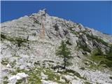 27
27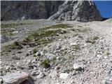 28
28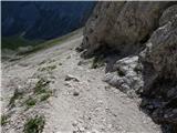 29
29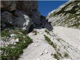 30
30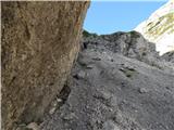 31
31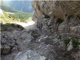 32
32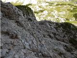 33
33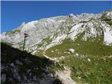 34
34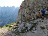 35
35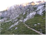 36
36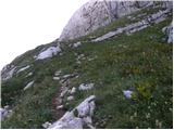 37
37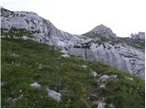 38
38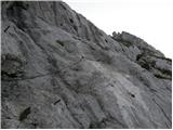 39
39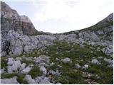 40
40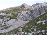 41
41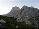 42
42 43
43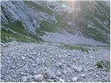 44
44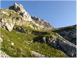 45
45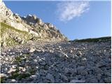 46
46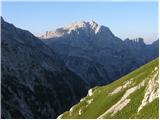 47
47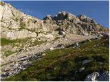 48
48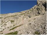 49
49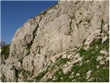 50
50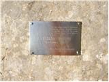 51
51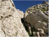 52
52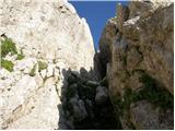 53
53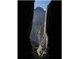 54
54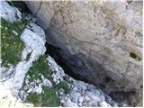 55
55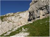 56
56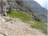 57
57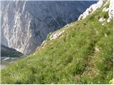 58
58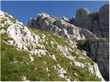 59
59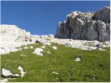 60
60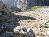 61
61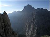 62
62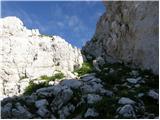 63
63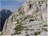 64
64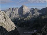 65
65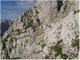 66
66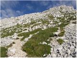 67
67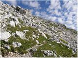 68
68 69
69
Discussion about the trip Aljažev dom v Vratih - Pihavec (via Luknja)
|
| Kriška4. 08. 2008 |
Interesting photos, I must see this "live" sometime. Very good idea with this red line marking the path!
|
|
|
|
| Bojan_A4. 08. 2008 |
Very well described trip!
|
|
|
|
| Rakar5. 08. 2008 |
To put it mildly, I find this step-by-step description of pathless trips very controversial, especially if there is any technical difficulty on the route. The orientation aids with the red line and/or GPS track have anyway been eliminated forever.
My somewhat more extensive opinion on this can be found here: http://www.hribi.net/trenutnerazmere.asp?gorovjeid=10001&id=1220
|
|
|
|
| Kriška6. 08. 2008 |
My comment on the opinion too.
|
|
|
|
| Rakar6. 08. 2008 |
My somewhat more extensive opinion posted under the title "hribi.net and step-by-step descriptions" within the subforum "General discussions" got lost. And Kriška's reply to it and my rebuttal to hers too. Maybe there are some database issues and posts are disappearing?
|
|
|
|
| Rakar7. 08. 2008 |
Completely off-topic. It took a bit to figure out what was wrong. I apologize, my opinion didn't get lost, it just "disappeared". The problem was apparently in the internal browser setting (Internet Explorer). So, if I have the largest font size set (accidentally) and the window is not set to full size (it's minimized), the entire text "gets lost" (=moves) beyond the visible frame (=downwards) and you have to "scroll" to it using the scrollbar or mouse wheel or ... Interestingly, all other topics work normally even with that setting. Maybe it's a peculiarity because this title "hribi.net and step-by-step descriptions" within the subforum "General discussions" is in first place? But thinking about it is already the webmaster's job, not mine (maybe my observation will help him). Apologies again for writing this here; the moderator can calmly delete or move it elsewhere.
Regards
|
|
|
|
| strelec195425. 10. 2008 |
The author has a good sense for describing the trail. Tomorrow I'm going on this trail and I think the description will help me quite a bit.
b.r. strelec
|
|
|
|
| Lisa12. 07. 2011 |
On Saturday (9.7.) I was on Pihavec via this path. Despite the description above, good orientation sense is needed. I was in a group of 20 hikers and we had to consult together where, how,... During ascent through the gully we used a rope. At the exit from the gully extreme caution is needed, as the path continues straight up an extremely steep grassy slope (about 5-7 meters), which is exposed on both sides. We then continued the ascent towards the notch far right by the rocks, where some climbing was needed. The ascent (far right) was quite steep and strenuous due to occasional slipping, but rock holds on the right helped somewhat. When reaching the notch, caution is also needed to avoid slipping on the smooth sloping slab, or else goodbye. 
We descended towards Kriški podi (continuing through Sovatna), where the amount of snow under the wall surprised us. First need to cross a very steep snowfield right under the wall (there were also three falls), a bit lower another one, which is not so exposed and can be crossed nicely.
The whole path was strenuous, very good condition required.
Good luck and safe steps!
Best, S.
|
|
|
|
| folpo1. 07. 2012 |
by the way, the gojzar from picture 43 is no longer there
|
|
|
|
| Moyca23. 09. 2013 |
Chamois are on the path from Zadnjica to Luknja. I met them. If I had known they were grazing, I would have brought them, but unfortunately...
|
|
|
|
| aonuk121. 10. 2014 |
After a very long time, for me again a somewhat harder tour and this for the first time on this variant. With a friend we started at five o'clock from Aljažev dom towards Luknja, where a short break - the day was already dawning. A bit further on the marked path, at the cairn (no chamois anymore) then left on pathless terrain (orientation according to the upper pictures and descriptions without problem). Below the Škrbina čez Kamen we decide to also visit Vrh nad Kamnom. We leave the backpacks and up the right gully with two short demanding jumps in between (according to descriptions difficulty I-II) and we're already enjoying the top. A somewhat harder descent back to the backpacks and again ascent towards the top of Pihavca. Weather hot, no wind, no clouds, views fantastic... The decision falls to go on the marked path (past the newly formed landslide) also to Pogačnikov dom for a beer (unfortunately the hut closed ) disappointed we continue to Dovška vratca and through Sovatna to the valley. For me a test of a full-day tour and I'm very happy and satisfied, I can still do it without problems.
Safe steps...
|
|
|
|
| Brejn25. 07. 2016 |
This Saturday visited Pihavec via the described route. No major difficulties, except steep tiring scree slopes and the first annoying step
We were surprised by the low number of visits to this mountain and according to the log we were the 10th visitors this year?!
We descended to the other side and continued towards Sovatna, weather and views top-notch.
|
|
|
|
| jaka1329. 08. 2019 |
What is the difficulty and length of climbing through the gully?
|
|
|
|
| ločanka29. 08. 2019 |
You can go to the left under the gully
|
|
|
|
| darinka429. 08. 2019 |
Above all it's pathless. You won't see a single cairn the whole way. If you mean from Miheličeva plošča to the summit, that seems to me the easiest part, because then you reach the path below the summit.
|
|
|
|
| darinka431. 08. 2019 |
Last year we went for the first time just by the description. And at the bottom we went too far left. Then we searched for a while for the right approach to Miheličeva plošča and found it. That initial part is quite demanding, especially when you're doing it for the first time.
|
|
|
|
| ljubitelj gora5. 07. 2020 |
Today 5.7 started around 2.30 from Vrata towards Luknja and through the gully to Pihavec. The gully has two short jumps rated II degree, so no one is surprised that it is only demanding pathless terrain. At the top the sun rose soon after arrival around 5.20. Descended towards Pog.dom, snowfield still there, ice axe useful, there were steps, for crampons if it freezes it will be hard to descend only with ice axe.
|
|
|
|
| djimuzl5. 07. 2020 |
The path Pogačnikov dom - Pihavec is closed, by the way.
|
|
|
|
| grifomatik8. 07. 2020 |
Yes, it's been closed for 4 years already. I noticed too late.
The snow patch is a bit tricky, but can be bypassed. However, it's not for someone who doesn't have at least basic climbing skills.
|
|
|
To post a comment you must log in:
If you do not yet have a username, you must first
register.