Aljažev dom v Vratih - Stenar (via Sovatna)
Starting point: Aljažev dom v Vratih (987 m)
| Latitude/Longitude: | 46,41280°N 13,84660°E |
| |
Route name: via Sovatna
Walking time: 5 h 15 min
Difficulty: partly demanding marked way
Elevation gain: 1514 m
Elevation difference along the route: 1520 m
Map: Triglav 1:25.000
Recommended equipment (summer): helmet
Recommended equipment (winter): helmet, ice axe, crampons
Views: 113.031
 | 9 people like this post |
Access to starting point:
We drive to Mojstrana, then follow the signs for Vrata valley. We continue along the toll road, which is closed to public traffic during winter, following it to the large parking lot located a few minutes before Aljažev dom v Vratih.
Route description:
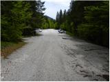
From the large parking lot in Vrata valley we continue along the gravel road, reaching Aljažev dom v Vratih in a few minutes' walk.
From the hut we continue straight towards Triglav, Stenar and Kriški podi (right Škrlatica) and proceed along the wide tourist path. The path ahead ascends barely noticeably through a strip of forest, bypassing the winter bivouac on the right, then the forest thins and after a few more minutes we reach the large wedge (monument to fallen partisan mountaineers). From the monument we go straight (left Tominškova pot) along the path that gradually re-enters the forest and higher up leads to a marked junction, where we turn right towards Pogačnikov dom (straight to Triglav and Luknja). From the junction the path steepens through beech forest (area called Bukovlje), leading us just above 1300 m a.s.l. to a pleasant spring that dries up in dry periods. A few more minutes through forest or higher scrub follow, and the path emerges from the forest at the foot of Sovatna, joined by an overgrown path from the bivouac below Luknja.
From here the path becomes steeper and more scenic. Offering fine views of Triglav's north face, it leads higher to a short slightly exposed section requiring extra care when wet. The path then levels slightly but ascends relatively steeply. Scree ascent follows, the valley narrows, and we reach a short rocky step climbed using reliable fixed protection.
Above the step the slope flattens; the path crosses a series of basins where ibex herds are often seen. Higher it switches to the left valley side, traversing a broad shelf slightly exposed in parts. After a few dozen paces we reach a marked junction at Dovška vrata.
We continue right to Stenar and Križ (left Bovški Gamsovec and Pogačnikov dom) on an initially easy then steeper path to the junction below Stenarska vratca.
Right again (left Križ) on a panoramic path, soon joined higher by an unmarked route over Stenarska vratca. We cross scree with views of Triglav, Bovški Gamsovec, Pihavec and Trenta valley to Stenar's steep slopes. The path ascends steeply through sculpted rock, turns sharply left, flattens after some 10 m. Here (or 10 m earlier) an unmarked scramble to Spodnji Stenar branches right; we stay on the marked path steepening again. About 15 minutes on the summit ridge bring us to the 2501 m peak.
Starting point - Aljažev dom 0:05, Aljažev dom - spring in Bukovlje 1:25, spring in Bukovlje - Dovška vrata 2:30, Dovška vrata - Stenarska vratca 0:20, Stenarska vratca - Stenar 0:55.

Along the route: Aljažev dom v Vratih (1001m), Spomenik padlim partizanom gornikom (1020m), V Plazičih (1040m), Izvir v Bukovlju (1317m), Bukovlje (1418m), Dovška vrata (2176m), Stenarska vratca (2288m)
Photos:
 1
1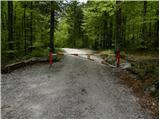 2
2 3
3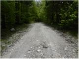 4
4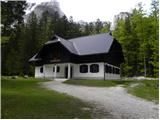 5
5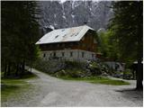 6
6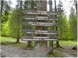 7
7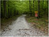 8
8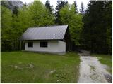 9
9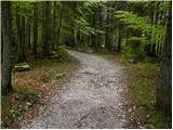 10
10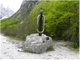 11
11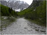 12
12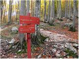 13
13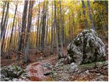 14
14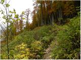 15
15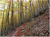 16
16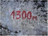 17
17 18
18 19
19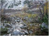 20
20 21
21 22
22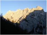 23
23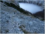 24
24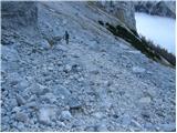 25
25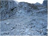 26
26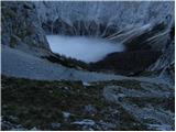 27
27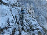 28
28 29
29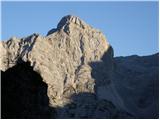 30
30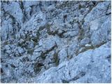 31
31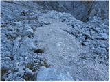 32
32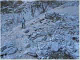 33
33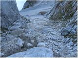 34
34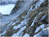 35
35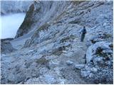 36
36 37
37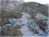 38
38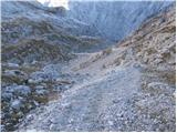 39
39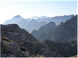 40
40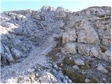 41
41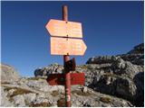 42
42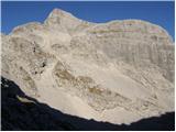 43
43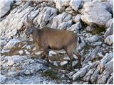 44
44 45
45 46
46 47
47 48
48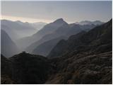 49
49 50
50 51
51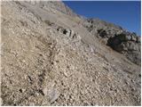 52
52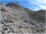 53
53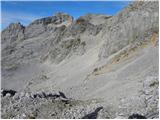 54
54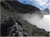 55
55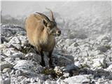 56
56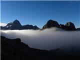 57
57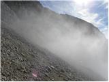 58
58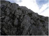 59
59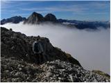 60
60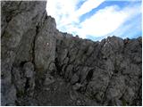 61
61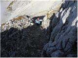 62
62 63
63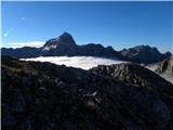 64
64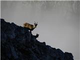 65
65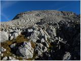 66
66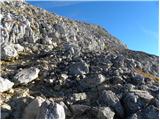 67
67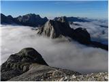 68
68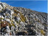 69
69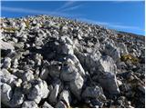 70
70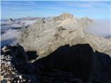 71
71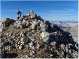 72
72 73
73
Discussion about the trip Aljažev dom v Vratih - Stenar (via Sovatna)
Show older messages
|
| Gost27. 08. 2007 |
I report that the trail over Sovatna is very poorly marked. Up to Dovška vrata the trail is still visible, from there to Stenar I would advise the markers to mark the trail better. I also wonder why they don't remove the wire on the trail from Dovška vrata to Stenar.
Best, Tina.
|
|
|
|
| Gost28. 08. 2007 |
On Sunday 26.8.2007 I was on Stenar and I think that there are really too few markers from Dovška vrata to Stenar, but the path is quite well trodden, so there were no problems with orientation. But I think that safety devices are really not needed anywhere. Well, that's just my opinion. Best regards, S.
|
|
|
|
| sonce330. 07. 2008 |
I'm curious, how much walking time is there from the top of Stenar to Pogačnikov dom? Thanks and good luck!
|
|
|
|
| nekdo130. 07. 2008 |
I think it's 2 hours in the opposite direction (?) so it should be about 1 - 1.30 h (?)
|
|
|
|
| Reny5. 09. 2008 |
I also think there were enough markers via Sovatna, from Dovška vrata to the summit it seemed more complicated to me... we went a bit our own way and reached a fork where there was no signpost.. thanks to the maps I carry with me to orient a bit and recognize the surrounding peaks. Despite the longer tour, I recommend a visit, you see plenty of chamois and watch the crowd on Triglav...
|
|
|
|
| capin6. 09. 2008 |
Today I went to Stenar via Stenarska vratca. Markings are no longer there, they were very rare anyway and have faded. Below the vratca, the rocks are crumbly and slippery so you have to be very careful. When I descended to the path coming from Dovška vrata, I spent quite some time looking for the path to the top of Stenar. There was also fog, so orientation was even harder. There are really few markings, but in good weather the direction is quite clear. Via Sovatna there are plenty, you can't get lost there. Despite the fog and wind, a nice tour, and the descent via Gamsovec and Luknja is even nicer.
|
|
|
|
| maremarcus9. 07. 2010 |
Markings as of yesterday are good from Vrata valley over Sovatna to Dovška vrata. From Dovška vrata onwards they are poor, as you reach Stenarska vrata before the path to the summit of Stenar. Also on the scree to Stenar there are 2 snow flanks that are frozen in the morning and crampons are recommended when crossing. Below the summit and summit is dry and nice views around.
|
|
|
|
| Parkeljc11. 07. 2010 |
Today I went from Vrata to Triglav, but soon due to the crowd on the path I changed my mind and turned to Sovatna towards Stenar. From Dovška vrata the markings are really poorly visible or covered by snow patches. With a bit of orientation and concentration it's not hard to reach the summit. I was up in 2.5 hours, then also to Bovški Gamsovec and back the same way (Dovška vrata, Sovatna, Vrata). Crampons are not needed! Fantastic weather. For the whole tour I took 5.5 hours.
|
|
|
|
| peter223. 09. 2010 |
Visited Stenar and Bovški Gamsovec yesterday.
Nice autumn day, lots of mountain animals and wonderful views.
Pictures are here: http://www.petersfoto.si
|
|
|
|
| vespa2. 11. 2011 |
Has anyone been to Stenar or the hills around Kroške pode these days? Any information on the path, snow and other conditions would be very welcome.
|
|
|
|
| vespa2. 11. 2011 |
There are so many errors in my previous message that I have to correct - I meant of course Stenar and Kriške pode.
|
|
|
|
| urbancek26. 11. 2011 |
Yesterday there was good visibility and I think I could see Monte Pelmo from the summit, but I'm not sure because I really don't know the Dolomites (it was such a distinctive mountain shape, somewhere in line with the Poljski Špiki). Can anyone confirm my suspicion?
Best regards!
|
|
|
|
| IgorZlodej26. 11. 2011 |
The beautiful distinctive pyramidal mountain visible is Antelao, to its left is Monte Pelmo, even further left Civetta. I have already posted a picture of this trio several times . .
|
|
|
|
| urbancek26. 11. 2011 |
@Igor: Well, I checked all three mentioned mountains a bit on Google and there's no doubt, I saw Monte Pelmo, because you don't forget such a shape... Probably something else is visible too, but this one caught my eye this time...
Interesting mountain!
Best regards!
|
|
|
|
| Janiel749. 08. 2012 |
How is the marking of the path to Stenar? I read old comments and all mention this problem??? Thanks
|
|
|
|
| Flora19. 08. 2012 |
Eyes peeled and no problem. To Dovskih vrat path is clear, then right and watch for right branch, about 20-30 min from Dovskih vrat. But terrain guides you. Good luck.
BTW, I always carry a map, even to a mountain I've been to before.
|
|
|
|
| NINICA10. 08. 2012 |
On Saturday I went to Stenar via Sovatna! The path is normally marked, no problem at all.
|
|
|
|
| urbancek10. 08. 2012 |
I don't know what's poorly marked on this path...
|
|
|
|
| Janiel7410. 08. 2012 |
Checked the marking status to Stenar and Križ, and I have to say, everything is very very easy to find. Nice circular tour Vrata-Sovatna-Stenar-Križ-Bivak IV-Vrata
|
|
|
|
| LidijaJesih10. 08. 2012 |
Janiel74: Where didn't you overtake us? we didn't meet despite the same trail. LP we didn't meet despite the same trail. LP
|
|
|
|
| Janiel7410. 08. 2012 |
I saw you on Križ from Stenar... but I ate both on Stenar and even further on Križ up there I chatted with some Austrians To Vrata I needed from Križ 1.15h when did you get to Vrata?
|
|
|
|
| Janiel7410. 08. 2012 |
Pardon 2.15h typing error. So as not to spread nonsense
|
|
|
|
| LidijaJesih10. 08. 2012 |
I don't quite remember the time, around two probably. Maybe you passed the bivouac, we took a longer break there too. We met the Austrians on the way too. Despite the typing error you were fast. If you saw, at the junction it's marked to Vrata 4 hours. Olympic day, then.
|
|
|
|
| tilko3214. 06. 2013 |
and does anyone perhaps know from previous years if there's still a lot of snow on the path over Sovatno at the beginning of July thanks for any info
|
|
|
|
| IgorZlodej14. 06. 2013 |
Previous years there wasn't any, this year there's already snow in the valley
|
|
|
|
| tilko3219. 06. 2013 |
yeah I know because of the avalanche right from Stenar
|
|
|
|
| smooch1. 08. 2013 |
Hi, I'm interested if anyone has recently gone on this path - is everything dry yet? Thanks and good luck with all your endeavors!
|
|
|
|
| ms_primoz1. 08. 2013 |
Through Sovatno everything is dry, three snow patches higher up when you're already ascending to Stenar, but they pose no danger, and besides the snow is soft. Once again, no danger at all. Good luck and safe steps
|
|
|
|
| smooch1. 08. 2013 |
Thank you very much! Have a safe return journey.
|
|
|
|
| skočnik123. 08. 2013 |
Has anyone found poles? One pair of nordic walking poles, and one green pole. We lost We lost
|
|
|
|
| nezica18. 09. 2013 |
What's the current condition? Could we still get up nicely over the weekend? How much snow is there?
|
|
|
|
| malimiha28. 03. 2017 |
Hello, has anyone been up there in the last few days? What are the conditions like? Thanks and best regards
|
|
|
|
| Jani33328. 05. 2017 |
Hi,
I'm also interested in what the conditions are like?
Has anyone been up there lately?
Thanks
Regards J
|
|
|
|
| tango1. 11. 2017 |
The path via Sovatno is fine, just a little snow in a few places, which poses no problem. After the junction to Križ (left) continuing towards Stenar there is snow only on that crossing under the wall to the summit structure, caution is not superfluous, but no serious issues. Otherwise quite a rush to the top!
|
|
|
|
| franjo6615. 06. 2018 |
What are the conditions?
Thanks for the reply...
Regards
|
|
|
|
| funnyboy15. 06. 2018 |
There's still some snow patches up there, the traverse under the summit is still completely under snow. Winter gear highly recommended
|
|
|
|
| moowy16. 07. 2018 |
Is there still any snow on this trail?
Thanks for the answer and safe steps to all.
|
|
|
|
| Tamt28. 07. 2018 |
There's still one snowfield under the walls, but it ends right next to the path, so no problems.
|
|
|
|
| ucakakla11. 06. 2019 |
Hello,
I'm interested in the path from Vrata to Stenar regarding snow conditions?
Thanks and best regards.
|
|
|
|
| KLAN13. 11. 2019 |
Yes, avalanche danger, and on Stenar it's of course for slipping because if you don't have crampons you slip quickly like on the glacier at Rokavi some years ago, otherwise nothing special, the track is probably already made, snow as it is, good luck.
Lp L.
|
|
|
|
| turbo13. 11. 2019 |
Another illiterate You probably don't even know yourself what you wanted to say.
|
|
|
|
| mirank13. 11. 2019 |
Google Translate doesn't work for me either
|
|
|
|
| Lapuh20715. 11. 2019 |
It works for me, but with this message it gets mixed up
|
|
|
|
| kolpa13. 07. 2020 |
Hello!
Please provide a time estimate for the two-day hike: Vrata - Bivak IV - Škrlatica - Dolkova špica (via Rdeča škrbina) - Križ - Kriški podi (Pogačnikov dom - overnight) - Stenar - Bovški Gamsovec - Vrata (via Sovatno). I will have my wife with me and won't hurry - normal hiking pace. Thanks for the answer and safe steps!
|
|
|
|
| Domch13. 07. 2020 |
First day 10-12 hours. Second day 8 hours.
|
|
|
|
| a7a7a7a1013. 07. 2020 |
Hi, wondering if the path is suitable for a 1-day tour!
|
|
|
|
| Enka2. 08. 2020 |
The path over Sovatno and further to Stenar is well marked, but from Dovška vrata onwards there are quite a few "shortcuts" and branches, so you need to follow the signs. Increased traffic is quite noticeable, all scree fields are finely churned up.
|
|
|
|
| Šmarnagora6. 08. 2020 |
Is the path suitable for a dog? Thanks for the info.
|
|
|
|
| ppegan6. 08. 2020 |
Yes, for a dog that is used to moving in the mountains and for which prolonged walking on scree and rough rocks is no problem. I was with my Dalmatian on Stenar the weekend before last. She managed the path without issues, and even the close encounter with an ibex went peacefully, considering I never leash her (we went around it) - she has been hiking since she was a puppy, and she is also very obedient and attentive, so she's a great dog. However, this path is quite exposed to the sun (once you leave the forest), so that can also be a problem. We two were lucky because it was cloudy and foggy, or it cleared up only during the descent. Good luck
|
|
|
|
| Enka6. 08. 2020 |
On a sunny day this is really torture for a dog, and I have a dog myself who often went hiking with me when she could still manage. So I'm not lecturing, but really advising from the heart. You also need to watch that the dog doesn't trigger rocks, as there are plenty of opportunities on this path, so it must be used to hiking in that sense too.
|
|
|
|
| Šmarnagora6. 08. 2020 |
Hi, big thanks to both for the info!
Of course it depends on the breed/habituation of the dog etc... I was more interested in whether there are any cables and pegs in between where the dog couldn't go.
|
|
|
|
| ppegan6. 08. 2020 |
There are cables, and also two or three rock jumps, but mine managed it, she's just a big dog with good thrust and such "obstacles" are no problem for her. But nowhere is there a vertical wall to climb over. So if the dog is used to all that, you won't have problems. Good luck
|
|
|
|
| Enka6. 08. 2020 |
The only cables are over Sovatno, a short section. When I went up, someone was descending with their young medium-sized dog, which went past there without any problems. A few years ago we also descended with two dog heroes, at that time the dogs bypassed that section on steep scree.
|
|
|
|
| ciklama8. 07. 2021 10:37:02 |
I'm interested if there's still any snow on the path through Sovatno towards the top of Stenar, and also for the descent past Buvak IV?
|
|
|
|
| Lazo24. 09. 2021 20:46:26 |
|
|
|
|
| Kafetarca2. 09. 2022 21:15:49 |
Hello! If going from Vrata over Sovatna to Stenar, is it worth detouring to Kriški podi on the way back, or is it too far for one day?
|
|
|
|
| simon162. 09. 2022 21:33:11 |
Both can be hiked in 1 day and even another summit if willing. Say Križ or Bovški Gamsovec and then to the valley via another path (past bivouac IV or over Luknja).
|
|
|
|
| Kafetarca3. 09. 2022 04:32:55 |
Thank you for the reply
|
|
|
|
| tango12. 09. 2022 20:18:50 |
Today's day on the path over Sovatna wasn't too hot. Ideal temperatures, exceptional visibility, individual clouds added picturesqueness. Path in good condition, few hikers, chamois hidden from our eyes. To avoid repeating Sovatna, from Stenar we headed to Križ and down to bivouac at Rušje, beautifying the day with 1640 m ascent.
|
|
|
|
| Engis21. 09. 2022 16:51:15 |
Greeting, does anyone know the condition of the path over Sovatna to Stenar? Probably no snow on the path? Thanks!
|
|
|
|
| Engis26. 10. 2022 14:30:36 |
Hello, repeating the same question today. If anyone knows and is so kind. Thanks
|
|
|
|
| Krzo992. 07. 2024 09:34:27 |
Hey, does anyone know how the path condition is at the beginning of July? Is winter gear still needed?
|
|
|
|
| Klinar273. 07. 2024 19:19:32 |
It's possible there's still a snow patch below the summit, as that one lasts quite a while. Winter gear is needed for it since it's very steep. But I don't know if it's dry now or not
|
|
|
|
| user031013. 07. 2025 22:10:37 |
Oh, how would you rate the difficulty comparison with Bovški gamsovec over Luknja
|
|
|
|
| Enka14. 07. 2025 09:48:52 |
About the same, nothing special. Maybe a tad easier. Over Sovatno some shorter annoying scree bit, simple short fixed rope, on Stenar scree here and there. In short, if Gamsovec went, so will Stenar.
|
|
|
|
| S57S28. 09. 2025 09:49:13 |
Hiking-radio amateur 4K Video from this path you can
watch here:
https://youtu.be/jz1N43yNytA
As others have mentioned, there is quite a lot of scree on Sovatna. Caution on descent. Trekking poles will be very helpful. Good luck.
73, Aleksander, S57S
(73 in radio amateur terms means best regards)
|
|
|
To post a comment you must log in:
If you do not yet have a username, you must first
register.