Železna Kapla / Bad Eisenkappel - Boschitzberg (Türkenkopf Klettersteig)
Starting point: Železna Kapla / Bad Eisenkappel (555 m)
| Latitude/Longitude: | 46,49670°N 14,58310°E |
| |
Route name: Türkenkopf Klettersteig
Walking time: 3 h 30 min
Difficulty: extremely difficult marked way
Via ferrata: D/E
Elevation gain: 673 m
Elevation difference along the route: 675 m
Map: Karavanke - osrednji del 1:50.000
Recommended equipment (summer): helmet, self belay set
Recommended equipment (winter): helmet, self belay set, ice axe, crampons
Views: 54.761
 | 4 people like this post |
Access to starting point:
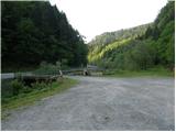
Over the border crossing Jezersko or over Pavličevo saddle, we continue driving to the end of the settlement Železna Kapla / Eisenkappel, where we park at the abandoned joinery workshop on the left bank of the river Bela. Above the parking lot, a fortification (Turkish guardhouse) with a flag can be seen.
Route description:
From the parking lot, we head in the direction of the river along the joinery workshop, where we spot steel cables and pegs.
The initial traverse (C) soon ascends vertically (C/D), with progress aided only by the steel cable and the occasional peg. The wall is continuously vertical. A long traverse (C) to the left follows, taking us from the vertical into a pleasant grove where we can rest. Immediately, the next demanding section begins, bringing us to a short, slightly overhanging rib (C/D), followed by a vertical pitch (C) directed slightly to the left, ending in the grove. Here we are at about halfway along the climbing route. Ahead lies the most difficult section, starting with a vertical pillar (C), after which the hardest spot begins. In the pronounced overhang (D/E), we climb leftward and upward, aided by a few sparingly placed pegs (quite far apart – a challenge for shorter mountaineers). Here, most of the weight is on the arms, and for those with less strength or climbing technique, this section can be impassable. Extremely demanding, especially, is clipping the carabiners of the via ferrata set while holding the steel cable with one hand. The route turns right, and the difficulty does not ease until the end of the traverse to the right. The use of a short rope or sling for a possible rest in the middle of the hardest part is highly recommended, as progressing through the most difficult part without a break is possible only for very strong climbers. The worst is behind us; only a few shorter moderately difficult spots (C) in well-featured rock follow, after which the path traverses forested slopes and soon the steel cables end too. It takes a good two hours of ascent to here (end of the climbing route). From here, we can continue to Božičev vrh (following the Austrian markers uphill to the right) or descend to the starting point.
Detailed topo map description can be found at http://bergsteigen.at/pic/pdf/2140_Topo_80d228b2-3713-4335-b373-bb8bb658dfba_tuerkenkopf.pdf

Photos:
 1
1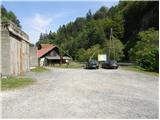 2
2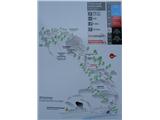 3
3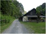 4
4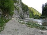 5
5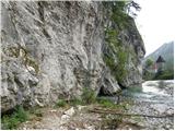 6
6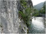 7
7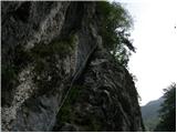 8
8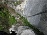 9
9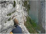 10
10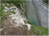 11
11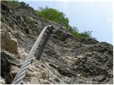 12
12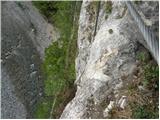 13
13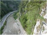 14
14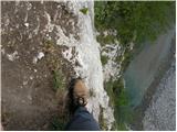 15
15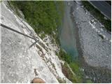 16
16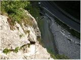 17
17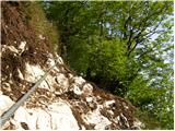 18
18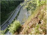 19
19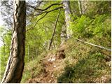 20
20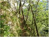 21
21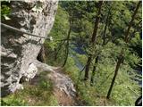 22
22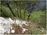 23
23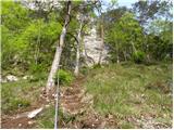 24
24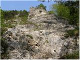 25
25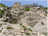 26
26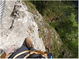 27
27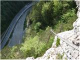 28
28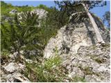 29
29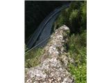 30
30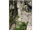 31
31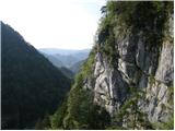 32
32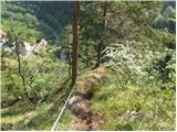 33
33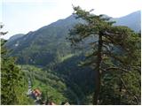 34
34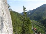 35
35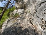 36
36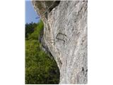 37
37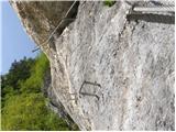 38
38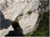 39
39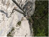 40
40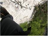 41
41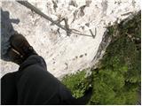 42
42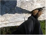 43
43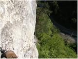 44
44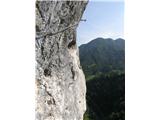 45
45 46
46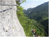 47
47 48
48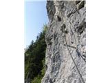 49
49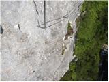 50
50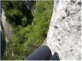 51
51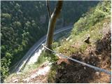 52
52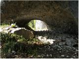 53
53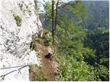 54
54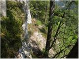 55
55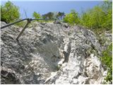 56
56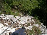 57
57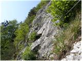 58
58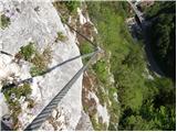 59
59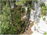 60
60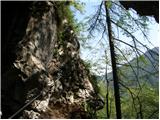 61
61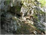 62
62 63
63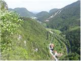 64
64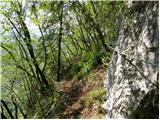 65
65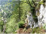 66
66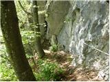 67
67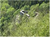 68
68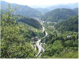 69
69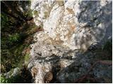 70
70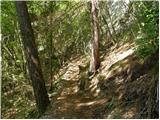 71
71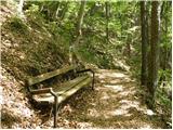 72
72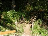 73
73 74
74 75
75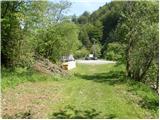 76
76
Discussion about the trip Železna Kapla / Bad Eisenkappel - Boschitzberg (Türkenkopf Klettersteig)
Show older messages
|
| geppo10. 08. 2010 |
If you don't see the point, Bojan A, then stop bothering with it.
You've already dragged yourself through quite a few demanding vias (all honor to you!!) and you're still wondering?? find your own satisfaction...
Lp Zlatko
|
|
|
|
| Bojan_A10. 08. 2010 |
I've already concluded with the vias. Now I'm going climbing.
|
|
|
|
| Bojan_A10. 08. 2010 |
Well, anyway, satisfaction is bubbling in me just because I'm in the mountains. And wherever it may be. In the mountains everywhere is beautiful. 
|
|
|
|
| penzionist13. 08. 2010 |
On Monday my sister and I went to check how these modern via ferratas look in practice. There was no point in questioning the sense, instead we put together a short video. It is located at
http://boris.slo-alp.com
|
|
|
|
| grega_p14. 08. 2010 |
At the most difficult part of the ferrata D/E, there is a skeleton with a helmet on its head placed in the wall as a reminder of the difficulty. I really don't know what it's doing there, instead of a sign with warnings at the start of the path. It's not at all pleasant to spot it when holding the cable with one hand and chimneying with the other.
Otherwise, once again emphasis - extremely demanding ferrata, mainly due to the required arm strength. The footholds can also be dangerous, as today when it was slippery from yesterday's rain.
I agree with Bojan, everywhere is beautiful in the mountains, even if there's a bit too much of this iron. Too much of anything harms, as we know.
Enjoy and be smart on this ferrata!
|
|
|
|
| klm15. 08. 2010 |
Less trained users of this ferrata should take a prusik with them for belaying during strength sections before key parts. Otherwise, the ferrata is routed like other Carinthian ferratas (Walter-Mory Klettersteig in Peč, Cjajnik or in Ročica gorge (Rotschitza)) forcibly, without harder passages than shown on the path. That's the trend - Austrian tourism, perceived in a completely different way than us. They have degraded nature in many ways already, now they discovered a new niche. Good that ferratas are in valleys, although in other federal states they do exactly that. Until last year, Cjajnik and the above-mentioned ferrata under Peč had primacy of the most demanding secured climbing paths, now this described path bears that title. But for how long? Austrians expanded their difficulty scale from max E to F/G, thus now leading Italians and Germans who have only six grades. One thing is even more controversial: ferrata popularity is high, but almost no one knows the number of accidents is equally high, some fatal ones already, but no one talks about it. Introverted and degraded Austrian nation successfully silences it.... otherwise, Bojan, between these forced ferratas where you more or less always grip cables, and real climbing there is a big difference. Unfortunately, many hikers don't feel this difference, who probably these paths give the feeling they climbed something, a few levels above classic hiking. However, this is completely wrong, far from real climbing, genuine contact with the rock...
|
|
|
|
| Bojan_A15. 08. 2010 |
@ klm: I have already climbed (e.g. in Stena) and I know well that there is no comparison between climbing and "via ferrata".
|
|
|
|
| klm15. 08. 2010 |
Good Bojan. I know you know. Recently you have done say three Austrian via ferratas, two of which are in our immediate vicinity. In short, if you think a little, how much actual contact with the rock did you have? Rather little or in other words, more or less you were pulling on the cable all the time. I will try to specify the purpose of writing, namely the lines written above, of which I am the author, were not aimed at you personally, nor are these, but I am just expressing my opinion on such practices by our northern neighbors. In short, by creating the path on Cjajnik, they have destroyed say at least five extremely beautiful routes that required climbing from III to V difficulty. They did something similar before in Škocjan (Kanzianiberg), where they also destroyed about five extremely beautiful sport climbing routes (from 6b to 8b?!?). This is only in our immediate vicinity, in other countries that are much more tourist-attractive, the situation is even worse. Interestingly, the initiators are local tourist associations. No one thinks about what environmental degradation this entails: on Cjajnik and on Turška glava there are say 900 meters of cables, plus several hundred kg of pegs and bolts...
|
|
|
|
| mikk23. 08. 2010 |
Today I also climbed this via ferrata and must say nothing difficult, compared to "Fallbach klettersteig" which I climbed yesterday.
True though that via ferratas cannot be compared to climbing, since sections D/E or E are well above grade 5 in climbing... at least that's how it seems to me.
|
|
|
|
| mikk25. 08. 2010 |
Aha... and the climbing time should be corrected, because 3h30 is really too much for this via ferrata.
|
|
|
|
| JanezJe27. 08. 2010 |
A few days ago I went over this via ferrata, and I was a bit disappointed with what I saw. The route is, mildly put, forced. The setter of this route will have to work hard to ensure safety since the rock in places where the pegs are placed is loose, the cable attached to pines etc. Unfortunately commerce does its thing. Ascent time 38 and descent 12 minutes.
|
|
|
|
| geppo27. 08. 2010 |
Well, all via ferratas are routed a bit forcefully...
You were so fast that I didn't even notice you..
Madonna, how did you even notice all those shortcomings?
Lp
|
|
|
|
| andrejp2. 09. 2010 |
Yesterday after work we went out of curiosity to see what's in the mentioned via ferrata. Yeah, pulling on the aids, a bit of adrenaline, but otherwise can't compare to real rock climbing. We spent less than an hour taking photos and looking around, although the view is mostly limited to the road and river and nearby hill.
Then a quick stop at Češka koča for jota. The warden Tone said that the path towards Koča and also towards Mlinarsko sedlo is quite icy in places
Lp Andrej and Janez
|
|
|
|
| vetrc20. 09. 2010 |
...meaningless dragging, there should be a sign with warnings, too much iron, forcibly routed, degraded nature, introverted degraded Austrian nation, this is completely wrong, destroyed 5 routes, no view, shortcomings, ascent 38, descent 12 minutes, correct the climbing time, nothing difficult,
the path is not cleaned... Slovenes are not capable of making even one via ferrata, they philosophize, then graze in Austria, Italy, criticize, pretend to be smart, arrogant, puffed up, conceited know-it-alls who think they know everything!
|
|
|
|
| klm21. 09. 2010 |
Vetrc, all good. You made a nice collage, somewhat avant-garde, even with some futuristic elements... you know where that movement came from and who identified with it the most.
Since you borrowed some of my phrases in the collage, I allowed myself some remarks: I certainly didn't philosophize, I assume you don't know what philosophizing actually means, look up what an introverted degraded Austrian nation actually means from a socio-anthropological perspective; namely, you obviously have too little contact with them;
Slovenes would be capable and could make such secured climbing routes without problem if they decided so, but fortunately no such decision was made, although about a decade ago they quietly considered it too.
My opinion on this kind of "climbing fun" I already gave in the two paragraphs above, under which I signed, and I avoid them from afar; Such ones in the Karawanks - only in the Karawanks - I visited due to professional obligation and nothing else.
On the forum we strive to be as little offensive to each other as possible, so I don't find it excusable, despite disagreement with the mentioned opinions, that you characterize us as arrogant, conceited, haughty. In addition, it seems to me that you don't know the actual meaning of the mentioned words.
|
|
|
|
| aonuk12. 12. 2010 |
In summer I tried the via ferratas in Železna Kapla and I don't know what's so terribly wrong. What would be so wrong if we had some via ferratas here too? First of all, people wouldn't cross the border so much and no great damage is done to the rock itself. Are only those who decide (who are they?) against it, or as usual, there's no money?
|
|
|
|
| JusAvgustin2. 12. 2010 |
I am firmly against via ferratas here , I hope there are more people with similar opinions than those who would drill pegs and brackets into every rock , I hope there are more people with similar opinions than those who would drill pegs and brackets into every rock , otherwise winter is coming, let's leave it until the dry season , otherwise winter is coming, let's leave it until the dry season
|
|
|
|
| penzionist2. 12. 2010 |
Some are firmly against via ferratas, others firmly against ski tourers, third firmly against bolts, fourth against climbers, fifth against hikers, sixth against day-trippers, seventh against ....
In today's society, obsessed with tolerance and respect for others and the environment, it's hard to exist without being a thorn in someone's side. If I go climbing or ski touring, half of Slovenia is horrified (madmen, irresponsibly killing themselves..), if I go along some cable, the "conscious mountaineers" are horrified and if I'm at home in the armchair with a beer in hand, there's again plenty of outrage.
Every activity anywhere has its consequences and I'm really curious if those "firmly against" are truly completely clean? If you hammer a peg into a crack, a trace remains. If you hammer a peg into the same spot 100 times, the crack becomes unusable (very likely already after 3 pegs) and the rock (nature) permanently damaged. If you drill a bolt, it's equally a major intervention (12 mm diameter) into nature. So it's to be expected that "firmly against" don't hammer pegs, don't climb bolted routes and don't trample mountain herbs and scare animals with their presence and destroy nature.
No extreme is good, neither the "firmly against" nor the "firmly for". There's enough space for everyone, if we just have a bit of common sense. Otherwise it can easily happen that everything is forbidden for everyone (except some exceptions of course). In the end, there are say only 50,000 hikers and even if we double that figure, it's barely 5% of the Slovenian population. How many then support the "pure alpinists"?
|
|
|
|
| geppo3. 12. 2010 |
Via ferrata yes/no?
near my home there's an 80m via ferrata under construction. Opening soon (probably would already be, if snow hadn't covered it). Other details are still a secret....
I'm looking forward to it!
LP
|
|
|
|
| aonuk13. 12. 2010 |
Bravo (pensioner) I completely agree (I'M IMMEDIATELY IN A BETTER MOOD).
Geppo, will you post when it's time for that secret news?
LP
|
|
|
|
| geppo3. 12. 2010 |
Guys, I will, but I'm still bound by the vow of silence....
|
|
|
|
| lepenatka3. 12. 2010 |
It's not a complete secret. Although I'm not bound by the vow of silence, I'll stay quiet
|
|
|
|
| tonek74. 12. 2010 |
there will still be freedom here
the last comments convince me of that, it's not only narrow-mindedness at home in this country we are also open people who allow living also to those who think differently
so don't worry if there will be via ferratas here, but go and walk them because the essence is that we are in nature, right
hurrah
|
|
|
|
| Sam.volk4. 12. 2010 |
Via ferrata enthusiasts don't care much about nature.
|
|
|
|
| oakley_sf4. 12. 2010 |
oh what mothers... a little care for nature, but because there's a peg in the rock?? there are worse things than via ferratas, like trash and I won't list more.................etc...
|
|
|
|
| VanSims9. 02. 2011 |
The idea for comparison didn't grow in my garden but I'm passing it from another mountaineering forum and another thread, adapted appropriately:
So, the debate on via ferratas, YES or NO is similar to the debate on porn on TV, YES or NO. If you don't like it, don't watch.
Porn is also supposedly harmful because it ruins morals,... BLA BLA.
|
|
|
|
| 246622. 05. 2011 |
was on the via ferrata in Železna Kapla today and found that the via ferrata is excellent, unique, could be a bit longer. If you want to climb such a via ferrata you have to do something for yourself after work, not sit in the pub all afternoon or sleep all afternoon. Weather was great too. We lack such vias around here.
|
|
|
|
| meta.nacy31. 07. 2011 |
2466, I join your description of the Turkish Head, but just a small correction - it's divine, short but sweet!
|
|
|
|
| Marin1. 08. 2011 |
I have climbed this ferrata 3 times, I won't say scaled it, so there won't be any complaints from "professional climbers" Personally, I wouldn't classify the ferrata among the easier ones, because the difficulty reaches D in some sections. I hope that something will start being done on ferratas in Slovenia as soon as possible.
Best regards
|
|
|
|
| neph25. 08. 2011 |
Yesterday I climbed the mentioned via ferrata for the first time. It is routed quite forcibly in certain sections to gain "sporty" character. Otherwise, as a via ferrata it is nice, in some parts some arm strength is needed.
|
|
|
|
| keber11. 09. 2011 |
As new as it is interesting that rock is already quite worn in many places especially with dirt which partly made me hang yesterday on via ferrata set on cable. Otherwise first time with buddy, interesting, great secured, excellent for arm and balance training, extremely exposed but quite brutally routed ferrata. Gurtna really useful for resting in hardest part. Some climbed up in climbing shoes excellently.
|
|
|
|
| geppo1. 09. 2011 |
For climbing shoes good to have cloth or rag to wipe soles smeared with dirt several times on the way.
|
|
|
|
| Keko9. 09. 2011 |
I see that a debate has flared up about these extreme vias ferratas and since a similar, but shorter, one was also opened in Slovenia (Vinska gora - Gonžarjeva peč) I'm interested in a difficulty comparison. Let me remind you that Gonžarjevka already claimed its blood toll shortly after opening. I tried it myself and can say that it really is just pulling along the cable.
|
|
|
|
| geppo9. 09. 2011 |
I often read that vias ferratas are just "pulling" along the cables.
At difficulty E that's true (my personal opinion). At D you can climb nicely if you know how to use what the terrain offers.
When I repeated Železna at the end of May 2011 and arrived there with much greater knowledge and experience, I climbed it with pleasure. Without fatigue in my arms and if it were higher (this one is about 290m) I wouldn't have any problems.
I used my legs more, didn't rush (time was as stated needed for this via ferrata.
In short, big progress from when I went first in 2010 and dragged myself completely exhausted to the top...
LP
|
|
|
|
| geppo9. 09. 2011 |
Keko - I forgot to answer your question
Gonžarica is harder than Železna, although shorter. On the hardest part of Železna they later additionally mounted one peg, which significantly eases that overhang. Gonžarica has nothing. So you really have to use muscle power to get through the hardest part (but it's short). Those who have climbed Gonžarica several times can calmly go climbing Železna.
Regards
|
|
|
|
| Keko9. 09. 2011 |
Geppo thanks for the reply. If time allows, my wife and I will try it this year.
|
|
|
|
| Keko25. 09. 2011 |
Yesterday my wife and I, I won't say we climbed over, but somehow dragged ourselves over all the obstacles and hurdles you encounter on this path. The via ferrata seems to me definitely interestingly laid out, it constantly goes to the left so it's quite safe from falling rocks that ferrata climbers ahead of us might trigger. If a person distributes strength evenly, it doesn't seem too difficult to me, as after finishing the tour my wife and I concluded that we could have continued for quite some time if the via ferrata were longer. Since I see that quite a few forum members oppose such via ferratas in Slovenia, I find it interesting mainly that of the four parked cars at that time, three had Slovenian license plates. So there is definitely interest, and suitable terrain is not lacking here either. I think it wouldn't be bad if we also built another similar via ferrata here, which would be somewhat longer than Gonžarica.
|
|
|
|
| neph25. 09. 2011 |
Interest certainly exists, even the school via ferrata in Lavamünd is very well visited by Slovenians. I support the construction of such paths mainly or only in lower-lying areas. In my opinion, they don't belong in the mountains. But there is certainly space for such "objects" here too!
|
|
|
|
| jurakjernej18. 10. 2011 |
hello
today I climbed this via ferrata for the first time, it's very thrilling and suitable for all adrenaline seekers.
|
|
|
|
| šerpa22. 05. 2012 |
On Sunday I climbed this ferrata (and I hope no one hangs on the word "climb" again, as it makes no sense to discuss who has primacy in using that word). Hard to rate the real difficulty, as it largely depends on subjective circumstances, but it's definitely beautiful, boldly routed and balm for the soul of a true ferrata climber. I'll definitely return there. And maybe it really wouldn't hurt to build another one in Slovenia, because on Sunday we were all Slovenians up there.
|
|
|
|
| alzu21. 09. 2012 |
Zmagova! Nice tour. Short but punchy!
|
|
|
|
| robter21. 09. 2012 |
alzu: geppo's comment 9.9.2011 gives me hope that next year we won't be so drained; meanwhile, whimper
|
|
|
|
| pinny2. 10. 2012 |
But this looks crazy good. Maybe someone needs a companion to go up here, because it pulls me too, but I wouldn't go alone like this? Otherwise I'm rather new to this, climbed Gonžarjeva peč 7x, and it's somehow already too routine for me 
|
|
|
|
| peterr7. 10. 2012 |
Despite a cold, yesterday's nice weather tempted me in the afternoon and I quickly decided to go check out the via ferrata in Türkenkopf in Železna Kapla again. Despite plenty of cars in the parking lot, there was no crowd (a larger group of Maribor residents was earlier). In the wall I also got some warm sun rays. But since we Gorenjci are known as thrifty people, I decided to make use of the nice weather and repeat the exercise, so I quickly set off once more. In a little less than three hours I finished and drove back to Gorenjska satisfied.
|
|
|
|
| Kita24. 03. 2013 |
Gonžar's is never boring so I'd climb it 20x because via ferrata climbing is the only real training for a ferratist, Gonžar's path is an excellent training ground...
|
|
|
|
| pinny13. 04. 2013 |
I think I'm going today after a long time to climb Gonžarc .
Has anyone been to Božičev vrh this year? Is it safe to climb at all yet? .... snow melted, terrain dry or still all wet?
|
|
|
|
| klemen12514. 04. 2013 |
Pinny, how is the condition on the climbing path?
|
|
|
|
| oybl15. 04. 2013 |
I was on this trail on April 8th, and there were no problems.
|
|
|
|
| redbull16. 04. 2013 |
and how much time did you spend on this ferrata?
lp
|
|
|
|
| oybl17. 04. 2013 |
Approximately one and a half hours to the summit
|
|
|
|
| pinny23. 04. 2013 |
Exactly an hour and a half to the top, do you return back via ferrata, or some path?
klemen125 .... Gonžarca is tip top, just like last year when I was there last, so everything is worth it, bp . These days I'll go around a bit again
|
|
|
|
| Keko23. 04. 2013 |
The trail is circular. You return back on an easier path, which is accompanied by the steel cable for a while, the last part of the path is however walkable.
|
|
|
|
| kitina9. 06. 2013 |
Yesterday I also climbed this via ferrata for the first time! Nice but difficult! Regards.
|
|
|
|
| Kita24. 06. 2013 |
You only feel the real difficulty D/E when in that overhang to the left you let go of all the pegs; using the pegs it's pure D...
|
|
|
|
| Marco-Slo31. 08. 2013 |
Today I quickly tried this via ferrata.
From tomorrow onwards, access to the parking lot will be blocked. Someone was at the carpentry workshop and at the bridge making a wooden ramp. At the end when I was leaving, he also said that from tomorrow there will be no more parking.
|
|
|
|
| slavi090231. 08. 2013 |
and where will we be able to park if we want to go to this via ferrata
|
|
|
|
| Misantrof31. 08. 2013 |
What kind of question is that? We'll just have to drive further into Železna Kapla and park in a suitable place...
|
|
|
|
| slavi09021. 09. 2013 |
I assumed it would be something like that
|
|
|
|
| Sopke4. 10. 2013 |
To me this seems more like an athletic track than a secured climbing path 
|
|
|
|
| pinny26. 03. 2014 |
Has anyone climbed in Železna Kapla this year?
|
|
|
|
| kitina4. 05. 2014 |
Today I also climbed the ferrata. At
the carpentry workshop you can park again! Regards
|
|
|
|
| jan123427. 06. 2014 |
Yeah, which path do you take back to the starting point
|
|
|
|
| geppo27. 06. 2014 |
You descend to the starting point on a path that is secured in some sections. It is easy to follow and there are no difficulties.
lp
|
|
|
|
| jan12345. 07. 2014 |
Well, this is marked 3 hours up and back, right? Or is it more?
|
|
|
|
| geppo5. 07. 2014 |
Ascent and descent 2 to 3 hours total.
Regards
|
|
|
|
| marko77713. 06. 2017 |
I was on Saturday for the first time in the Ž.kapla via ferrata.
Despite 200 photos, I spent almost 2h for ascent and descent.
I liked the via ferrata, I really enjoyed it!!!!
I'll come again for sure!!!!!!
|
|
|
|
| marko77713. 06. 2017 |
I was on Saturday for the first time in the Ž.kapla via ferrata.
Despite 200 photos, I spent almost 2h for ascent and descent.
I liked the via ferrata, I really enjoyed it!!!!
I'll come again for sure!!!!!!
|
|
|
|
| anze r29. 05. 2019 |
And does the rock in the ferrata dry quickly?
|
|
|
|
| VanSims25. 06. 2019 |
What did the late Igor Zlodej say? Giving up in time is the greatest victory! I stuck to that yesterday. Got to (and through) the first overhang (C/D) with pegs. Then saw it wouldn't go.
Yes, yes I would have reached that D/E overhang, no worries, but through it I don't know if I would. Maybe otherwise yes but maybe not sufficiently. And if I stopped there it would be very hard to get back down. No traffic anyway.
Reasons: heat, two ferratas the previous day and assembling a new trainer the day before where hands diligently tightened a bunch of screws. Need to repeat it in autumn with fresh energy.
Can park at that workshop. There was even someone there who helped me as he was leaving. So obviously no problem.
|
|
|
|
| VanSims28. 07. 2019 |
In the mountains, usually the second time goes willingly and so it was this time. Despite the heat and threatening afternoon thunderstorms, the parking lot was full even at noon when I was already returning.
What can I say? Absolutely the hardest I've climbed so far. Constant steepness, which except at two or three places doesn't drop below C, of course requires strength, on which it's very hard to save with some free climbing, especially since you hold the chain with one hand and try free with the other. Rest every now and then, even before the hardest part, even if not tired yet (if we are, it's bad for us up there  ), comes in handy there. ), comes in handy there.
The famous detail appeared in front of me like from the sky! I thought there would still be quite a bit to it. Well, I agree with all who say it's not D/E. True, maybe barely D. D/E on say Lisci is at least harder from the start. But this one is longer of course and still takes some strength. And when you reach the B/C traverse above it and think the worst is over, a bit higher surprises another, albeit very short detail (in my opinion D), where you really have to pull and which is not mentioned anywhere.
The main problem here is thus the constant difficulty and less that hardest part everyone fears. That's the key thing to know (saving strength, resting, rest stop mandatory except for Hercules).
|
|
|
|
| don kihott29. 07. 2019 |
That 3-meter jump (D) on Lisca is not comparable at all to this overhanging traverse D/E in Železna Kapla, already due to the length and exposure alone, and it's good that there are so many pegs in the traverse in Ž. Kapla otherwise it would be a quite demanding (E) passage...
|
|
|
|
| dprapr29. 07. 2019 |
"...especially since you hold the chain with one hand, and with the other you try a bit freely."
|
|
|
|
| don kihott29. 07. 2019 |
This statement is already (BOB) years old... Well, what would people do without imagination...
|
|
|
|
| MiAn29. 07. 2019 |
Why imagination, when it's visible in the profile picture..
|
|
|
|
| m3pisnik12. 06. 2020 |
I'm wondering if this overhang at Železna Kapla can be compared to the overhang from the last window towards the notch from Prisojnik?
|
|
|
|
| janezs7313. 06. 2020 |
Absolutely not. No section on Slovenian secured hiking and secured climbing paths (except the right Zelenica, which is anyway like from another planet for Slovenian conditions) is comparable to this section in Železna Kapla. And not just this section, above it there's another twisted part.
I DO NOT agree with VanSims that this is not D/E. The hardest detail of this passage is pure D/E. (Although the first few meters are D due to the pegs)
Let me repeat what I've written several times: based on one's own feeling (usually of well-climbed and trained individuals) it is very dangerous for others to lower the ratings. Don't do that, because those who have no sense of what's involved will get stuck there and can't go anywhere.
In winter, from the upper part (above this famous overhanging traverse) I literally pulled two Austrians out for a similar reason.
|
|
|
|
| Tal2. 05. 2021 14:27:32 |
How would you compare the via ferrata with Jerman, which is supposed to be E at one spot? I've noticed that similar ratings for vias ferratas abroad are considerably harder than ours.
|
|
|
|
| don kihott3. 05. 2021 14:52:32 |
Jermanca is much shorter and much easier...Due to the huge number of pegs (on which two normal people can stand at once) I'm of the opinion that the most demanding sections on Jermanca, where the pegs are a bit further apart, reach nothing special (D?)...We feel the (E) rating on Jermanca only if we don't step on any peg during the ascent..
|
|
|
|
| don kihott3. 05. 2021 15:23:10 |
Jermanca is much shorter and much easier...Due to the huge number of pegs (on which two normal people can stand at once) I'm of the opinion that the most demanding sections on Jermanca, where the pegs are a bit further apart, reach nothing special (D?)...The (E) rating is made up...Similar ratings abroad are actually much more demanding on most vias ferratas than ours, exceptions are only Zelenica (E) and Gonžarjeva peč (D/E), which are rare exceptions with realistic ratings here...
|
|
|
To post a comment you must log in:
If you do not yet have a username, you must first
register.