Becherhaus - Zuckerhütl (preko Wilder Pfaffa in V pobočja (II+/I-II))
Starting point: Becherhaus (3195 m)
Starting point Lat/Lon: 46.961°N 11.19268°E 
Path name: preko Wilder Pfaffa in V pobočja (II+/I-II)
Time of walking: 4 h
Difficulty: very difficult marked way
Difficulty of skiing: very demanding
Altitude difference: 312 m
Altitude difference (by path): 312 m
Map: Stubaier Alpen Hochstubai, 31/1 1:25.000; Outdooractive Stubai Wanderkarte
Access to starting point:
From Ljubljana, we drive on the highway past Salzburg in the direction towards München. At the multilevel junction Dreieck Inntal we go on the road A93 in the direction of Innsbruck/Kufstein/Brenner. When we return to Austria we continue to the junction with the exit Innsbruck-Mitte. Here we don't turn towards Innsbruck, but we continue on the highway A13 in the direction towards the mountain pass Brenner. We leave the highway at the exit 10-Schönberg and we follow a comfortable road through the valley Stubaital to settlements Neustift im Stubaital, center of the valley Stubaital, and Volderau, where still a wide asphalt road starts ascending a little more in the direction of Mutterbergalm and ski slope Stubaier Gletscher. We soon on the left notice large waterfall Grawa and a parking lot at the eponymous mountain pasture; here is the first starting point for the ascent towards Sulzenauhütte. After few minutes of additional driving, we park on a quite spacious purposive parking lot, which offers the most comfortable approach towards the mountain hut, and where at the starting point we notice a lot of information boards with ascents towards Sulzenauhütte.
To the hut Becherhaus we follow the path which crosses below the top of Wilder Freiger..
Alternatively we can drive through northern Italy: in this case from the main Slovenia highway A2 we drive to one of the border crossings with Austria and we continue to Lienz. Here we continue on the road 100 and past the passage Prato alla Drava we drive into Italy. In Italy we follow the road SS49 all the way to the juncture with highway A22 in the direction towards the mountain pass Brenner. After the mountain pass, we continue in the direction towards Innsbruck to the exit Schönberg. From there we continue as described above.
To the mountain hut we can otherwise ascend faster from the valley Ridnauntal in Italy, but in this case it is better to return on the described path, which on the descent is even more demanding.
Path description:
From the mountain hut, we descend on the ridge, which leads towards Wilder Freiger and ahead into Stubai valley. After few minutes of descent on carved stairs by the foot of the hill of Becherfelsen we go left on the path which sharply turns downwards towards the glacier Übeltalferner. At steep but short descent to the glacier we get help from a steel cable and some steps.
At the edge of the glacier we prepare for glacial crossing in the direction of well visible Müller Hütte and eastern ridge of Wilder Pfaff west from it; in fog the orientation is difficult.
In high season at the crossing of the glacier we will get help from a beaten track, but usually there are more of them - it is better, not to go too low and we follow traces, on which there are occasionally marked poles. The glacier is in parts cracked, but the holes are visible and usually marked.
Below the rocky massif, which hosts Müller Hütte, at first we turn slightly towards the south, and then south below the walls of the connecting ridge between Wilder Freiger and Wilder Pfaff we cross to a nice passage towards the ridge, which is situated around 200 meters more to the west from the lowest point of the ridge. To the easiest approach on the ridge will usually be pointed by footmarks.
In the right place through crumbly gravel slope we steeply ascend on the sharp ridge and we continue there towards the west. If we didn't ascend too low, we will soon get to blazes, which will from here lead us all the way to the top. A warning: to the spot, where the signs show up, the ridge is quite inconvenient and very crumbly, so it makes sense, that we don't go there too early.
After passing a smaller hill in the ridge, the ridge descends a little on quite crumbly terrain, which demands a careful stride. After this it widens a little and offers quite nice climbing of I. grade with some shorter spots of II. grade. Such route brings us to with a pole and a large cairn marked spot somewhere in the middle of the route. Behind it, the ridge becomes much steeper, and the rock is better.
Ridge is in the upper part more demanding, available pa nam there's more anchors, which provide quite reliable belaying. Soon after we cross rocky plates on the path, we find ourselves in front of the key spot: steep, exposed, but short jump, which reaches the upper II. grade of climbing. After that the only conventional fixed safety gear on the path - steel cable and footholds - help us past the leaned plate. To the top follows less demanding, but in parts exposed short climbing on and south from the crest. The ascent on the ridge usually takes 1h - 1h 30min.
From Wilder Pfaff on easy passable slope we descend towards (north)west. After a short gentle glacial crossing, a modest footpath leads through in high season usually dry slope to the lowest point between Wilder Pfaff and Zuckerhütl, saddle Pfaffensattel (undemanding, but crumbly).
A little above the saddle glacial path (path in snow) joins, which as the route of normal path on Zuckerhütl and Wilder Pfaff to here comes from the west. From the saddle to the right from precipitous edge in few minutes we ascend to the foot rocky upper massif of Zuckerhütl. Here before the demanding final ascent, it makes sense to put down the backpack.
The ascent on the eastern side of Zuckerhütl is short, but in the view of precipitous crumbly terrain it is objectively quite dangerous, which is especially true in the case if above us are ascending other mountaineers. The optimal course of the path otherwise somewhat dependent on current condition, even if for orientation we can use individual blazes and bolts, which provide belaying on tricky spots.
From the foot the rocky slope we at first ascend on unstable rugged crumbly slope, and then we cross a little towards the south. After a shorter exposed crossing on an appropriate passage we climb to a little less steep terrain below the summit. Following the signs and anchors we ascend on a steep band and through easier passable upper terrain we ascend on a less spacious, but very panoramic peak with a large cross.
The eastern ridge of Wilder Pfaff is easier, short and quite popular climbing route. Climbing is mostly I. grade with some spots II. grade; the ridge except on some parts isn't very exposed, but in parts, it is quite crumbly, so it demands constant concentration and careful stride. On the hardest spots a well equipped route offers appropriate belaying, through inconvenient leaned plate we get help also from a few meters of a steel cable.
The final ascent on Zuckerhütl is short, but potentially it can be a tricky act, which is especially true on crowded days. Climbing doesn't exceed II. grade, but the path is in parts precipitous, and the rock is very crumbly. Zuckerhütl is otherwise also the highest point of popular trail "7 summits of Stubai".
For less experienced I recommend belaying with a rope or ascent with a mountain guide.
If we came to Berherhaus from the valley Stubaital in Austria, for returning I recommend much easier and shorter path, which from the foot of Zuckerhütl descends towards Pfaffensattel and crosses glacier Sulzenauferner towards the west, and later descends towards the mountain pass Fernaujoch. From there we can continue towards the cableway Schaufeljochbahn and with the cableway we descend to the bottom cableway station at Mutterbergalm, or to the latter we descend on foot on a ski slope "Stubaier Gletscher" and past Dresdner Hütte. From the bottom cableway station to the starting point follows also about half an hour of descent on a pleasant forest path.
Pictures:
 1
1 2
2 3
3 4
4 5
5 6
6 7
7 8
8 9
9 10
10 11
11 12
12 13
13 14
14 15
15 16
16 17
17 18
18 19
19 20
20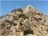 21
21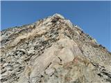 22
22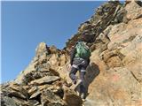 23
23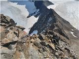 24
24 25
25 26
26 27
27 28
28 29
29 30
30 31
31 32
32 33
33 34
34 35
35 36
36 37
37 38
38 39
39 40
40 41
41 42
42 43
43 44
44 45
45 46
46 47
47 48
48 49
49 50
50 51
51 52
52 53
53 54
54 55
55 56
56