Bela Peč / Villa Bassa - Črni vrh / Colrotondo
Starting point: Bela Peč / Villa Bassa (770 m)
| Latitude/Longitude: | 46,49260°N 13,63960°E |
| |
Walking time: 2 h
Difficulty: easy unmarked way
Elevation gain: 716 m
Elevation difference along the route: 716 m
Map: Julijske Alpe - zahodni del 1:50.000
Recommended equipment (summer):
Recommended equipment (winter): ice axe, crampons
Views: 758
 | 1 person like this post |
Access to starting point:
A) First, we drive to Kranjska Gora, and then we continue driving towards Rateče and further into Italy. Further on, we drive towards Trbiž / Tarvisio, a little after the turn-off of the road towards the Belopeška lakes / Lago di Fusine, and the road branches off to the left towards the settlement Ahlete / Aclete. We continue on the mentioned road, which leads us past a few more houses, and then we go slightly right from the asphalt road, so that we drive through the underpass of the former railway track, today a cycling path. On the other side of the underpass, we park at an appropriate place.
B) Over the border crossing Predel, we drive to Italy, and then we continue driving towards Trbiž / Tarvisio and further towards Rateče. In the settlement Bela Peč / Villa Bassa, the road branches off to the right towards the settlement Ahlete / Aclete. We continue on the mentioned road, which leads us past a few more houses, and then we go slightly right from the asphalt road, so that we drive through the underpass of the former railway track, today a cycling path. On the other side of the underpass, we park at an appropriate place.
Route description:
From the starting point, we continue on a macadam road which leads us over a bridge, and then continues along the Črni potok / Rio Nero stream. A little further, the blazes end, because the marked path towards Koprivnik / Ortigara and Valromana turns right from the road into the forest. The initially gentle road soon starts to ascend visibly and brings us to a dam, and a little further it also leads us past the statue of St. Mary. Higher up, we cross the stream a few times, and then behind the hut the road turns into a quite steep cart track. At the crossings, we follow the cart track along the "main" path; at an altitude a little less than 1300 m, the marked path from Koprivnik joins from the right. We ascend along the blazes for approximately 15 minutes, and then before the saddle Črni vrh / Sella di Colrotondo, the marked path turns right and ascends to the mentioned saddle, where there is a marked junction.
We do not ascend to the saddle a few steps away and continue left on the unmarked cart track, to which the path from the Belopeška lakes / Lago di Fusine joins from the right a minute higher up.
We continue on the cart track, which ascends gently to moderately and leads towards the north. Higher up, we reach the highest point of Črni vrh, but we continue for approximately another minute to a larger clearing, where there is a hunting observatory and from which a beautiful view opens up.
Starting point - Jezerska planina 0:15, Jezerska planina - saddle Črni vrh 1:00, saddle Črni vrh - Črni vrh 0:25.
Description and pictures refer to the condition in the year 2018 (November).

Photos:
 1
1 2
2 3
3 4
4 5
5 6
6 7
7 8
8 9
9 10
10 11
11 12
12 13
13 14
14 15
15 16
16 17
17 18
18 19
19 20
20 21
21 22
22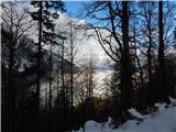 23
23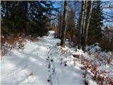 24
24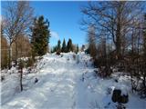 25
25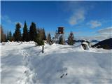 26
26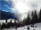 27
27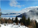 28
28 29
29
Discussion about the trip Bela Peč / Villa Bassa - Črni vrh / Colrotondo
To post a comment you must log in:
If you do not yet have a username, you must first
register.