Starting point: Bele Vode (980 m)
| Latitude/Longitude: | 46,40840°N 13,53400°E |
| |
Walking time: 3 h 30 min
Difficulty: partly demanding marked way
Elevation gain: 1146 m
Elevation difference along the route: 1150 m
Map: Julijske Alpe - Zahodni del 1:50000
Recommended equipment (summer):
Recommended equipment (winter):
Views: 162.775
 | 7 people like this post |
Access to starting point:
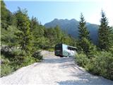
A) From Kranjska Gora over the border crossing Rateče we drive to Trbiž / Tarvisio. In Trbiž we continue left in the direction of Bovec and we follow the road to the crossroads near the lake Rabeljsko jezero. Here we continue right in the direction of Nevejski preval (V Žlebeh) / Sella Nevea. This road, which is mostly ascending, we follow to the bridge, where at the left turn the road crosses the stream Bele vode / Rio Bianco. On the left side of the road, we will notice a few smaller parking spots. There are many more of them left lower on the gravel terrain, to which a short turn-off leads.
B) From Bovec, we drive to the border crossing Predel, from which we descend on the Italian side. Only a little after the lake Rabeljsko jezero we come to a crossroads, where we continue left in the direction of Nevejski preval (V Žlebeh) / Sella Nevea. Further, we follow the description above.
Route description:
From the parking lot by the edge of the gravel terrain we take the marked path 653 for Jerebica / Cima del Lago; we go on the gravel road, we twice cross the area where after snow melting flows meltwater into the lake Rabeljsko jezero. Before we come to the edge of the forest we see a signpost which directs us right, after some 10 m we go right again, after the next 10 m to the left upper cart track. This soon flattens and changes into a flat footpath in the forest, only a few meters above the gravel terrain. When the footpath brings us to a cart track we continue left, higher at the next junction where path 654 branches off to the right, then left again. We continue for some time on a gentle cart track, after which a cairn and trail blaze lead us to a forest footpath which we partly follow in zigzags for half an hour. Higher we come out of the forest, we several times cross areas which are a little more overgrown with bushes. Higher we ascend right above the bottom of the valley, above which the path turns left and ascends partly over scree which takes us to Jezersko sedlo. Here the path joins with the one from Možnica and there continues left (signpost Cima del Lago 1.5h). We continue on the footpath which slowly ascends, a little further it turns sharply right below Gorenji Vogel and then once again sharply left, after which the path leads briefly on a wide ledge, higher we slowly ascend to an indistinct saddle between Gorenji Vogel and Gorenji Krivi rob. We ascend a little more steeply, then the path turns left where just below the summit of Gorenji Krivi rob it flattens, after which a descent follows (here for the first time we see the summit proper of Jerebica). First gently, then also over a 5-meter rocky step which must be climbed, but the holds are good, so there are no difficulties. Soon we come to the saddle between Gorenji Krivi rob and Jerebica, then follows a traversing gentle ascent toward the summit, in between due to the demanding terrain we have to grab rocks twice. Higher we come to the summit saddle, a few steps higher we see the lake Rabeljsko jezero on the left and soon we find ourselves on the summit of Jerebica.

Along the route: Jezersko sedlo (1720m)
Photos:
 1
1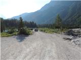 2
2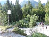 3
3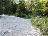 4
4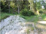 5
5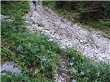 6
6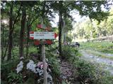 7
7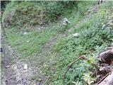 8
8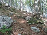 9
9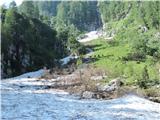 10
10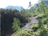 11
11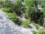 12
12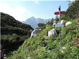 13
13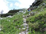 14
14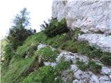 15
15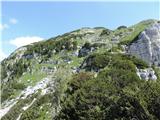 16
16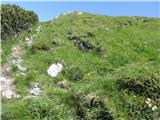 17
17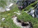 18
18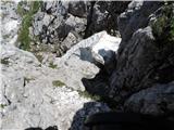 19
19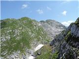 20
20 21
21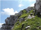 22
22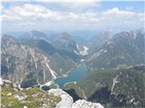 23
23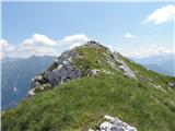 24
24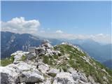 25
25
Discussion about the trip Bele Vode - Jerebica
|
| mojcika9. 08. 2014 |
Yesterday my husband and I conquered the summit of Jerebica from Bele Vode. The path is well traceable, although the Italian markings are different from ours, they helped us a lot. Because there is a lot of moisture, the path was slippery, but the surroundings full of flowers - from foxgloves, edelweiss, to rhododendrons, primroses... Caution was not superfluous, but there was no snow on the path.
The views were wonderful. At the top we met a very friendly young mountaineer Jani, who respected experiences, while we learned a lot about the western Alps, and other information was pleasant and interesting. As we found out later, he is also a very good photographer.
|
|
|
|
| meta5011. 08. 2014 |
Congratulations mojcika.... nice tour. Despite many hiked paths, something new can always be found.... 
|
|
|
|
| Janiel7411. 08. 2014 |
@mojcika: Nice viewpoint yes, but to the Western Julian Alps definitely!
|
|
|
|
| nanica1. 10. 2014 |
Last Saturday on Jerebica. The trail below in the forest is a bit harder to follow,
as it is already quite covered by fallen leaves. Then the path is very slippery due to moisture, soaked soil and smooth rocks. From the saddle onwards the path is without special features. At the summit very warm, no wind, the views were clear and extended far around. No crowds, so we enjoyed the summit for a full two hours, as we couldn't get enough of the views of the surrounding mountains.
On the way back towards Vršič we made a few short stops in the Posočje I love so much, which made the day perfect.
|
|
|
|
| Grenaleva18. 08. 2016 |
The path from the Italian side is very nicely marked. The starting point is a few km after the end of the lake, in August they were laying new asphalt and at the end of the asphalt there is a large stone bridge to the left, before the bridge there is parking and sign Cime del Lago 4 hours. Then the path follows nicely all the way to Jezersko sedlo, from where further to Slovenian markings. Mountain with magnificent views, highly recommend visiting it
|
|
|
|
| lepenatka9. 07. 2017 |
Yesterday on Jerebica. Good thing this path is mostly through the forest for a while.
Strawberries took care of the vitamin breakfast.
At the saddle where the path from Možnica joins, new markings are visible. Hikers also said that the path is newly marked and easy to follow.
"Aladin" predicted a shower and it really was then.
|
|
|
|
| Planinka7416. 06. 2018 |
I wonder if the path from Bele Vode is completely dry? Thanks
|
|
|
|
| ping8520. 09. 2018 |
The path is easily followable throughout (well marked), and quite steep. After coming out of the forest to the junction where the Slovenian path joins, it's very slippery due to the shady position. On the exposed sections, some handholds or a meter of cable wouldn't hurt (especially because Jerebica has gained fame for its nice view through social media and thus attracts many hikers who think it's a few-minute stroll). In short, the path requires some fitness and caution, but every effort is rewarded with a nice view.
I also add criticism because there is no stamp at the top.
|
|
|
|
| ločanka20. 09. 2018 |
Were you up there yesterday?
|
|
|
|
| jessa6. 06. 2020 |
Cima del lago or Jerebica, the 2126 m high peak delights with views of Rabeljsko jezero lake, Robon, Montaž and other mighty alpine peaks. Due to snowdrifts that make the path difficult after the saddle, the ascent takes up to half an hour longer. The trail slips in some places and literally separates from the rock, but with caution, everything is manageable, and the views are beautiful. The summit is not exposed, there is no crowd, but there is no stamp either, only a logbook. Still, it is worth going.
|
|
|
|
| Jani33310. 06. 2020 |
Jessa
Are crampons needed due to the snowfield after the saddle? Or no panic? Is the terrain dangerous there at the end of the snowfield?
thanks
|
|
|
|
| epvlonhistria26. 07. 2020 |
Jessa
Nice description. Small remark, completely personal. I think
namely that it would be nice not to list Italian mountain names, which arose from Italianization
of original exclusively Slovenian toponyms.
Isn't the Slovenian name Jerebica beautiful enough? In this way we don't want to forget historical injustices towards our neighboring and close Slovenian people
|
|
|
|
| J.P.27. 09. 2021 20:09:01 |
The path is nicely followable, a bit boring to the saddle. From the saddle onwards it's pure beauty. From the top we have a 360 view of pure gems. I recommend to all.
|
|
|
|
| ejas123411. 07. 2022 15:57:06 |
Hello
I plan to go to Jerebica these days
How is the path, are there any peculiarities?
Is anything exposed?
Thanks
|
|
|
|
| darinka411. 07. 2022 17:30:22 |
A week ago. But from Možnice. Mainly hikers from Bele Vode. The path from Jezersko sedlo to the summit is nicely traceable. Need to be careful with snakes. Last time a black adder was sunning itself on the path. Further from the saddle on the Italian side. So you don't step on it. Further on, when you descend a bit, you need to be a little careful on part of the path. Otherwise a nice path all the way to the top.
|
|
|
|
| ejas123411. 07. 2022 20:28:42 |
Thanks for the information.
|
|
|
|
| ejas123413. 07. 2022 09:34:32 |
I was there yesterday.
The path is really beautiful and varied.
You need a good pace.
The upper part of the path is full of beautiful views.
It took me 4 hours up and 3 hours down.
Really nice experience.
|
|
|
|
| darinka413. 06. 2023 20:43:17 |
Even though there was no sun and no views. No rain either, the hike was really nice. In solitude. Admiring the rhododendron, which is now blooming in all its beauty.
|
|
|
|
| Ojstrica3315. 06. 2023 12:47:31 |
darinka4, how is the trail? Is there still any snow? Thanks for the info
|
|
|
|
| darinka415. 06. 2023 13:37:54 |
There are two snowfields. I posted pictures with the report, a bit earlier if you look. Only the one where the path descends is a bit awkward, but you can cross it. We had an ice axe with us in case it was needed, but didn't use it. Snow is melting every day. Regards. Regarding the path. It was quite slippery and wet from dew. But doable carefully. I thought the path from Rablja is less steep. Jezersko sedlo is quite far. Especially in the last part where you walk on scree for a while.
|
|
|
|
| ljubitelj gora19. 06. 2023 14:02:10 |
Now it's possible to park only by the road, you can't go down with a car, they've installed a barrier, not just one, and also around Rabeljsko jezero they've added fences and barriers.
|
|
|
|
| rensul9. 07. 2023 22:12:29 |
Yesterday the barrier was up, parking meter installed (8€/day) but not working. Payment only with coins and cards. Since it didn't work, we wrote notes about the non-working parking meter and left them on the dashboard.
|
|
|
|
| Robie8. 10. 2023 18:50:05 |
Parking meter removed, barrier locked with a padlock. No longer possible to park anywhere but squeeze the car to the side of the road  or in those few "unofficial" parking spots along the road, which fill up quickly on weekends. or in those few "unofficial" parking spots along the road, which fill up quickly on weekends.
|
|
|
|
| VanSims9. 10. 2023 18:08:20 |
What @darinka4 already warned about, I felt too. Really careful, almost the entire trail from the forest edge to the saddle between Gorenji Krivi Rob and Jerebica is in a shady position. When there's morning dew, it lingers until the afternoon, so extreme caution is needed, especially on descent, mainly at exposed spots in the upper part after the junction with the trail from Možnica.
|
|
|
|
| natasacraine14. 07. 2024 20:18:33 |
Is the parking lot still closed? 
|
|
|
|
| mirank14. 07. 2024 20:42:14 |
When we drove past, cars were everywhere along the road and also down at the parking lot, but there's a new sign prohibiting traffic to the Viš starting point. Consequently, there was a crowd there along the road and at that cross on the junction.
|
|
|
|
| smatjaz2. 09. 2024 17:03:16 |
....pay those 8 euros and you have peace, last time they were handing out hefty fines to those on the roadside. At the parking lot below, you need to be careful not to leave "interesting" things visible in the car, because they break into cars.
|
|
|
|
| ljubitelj gora15. 10. 2024 14:08:35 |
If I saw correctly, there is no parking meter there now. If there is, you can still park a bit further.
|
|
|
|
| bo_zl16. 10. 2024 19:14:48 |
You can park for free at the beginning of the road in Možnica, and nicely along the path on the Slovenian side to the top.
|
|
|
|
| mirank19. 10. 2024 21:26:50 |
It seems it's free here too, as the parking meter wasn't working last time, and the barrier was raised?
|
|
|
|
| KKatjusa11. 11. 2025 12:20:26 |
Hello! Does anyone have verified info on the current snow conditions on Jerebica? Trail start at Rabeljsko jezero.
Thanks
|
|
|
To post a comment you must log in:
If you do not yet have a username, you must first
register.