Bilopolje - Sveti Ilija (Pelješac)
Starting point: Bilopolje (150 m)
| Latitude/Longitude: | 42,97740°N 17,15390°E |
| |
Walking time: 2 h 20 min
Difficulty: easy marked way
Elevation gain: 811 m
Elevation difference along the route: 811 m
Map:
Recommended equipment (summer):
Recommended equipment (winter):
Views: 10.750
 | 1 person like this post |
Access to starting point:
We drive through Orebić, at the sign for Viganj and Lovište, we turn right. Soon after that we again turn sharply right, at the sign for the Franjevački samostan Gospe od Anđela monastery. An asphalt road brings us to the monastery, where in the parking lot we leave the car.
Route description:
From the monastery, where we've parked, we continue on the road towards the settlement Bilopolje (approx. 800 m), and there a sign for Sv. Ilija 2 hours 20 min directs us right. The path continues past the house, where we turn left (we follow the blazes). The path ahead runs through bushes and is well marked with blazes.
During the ascent, we have a view of the island Korčula for a longer time.
We soon come to a fork in the pine forest, for paths in the direction of Nakovana, Viganj, Sv. Ilija, and we continue right towards the signs for Sv. Ilija. From the pine forest we reach the mountain hut, which was renovated in 2008.
From the mountain hut, we continue left, uphill (look for the signs), and the path runs along the ridge and after a good 25 minutes we come to the top. The peak is marked with a wooden cross. On the rock there is an embedded plate, on which the name of the peak and the altitude are written. In addition, a metal mountain stamp and a book with a register of visitors are embedded.
P.S. On this summit there are many warnings that it is full of snakes, and not without reason; it is called snake mountain. It is recommended that on this path we go properly shod and dressed. With sufficient water, because there is no drinking water along the path.

Photos:
 1
1 2
2 3
3 4
4 5
5 6
6 7
7 8
8 9
9 10
10 11
11 12
12 13
13 14
14 15
15 16
16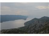 17
17
Discussion about the trip Bilopolje - Sveti Ilija (Pelješac)
|
| Peter Pehani14. 08. 2017 |
To St. Ilija there is also fully pedestrian access without a car. If located in Perni (camp Perna or Palma), the marked path branches off the main coastal road right at the eastern end of Kućište (at the start of the tourist settlement Perna; about 800 m from camp Perna towards Orebić), reaching Bilopolje after 20-30 steep minutes.
More ingenuity is needed for the path starting right above camp Perna (between reception and shop steeply up into the forest), as branches are unmarked. This path first goes to St. Anne's chapel (visible from below, 20 min), then some orienteering ingenuity to find the junction to the marked path (from St. Anne first west along path, then east along cart track, then west again past St. Lawrence chapel and villa ruins, then up to marked path). For more info write!
If in camps in Viganj (Antony Boy, Maestral, ...), the footpath branch is in the far western part of Kućište (by Holy Trinity church; about 300 m from Antony Boy towards Orebić).
And two interesting details. All signs for the branch to St. Ilija (also in Bilopolje) face east, so coming from west, branches are poorly visible. Times given to the exact 5 minutes, even finding 0.55 h.
|
|
|
|
| skiro1233. 07. 2020 |
Visited the summit end of June 2020. No need to park at the monastery, as there are some parking spots near the starting point (800m closer). No snakes in sight, just a little marten. Due to potentially high heat, it's important to start up to 2 hours after official sunrise, better even earlier. Walking through the pine forest takes 30 minutes (both ways), which nicely facilitates access.
|
|
|
|
| Peter Pehani17. 08. 2022 16:19:58 |
Status August 2022: The road from the monastery to Bilopolje is newly asphalted. At the place where the path leaves the asphalt, someone (as if on purpose?) removed the Sv. Ilija sign from the pole (which is in picture 1; but the signs for Kućište and Orebić are still on the pole, so no dilemma where to turn right from the road or northwards). Parking is also possible 200 m further from this sign, at the Panorama tavern (which operates only in the afternoon/evening).
|
|
|
To post a comment you must log in:
If you do not yet have a username, you must first
register.