Bistrica v Rožu / Feistritz im Rosental - Rabenberg
Starting point: Bistrica v Rožu / Feistritz im Rosental (549 m)
| Latitude/Longitude: | 46,52240°N 14,17650°E |
| |
Walking time: 3 h 20 min
Difficulty: easy unmarked way
Elevation gain: 916 m
Elevation difference along the route: 925 m
Map: Karavanke - osrednji del 1:50.000
Recommended equipment (summer):
Recommended equipment (winter): ice axe, crampons
Views: 316
 | 1 person like this post |
Access to starting point:
A) Through the Karawanks Tunnel, we drive into Austria, then continue on the motorway towards Beljak, which we leave at the first exit. From the place where we left the motorway, we follow the signs for the settlement Šentjakob v Rožu / Sankt Jakob im Rosental. When we arrive in the mentioned settlement, we continue on the main road past Podgorje / Maria Elend and the settlement Sveče / Suetschach to the settlement Bistrica v Rožu / Feistritz im Rosental, where behind the Billa and Penny stores we turn right towards the settlement Sine / Sinach. Since there are no arranged parking spots for hikers at the intersection, we drive a little further and park at a suitable place by the road.
B) Through the Ljubelj border crossing, we drive into Austria, where on the main road towards Celovec / Klagenfurt am Wörtersee we drive to the second roundabout, from which we continue driving towards the Bistrica v Rožu / Feistritz im Rosental exit (we leave the main road towards Celovec before crossing the Drava River). In Bistrica v Rožu, at the Peugeot car dealership, we turn left onto the side road towards the dentist (on the sign Zahnarzt, signs for the village Sine / Sinach are only from the opposite direction). Since there are no arranged parking spots for hikers at the intersection, we drive a little further and park at a suitable place by the road.
C) From Dravograd or Slovenj Gradec we drive to Ravne na Koroškem, then continue driving towards the Holmec border crossing. When we enter Austria, we first drive towards Pliberk / Bleiburg, then follow the signs for Globasnica / Globasnitz and further to Železna Kapla / Bad Eisenkappel, Borovlje / Ferlach. After Borovlje, at the roundabout we join the road via the Ljubelj border crossing. Here, at the first roundabout we continue towards Celovec / Klagenfurt, at the second towards Bistrica v Rožu / Feistritz im Rosental. In Bistrica v Rožu, at the Peugeot car dealership, we turn left onto the side road towards the dentist (on the sign Zahnarzt, signs for the village Sine / Sinach are only from the opposite direction). Since there are no arranged parking spots for hikers at the intersection, we drive a little further and park at a suitable place by the road.
Route description:
From Bistrica v Rožu / Feistritz im Rosental we continue on the asphalt road, along which we ascend towards the village Sine / Sinach. During the ascent along the road, a nice view temporarily opens up on the Bistrica reservoir / Feistritzer Stausee, a little further we arrive at Olipcov križ, where the path splits for the first time.
We continue straight ahead (also left is possible, as the paths quickly merge) and along the gently sloping asphalt road quickly arrive at the next marked junction, from which we go left (right is the western path to Psinski vrh / Sinacher Gupf) in the direction of Psinski vrh and saddle Vranjica / Oreinzsattel. The previously mentioned path, which branched off at Olipcov križ, quickly joins the asphalt road from the left, and we continue past a few houses. At the last house, where the path from the settlement Šentjanž v Rožu / St. Johann im Rosental joins from the left, the asphalt ends, and we continue right onto the macadam road in the direction of Psinski vrh via saddle Vranjica. For some time we walk along the macadam road, which at the junctions we follow in the direction of the markers, a little further we go slightly right from the road onto the marked path, which in the forest due to timber extraction disappears. When the forest ends we continue along the clearing (the trail is also difficult to follow on this section), when we reach the cart track we continue right to the forest entrance, where the markers reappear. In continuation we walk along a rarely visited path, which initially runs along a cart track through the forest, later temporarily runs across a shorter swampy section. The overgrown path then returns to the forest and temporarily ascends more steeply. The path full of obstacles, mainly branches and fallen trees, then transitions to a steep slope, where we traverse towards the left, followed by crossing a torrent stream. On the other side of the stream the trail can still be followed for a short time, then we arrive at a larger clearing, where we first clamber over a few fallen trees, behind the fallen trees the trail almost completely disappears. Across the clearing we continue traversing towards the left, when we reach the place where the slope steeply drops towards the second torrent, we continue right upwards. Here the trail reappears, and we also spot a few markers. When the path returns to the forest, we step onto a cart track, along which we continue the ascent. The cart track quickly flattens, at the nearby marked junction it turns into a forest road.
We continue right in the direction of Psinski vrh (left Šentjanž v Rožu) and continue along a small valley, where we quickly arrive at the first junction at saddle Vranjica.
Here we go left in the direction of Žingarica / Singerberg (if we continue straight and at the second junction at saddle Vranjica go, we can ascend to Psinski vrh) and begin to ascend traversing along the macadam road. A traversing ascent towards the left follows, where we ascend along the slopes of peak Rabenberg, at the junctions following the wider or marked road. Higher up, in the area called Velika ravna the road temporarily flattens, then ascends traversing to saddle Albink, where there is a marked junction.
From the junction at saddle Albnik we continue sharply right onto the unmarked road (left Žingarica, straight Slovenji Plajberk), along which we moderately ascend for some time, then the road, from which occasional views mainly towards the north open up, flattens. In the last section we follow the gentle road to its end from where we continue left and in a few steps ascend to the highest point of peak Rabenberg.
Bistrica v Rožu - Sine 15 minutes, Sine - saddle Vranjica 1:50, saddle Vranjica - saddle Albink 0:50, saddle Albink - Rabenberg 0:25.
The description refers to the condition in June 2018 and December 2019.

Along the route: Sine / Sinach (619m), Sedlo Vranjica / Oreinzsattel (1122m), Albink / Halbingsattel (1360m)
Photos:
 1
1 2
2 3
3 4
4 5
5 6
6 7
7 8
8 9
9 10
10 11
11 12
12 13
13 14
14 15
15 16
16 17
17 18
18 19
19 20
20 21
21 22
22 23
23 24
24 25
25 26
26 27
27 28
28 29
29 30
30 31
31 32
32 33
33 34
34 35
35 36
36 37
37 38
38 39
39 40
40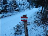 41
41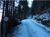 42
42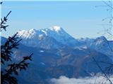 43
43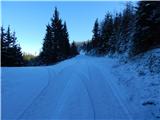 44
44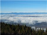 45
45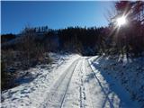 46
46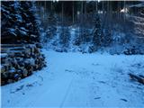 47
47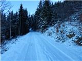 48
48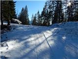 49
49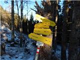 50
50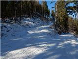 51
51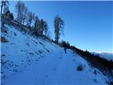 52
52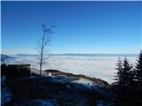 53
53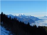 54
54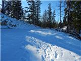 55
55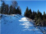 56
56 57
57 58
58 59
59 60
60 61
61
Discussion about the trip Bistrica v Rožu / Feistritz im Rosental - Rabenberg
To post a comment you must log in:
If you do not yet have a username, you must first
register.