Bistriška planina - Dobrča
Starting point: Bistriška planina (1057 m)
| Latitude/Longitude: | 46,37970°N 14,27410°E |
| |
Walking time: 1 h 30 min
Difficulty: easy marked way
Elevation gain: 577 m
Elevation difference along the route: 577 m
Map: Karavanke - osrednji del 1:50.000
Recommended equipment (summer):
Recommended equipment (winter):
Views: 127.689
 | 3 people like this post |
Access to starting point:
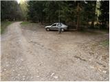
From the Ljubljana - Jesenice highway, take the Ljubelj exit and follow the road ahead in the direction of Tržič. Just before the gas station near Tržič, turn right (direction Tržič) and then immediately left (direction Begunje) and drive further to the village Brezje pri Tržiču. In the village Brezje pri Tržiču, at the top of the climb, turn right towards Bistriška planina. After approximately 100 meters, reach an intersection, where turn right onto the forest road. The road, which ascends quite steeply further on, brings us after some time to Bistriška planina, where we park on the parking lot by the road (Brezje pri Tržiču - Bistriška planina 3.1 km, of which 2.6 km macadam).
Route description:
From the parking lot at Bistriška planina we continue on a macadam road which after a short ascent brings us to Breška planina, which we recognize by a wooden cottage. The worsening road then brings us to a junction, where we continue right on a steep cart track in the direction of Lešanska planina. The cart track up which we then ascend has some junctions, but if we follow the blazes it brings us to the mentioned mountain pasture without any bigger problems, from which a nice view opens up on Storžič and Tolsti vrh.
On the mountain pasture, where there also stands a shepherd hut of open type, we have two options to continue. We choose the right one, which is a little shorter and more panoramic. The path, which is somewhat poorly marked, at first takes us to the eastern part of the mountain pasture, where it makes a left turn and then after a further few minutes joins the normal path to Dobrča. Here we continue sharply right and follow the forest path to the top of Dobrča.

Photos:
 1
1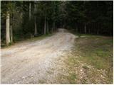 2
2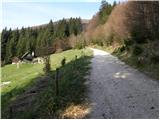 3
3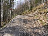 4
4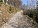 5
5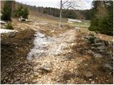 6
6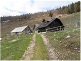 7
7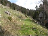 8
8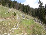 9
9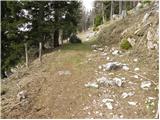 10
10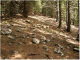 11
11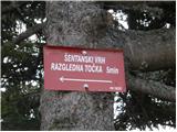 12
12 13
13
Discussion about the trip Bistriška planina - Dobrča
|
| andrej jerina14. 03. 2008 |
Today, due to lack of time, I went along the above-described path. The path is very nice, I think it's also suitable for families. The snow track is made from a few hundred meters above Bistriška planina all the way to the top of Dobrča. Since I went early in the morning, I somewhat missed microspikes, which I recommend also for descent, as the track before the summit is quite frozen. Snow sets quickly. I also recommend visiting Šentanski vrh, which is just a few minutes walk from the top of Dobrča. The track is made. From there is a fantastic panorama towards Stol, Begunjščica, Košuta, Triglav, Storžič,... Best, Andrej
|
|
|
|
| Kriška23. 11. 2008 |
In the hut on Dobrča they changed the tenant (caretaker?), the new team works 3 weeks, as they told me today. The change is very obvious, space tidy, service friendly and fast, food selection appropriate, dumplings really tasty, the rest I'll check on next visits . As far as I noticed, the new crew is all male. I hope to take such a good impression from Dobrča also on next visits. The beginning is really promising! . As far as I noticed, the new crew is all male. I hope to take such a good impression from Dobrča also on next visits. The beginning is really promising!
|
|
|
|
| Fazo21. 06. 2009 |
We were up there today, great weather, great views, a bit windy, žganci and sour milk more than excellent  ...oh yes the caretakers in the hut (gentleman and lady) were super friendly!!! ...oh yes the caretakers in the hut (gentleman and lady) were super friendly!!!
Best, matevž
|
|
|
|
| caplja23. 06. 2009 |
We also set off for Dobrča. I won't waste words on the views. It's a balcony. About the staff in the hut, I can say they are among the best in mountain huts.
|
|
|
|
| jera30. 08. 2009 |
This year we too went back to Dobrča after five years. We were surprised by the friendliness of the caretaker and the female caretaker. We fortified ourselves with stew (vampi), very, very excellent. Overall all praise to both!
|
|
|
|
| kris27. 03. 2010 |
has anyone been to Dobrča recently, I'm interested how much snow there is
|
|
|
|
| šoja16. 04. 2010 |
No more snow at the hut, but there's still a little on the top, though it will probably melt now too.
|
|
|
|
| caplja31. 12. 2010 |
Yesterday, 30.12.2010, we headed to Dobrča.
The day was sunny so we convinced a friend of the mountains and went from the hut to Šentanski vrh as well. The view was wonderful. Upon arrival at the hut, the friendly staff provided us with drinks and huge portions of very tasty food.
Thanks again to them and all the best and
HAPPY NEW YEAR 2011
|
|
|
|
| wolphgang1. 04. 2011 |
hello, I'm interested in what condition the road to Bistriška planina is in.
|
|
|
|
| bobo11. 04. 2011 |
the road is normally drivable. except maybe some bigger pothole on the asphalt section. otherwise yesterday great weather and equally great views. food in the hut excellent.
|
|
|
|
| Lunca8. 05. 2011 |
Yes, the hardest part is on the section where there's still asphalt, then it goes normally onwards. At the top of Dobrča about a week ago there was no stamp, the logbook was also full... I also recommend a visit to nearby Šentanski vrh - wonderful view!
|
|
|
|
| Lucy25. 08. 2011 |
I also visited the hut on Dobrča, but some time ago. That day there was quite a crowd, so we had to wait a bit longer for service. I can tell you that the food is excellent, and the hut staff friendly and obliging. The path itself is easy and straightforward, I'll surely visit again sometime.
|
|
|
|
| vrho9. 01. 2012 |
yesterday we headed to the top of Dobrča, the trail is ok but somewhat icy in places, especially from the hut on Dobrča to the top of Dobrča it's icy and snowy - about 15cm of snow
|
|
|
|
| ciklama21. 01. 2012 |
Today we went past Bistriška and Lešanska planina to Dobrča. On larger sections the road is very icy - I recommend crampons. We descended to the hut and were surprised by the friendliness of the staff and the varied menu, which could be an example for many of our huts. We descended to the valley along the ridge path. Here too (especially higher up) there are icy sections, so I fell properly once, despite crampons. Caution is needed on every tour these days! 
|
|
|
|
| kaanja17. 11. 2012 |
Today at Šentanski vrh on the stamp box I forgot my notebook (light brown color, hardcover), where I record conquered summits. If someone found it and took it to the valley, please contact me. Many thanks!
|
|
|
|
| CarpeDiem24710. 07. 2013 |
Since everyone mentions the incredible friendliness of the staff at the hut on Dobrča, I set out towards this peak today too. It was great, of course I also went to Šentanski vrh.
The road in the asphalt section isn't that bad (slightly larger potholes only in the part where the "drainage track" for water runoff from the roadway is laid), later on the gravel road it's somewhat different, as there are (I remember for the uphill, 2 left steep turns), where drivers shift from 2nd to 1st gear and consequently dig in with the wheels. In this section, the road most resembles a motocross or BMX track. 
I have a relatively low-clearance vehicle - Mazda 6, so with a somewhat higher one you could get quite close to Lešanska planina, e.g., to the above-mentioned junction where the path steeply climbs and goes right up (sign Lešanska planina). That's all for today, good luck.
|
|
|
|
| zabava12. 09. 2016 |
We girls also headed to Dobrča. It was a beautiful day, really friendly at the hut, food excellent. It's praiseworthy that so many young people are hiking in the mountains, nice to see them. Safe steps to you
|
|
|
|
| Anja Banja18. 08. 2017 |
At the bend where the sign for Dobrča is, there are also signs for parking. But this parking is not the starting point, so as not to mislead anyone... from the starting points there is then a long and boring road (asphalt at the beginning), which is definitely better to drive by car.
|
|
|
|
| michael6610. 03. 2022 19:37:46 |
And who knows, what's the condition of the macadam to Bistriška planina?
|
|
|
|
| michael666. 04. 2024 21:00:13 |
What is the current condition of the macadam to the mountain pasture?
|
|
|
|
| anica.zu8. 04. 2024 12:19:34 |
Very nice macadam. I was there on Saturday.
|
|
|
|
| anica.zu8. 04. 2024 12:21:08 |
Don't forget to go from the top of Dobrča to Šentanski vrh as well (5 min.). The views on Saturday were divine.
|
|
|
|
| michael668. 04. 2024 13:06:53 |
We went yesterday straight from Brezje. Of course also to Šentanski vrh. Thanks for the info anyway.
|
|
|
|
| natasacraine13. 08. 2024 19:43:05 |
And does anyone know if the road is ok? Macadam...
|
|
|
|
| michael6625. 06. 2025 18:04:08 |
How is this road/macadam this year? Has anyone driven it recently?
|
|
|
To post a comment you must log in:
If you do not yet have a username, you must first
register.