Bohinjsko sedlo - Slatnik (northwestern peak) (direct way)
Starting point: Bohinjsko sedlo (1277 m)
| Latitude/Longitude: | 46,24090°N 14,01000°E |
| |
Route name: direct way
Walking time: 1 h
Difficulty: easy unmarked way
Elevation gain: 332 m
Elevation difference along the route: 332 m
Map: Škofjeloško in Cerkljansko hribovje 1:50.000
Recommended equipment (summer):
Recommended equipment (winter): ice axe, crampons
Views: 9.551
 | 4 people like this post |
Access to starting point:
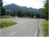
From the highway Ljubljana - Jesenice, take the Lesce exit and follow the road towards Bled and then towards Bohinjska Bistrica. From Bohinjska Bistrica, continue left in the direction of Tolmin and Soriška planina. Follow this road to a large parking lot near the ski center Soriška planina.
From Železniki, drive towards Podbrdo or vice versa, but only to the spot where signs for Soriška planina direct us onto an ascending road. Follow this road to a large parking lot at the foot of the ski slope Soriška planina.
Route description:
From the parking lot on Bohinjsko sedlo, head onto the macadam road in the direction of the mountain hut Litostrojska koča on Soriška planina. After less than 5 minutes of gentle ascent, arrive at the mentioned mountain hut, from which a view opens up onto the nearby grassy slopes of the surrounding peaks.
From the hut, continue on the marked path in the direction of Šavnik, Možic and Lajnar. After a few dozen steps, reach a less noticeable junction, where the path to Možic branches off slightly to the right (sign on the tree, straight to Lajnar). Take the mentioned path, which continues gently ascending along the edge of the grassy slopes of Soriška planina. Slightly higher up, the marked path turns right and begins to ascend more steeply through a belt of sparse forest and shrubbery. The path soon leaves the forest and leads us into a small valley, along the edge of which we then climb to an old military barracks (barracks converted into a sheep stable, next to which there is a small shepherd's hut).
From the barracks, passing a small chapel, climb to an indistinct ridge, where the path from Lajnar joins from the left. Continue left (straight to Šavnik and Možic) along the panoramic grassy ridge, along which in less than 5 minutes of further walking we ascend to the summit of Slatnik.

Photos:
 1
1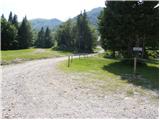 2
2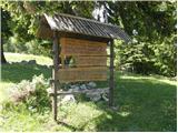 3
3 4
4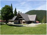 5
5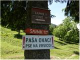 6
6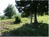 7
7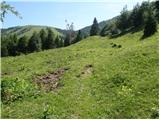 8
8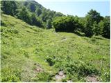 9
9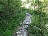 10
10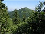 11
11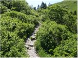 12
12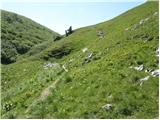 13
13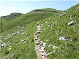 14
14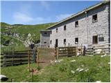 15
15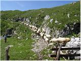 16
16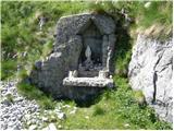 17
17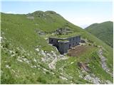 18
18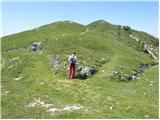 19
19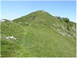 20
20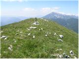 21
21
Discussion about the trip Bohinjsko sedlo - Slatnik (northwestern peak) (direct way)
|
| Majdag3. 02. 2023 07:38:48 |
With snowshoes to Baško sedlo and Slatnik on the 1st holiday day. The road to Soriška planina is clear and wonderful to drive. On both sides there are high snowdrifts. There is enough snow on the pasture, walkers and snowshoers have their own path. The views from the saddle are wonderful, there are beaten tracks in all directions, even to Možic. A real winter idyll on the pasture..
https://jelenkamenmajdag.blogspot.com/2023/02/potepanje-s-krpljami.html
|
|
|
|
| ropontika6. 02. 2023 07:30:40 |
It's a pleasure to read your path descriptions and I hope we'll read you for a long time, congratulations. Since there's the village Bača there, it's probably Bačarsko sedlo up there. Just checking, no offense.
|
|
|
|
| Majdag6. 02. 2023 09:10:23 |
ropontika thanks, I'm glad if you also looked at the pictures, on the arrow in the slope above Kor it's written Baško sedlo. It could also be Bačarsko, I know that..
|
|
|
|
| franca6. 02. 2023 22:25:42 |
The saddle was called Vrh Bače. In recent years the saddle name is becoming established, similarly Pavličevo sedlo instead of Pavličev vrh.
|
|
|
|
| ločanka7. 02. 2023 05:45:41 |
Vrh Bače is another one, 1273 m and elsewhere. At the intersection of the path coming under Slatnik from Petrovo Brdo and the path coming from Podbrdo (saddle between Kobla and Šavnik). That's what maps show and descriptions are everywhere.
|
|
|
To post a comment you must log in:
If you do not yet have a username, you must first
register.