Borovlje / Ferlach - Borovski vrh (Žehtar) / Sechter (Raketensteig)
Starting point: Borovlje / Ferlach (466 m)
| Latitude/Longitude: | 46,52320°N 14,30340°E |
| |
Route name: Raketensteig
Walking time: 2 h 55 min
Difficulty: partly demanding marked way
Elevation gain: 983 m
Elevation difference along the route: 983 m
Map: Karavanke - osrednji del 1:50.000
Recommended equipment (summer):
Recommended equipment (winter): ice axe, crampons
Views: 1.180
 | 1 person like this post |
Access to starting point:
Via the Ljubelj border crossing we drive into Austria, then we drive along the main road towards Celovec / Klagenfurt, but only as far as the settlement Podljubelj / Unterloibl, where we continue right in the direction of the Hofer store and the police. Further down we arrive in Borovlje / Ferlach, where we cross the railway track, a little further on we turn right towards the settlement Bajdiše / Waidisch. Beyond the Eurospar store we turn right and park in the parking lot by the Borovlje / Ferlach railway station.
Route description:
From the parking lot, we return a little back, where on the west side of the Eurospar store we notice yellow mountain signposts for Borovski vrh / Sechter and Grlovec / Ferlacher Horn. At first, we walk on an asphalt road that crosses the railway track, then past a few houses, fields and meadows in a gentle ascent we walk to Šajdnik / Schaidabauer, where there is a guesthouse.
We continue straight, where we go past garages of agricultural machinery. The first garage we bypass on the right, the second on the left side, then the path enters the forest, where the blazes reappear. The path continues through the forest, where we pass a road reflector and a border stone, a little higher the path forks.
We choose path 659 in the direction of Grlovec and continue the ascent through the forest. Next comes the crossing of a macadam road, then the path becomes increasingly steep, and for a few minutes it is very steep. After the steep section the path levels out, then it crosses a poor road. After the road, from the cart track we go left, where we ascend an overgrown clearing, higher we briefly enter the forest, where we cross the road once again. When a little higher we reach the road again, we follow it to the right-hand hairpin, where on the outside of the bend we notice the continuation of the marked path. The path ahead ascends along the edge of the next clearing; when we reach the end of the road we descend along it to the right for a few steps, then go sharply left onto the footpath, which becomes steeper again. Next follows an ascent in longer zigzags, where we cross several times an extensive (in elevation) overgrown clearing, where the path is harder to pass in several places due to overgrowth or fallen trees. Such an ascent, which also offers nice views, lasts a little longer than 1 hour.
When we leave the clearing we also leave the area with extensive raspberry and wild strawberry patches, and the path further on gradually shifts from the northern to the western slopes of Borovski vrh, where we cross steep slopes. Next follows a traversing ascent that offers occasional views to the west; higher up the path reaches the ridge connecting Borovski vrh with Grlovec.
On the ridge, where the abandoned and formerly secured Ho-Tschi-Minh Pfad path joins unnoticeably from the right (the mentioned path is abandoned, the remaining safety gear is damaged, the ladders have fallen apart, and passage along the heavily eroded path is deadly dangerous), we leave the path to Grlovec and continue sharply left along the ridge.
The path along the ridge ascends moderately at first, then steeply higher up. A little below the summit we emerge from the forest, and via a very steep path we quickly ascend to the panoramic summit.
The description and photos refer to the conditions in 2019 (July).

Along the route: Šajdnik / Schaidabauer (537m)
Photos:
 1
1 2
2 3
3 4
4 5
5 6
6 7
7 8
8 9
9 10
10 11
11 12
12 13
13 14
14 15
15 16
16 17
17 18
18 19
19 20
20 21
21 22
22 23
23 24
24 25
25 26
26 27
27 28
28 29
29 30
30 31
31 32
32 33
33 34
34 35
35 36
36 37
37 38
38 39
39 40
40 41
41 42
42 43
43 44
44 45
45 46
46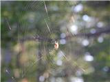 47
47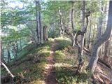 48
48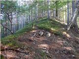 49
49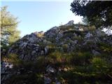 50
50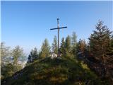 51
51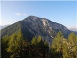 52
52
Discussion about the trip Borovlje / Ferlach - Borovski vrh (Žehtar) / Sechter (Raketensteig)
|
| gcuzak18. 11. 2023 19:59:20 |
Today we went up this path. Due to fallen trees, the path is very difficult to pass. Therefore we decided to go down via a much longer path through Bajdiše. Until the trunks are removed, we advise against the path.
|
|
|
To post a comment you must log in:
If you do not yet have a username, you must first
register.