Breg (Liški potok) - Lisca
Starting point: Breg (Liški potok) (219 m)
| Latitude/Longitude: | 46,05140°N 15,24360°E |
| |
Walking time: 2 h 5 min
Difficulty: easy marked way
Elevation gain: 729 m
Elevation difference along the route: 735 m
Map:
Recommended equipment (summer):
Recommended equipment (winter): ice axe, crampons
Views: 126.627
 | 6 people like this post |
Access to starting point:
From the direction of Zasavje we drive towards Radeče, and then on the left bank of the river Sava, in the settlement Obrežje we leave the main road which continues over the bridge and continue on a side road in the direction of Lisca, Breg, and Loka. We continue driving through the settlements Loka pri Zidanem Mostu and Račica to the settlement Breg, where we turn left in the direction of Jurklošter and Lisca. We continue past a few more houses, and at the football field, we choose the right road, marked with signs for Lisca (left for Lovrenc), then drive approximately 350 meters to a marked parking lot, where the described path begins.
From the direction of Posavje we first drive to Boštanj, from where we head from the roundabout towards Sevnica, immediately after the bridge over the river Sava we go from the roundabout at the Lidl store "left" on the exit in the direction of Breg. We continue driving along the river Sava to the settlement Breg, where we turn sharply right in the direction of Jurklošter and Lisca. We continue past a few more houses, and at the football field, we choose the right road, marked with signs for Lisca (left for Lovrenc), then drive approximately 350 meters to a marked parking lot, where the described path begins.
Route description:
From the parking lot, we head onto a cart track that ascends to the left of the road, marked with signposts for Lisca via Razbor. After a short ascent, we leave the forest and veer slightly left from the cart track onto a footpath that initially runs parallel to the cart track, then turns more to the left. Upon reaching the edge of the forest, the path turns back to the right and soon rejoins the cart track, which we follow to an older homestead, bypassing it on the left and continuing along the marked path.
Next follows a steep ascent through the forest; higher up, the path flattens, offering occasional views of the surroundings, and leads us to the settlement of Razbor, where we notice the church of St. John the Baptist on the right side.
We continue left towards Lisca, following the blazes through the settlement and bypassing the nearby cemetery on the left side. We walk along a scenic asphalt road; after passing a chapel on the left, we veer slightly right from the asphalt road onto a parallel macadam path that leads to the houses in the settlement of Lisca, where we cross a narrower asphalt road. We continue following the signs for Lisca and ascend quite steeply across a meadow, from which a beautiful view of the village of Lisca and the surrounding hills opens up when looking back. Above the meadow, we cross a narrower asphalt road and enter the forest, where we continue a steep ascent for some time. Higher up, we reach a cart track where the path temporarily flattens; shortly after leaving it, we begin steeply ascending again. Further on, we arrive at a viewpoint with benches and a table, which is increasingly overgrown. The path then turns right and ascends diagonally along the slopes of the indistinct peak of Zlaški hrib. Higher up, we reach the ridge connecting Zlaški hrib with Lisca, where a path from the left, passing the church of St. Lovrenc, joins us. We continue straight and proceed straight at the nearby next crossing, where paths from the direction of Sevnica join from the right. Just a few steps beyond the crossing where we merge with paths from Sevnica, we arrive at the church of St. Jošt.
We continue left of the church toward Lisca, initially ascending diagonally through the forest to the left, then the path turns right and ascends diagonally to the right. A little further, additional paths from Sevnica join from the right. We continue straight, and slightly higher, we leave the forest and walk along the lower edge of a larger meadow to Tončkov dom on Lisca, then quickly ascend past Jurčkova koča on Lisca to the scenic peak of Lisca.
The starting point - Razbor 0:40, Razbor - Sveti Jošt 1:00, Sveti Jošt - Lisca 0:25.
Description and pictures (except picture number 20, which is older) refer to conditions in March and May 2025.

Photos:
 1
1 2
2 3
3 4
4 5
5 6
6 7
7 8
8 9
9 10
10 11
11 12
12 13
13 14
14 15
15 16
16 17
17 18
18 19
19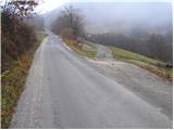 20
20 21
21 22
22 23
23 24
24 25
25 26
26 27
27 28
28 29
29 30
30 31
31 32
32 33
33 34
34 35
35 36
36 37
37 38
38 39
39 40
40 41
41 42
42 43
43 44
44 45
45 46
46 47
47 48
48 49
49 50
50
Discussion about the trip Breg (Liški potok) - Lisca
|
| Gost12. 12. 2007 |
Recommended trip to a very panoramic hill, which is one of the more visited hills south of Zidani most. The path is well marked. The view in good weather is fantastic - from Visoke Tur, Julijci, Grintovci all the way to Velebit and other Zasavje peaks.
|
|
|
|
| Gost12. 12. 2007 |
When I was last at Lisca (last year or the year before last in spring?) I was disappointed by the neglected Tončkov dom. Is it any better now? LpLj
|
|
|
|
| Gost4. 01. 2008 |
We celebrated New Year in Tončkov dom. It was nicely arranged and very well taken care of for the party.
|
|
|
|
| Biser gora15. 03. 2008 |
Nice trip, with an even nicer view. Only the meteorological radar bothers, which really doesn't belong in such wonderful nature. Only the meteorological radar bothers, which really doesn't belong in such wonderful nature.
|
|
|
|
| fpetel111. 04. 2008 |
To the east there is another less frequented but no smaller and equally panoramic hill (peak) Ješivec. From the summit of Lisca 1 hour. At the top there is a bench and the stamp of Sevniške planinske poti.
|
|
|
|
| slavko16. 10. 2011 |
Nice, varied trip. From Lj drive 15 min, moderate hike 1.45. Wonderful view, spacious and well-kept Tončkov dom.....worth the effort to Lisca.
|
|
|
|
| ognjicena23. 11. 2011 |
From Breg to the top just under two hours, nicely maintained and marked path, fog in the valley, of course sun at the top and nice view.
|
|
|
|
| Ajda_Zitnik2. 01. 2012 |
The path is currently slightly slippery in some places, so it requires careful steps there, otherwise it's nice, especially the view from the top is worth seeing.
But I'd note that the hike is in my opinion 2 hours (leisurely).
|
|
|
|
| Kokta8. 01. 2012 |
Hi... today via Jurkova pot from Breg through Razbor past sv. Jošt. Wonderful trail, dry more autumnal than wintery. At the church sv. Jošt it was really windy, while there was no wind at the top. Really nice view in all directions. It might really be a pity that the road leads to Tončev dom, because you somehow lose the feeling of being in the mountains when you see all those cars there by the hut. Perhaps for this reason SPP could include Ješivec instead of Lisca in the booklet, as mentioned by fpetel1. Don't get me wrong, Lisca is otherwise a really "cool" lady . In any case, the trail is very well marked, the food at the hut is excellent so I highly recommend a visit, just please not by car
|
|
|
|
| colinbrooks28. 06. 2012 |
Drive to Breg from Sevnica, and turn right where a sign points to Lisca. About 500m along the road is a car park with a helpful map. You can start your walk from here, but for those walkers who are less energetic [and wish to avoid an uninteresting ascent through the forest> it is better to continue on the road up to the village of Lisce just beyond which there is a marked car park on the left with another map board. Alternatively, from Lisce follow the signs to the delightful village of Rezbor about 1km away. Then walk back along the road to Lisce to enjoy the magnificent views on either side of the ridge. On the map there seems to be a branch road that allows you to drive direct to Rezbor but it is not signposted on the road between Breg and Lisce, so perhaps is not suitable for cars.
From the carpark at Lisce, walk a little further along the road, before turning right onto another tarmac road signposted for Lisca. After about 1km the path up to Lisca begins on the right. However, it is easily missed as it is not signposted [!> and begins on the driveway of a house [!!>. It is most easily located by some white arrows that someone has kindly painted in the road! The path zig-zags up through the forest on a continuous incline but is never steep or hazardous. After about 20 min, you reach Sv. Jost, and then in another 20 min the top where open meadows give spectacular views into the Sava valley [and allow you to jump off in a hang-glider if you have one>. From there, it is a short walk past the koca to the summit where there is an excellent panoramic view, and also a close sight of the meteorological station, the golf-ball tower containing the rainfall radar for the whole of Slovenia. If you are lucky there will be no thunderstorms around, and you can enjoy a well-earned beer in the koca which also has a variety of food at reasonable prices.
A great expedition to one of the premier viewpoints in central Slovenia. The only downside is that it is at least a one and a half hour drive from Ljubljana to Sevnica, albeit through lovely countryside.
|
|
|
|
| KARAMELICA27. 01. 2013 |
Was up there today, great tour, regardless of the snow, as the path is trodden. Sled tracks arranged, many were sledding down from the top at the tower. Great.
|
|
|
|
| Sano4. 12. 2013 |
Not so high, but still nice...yesterday at sunset...
|
|
|
|
| pokerface18. 06. 2015 |
We ask the admin for the description of the new secured path to Lisca.
Thanks!
|
|
|
|
| Daaam18. 06. 2015 |
Go, take photos sit at the computer and write a description. If it's good the adminbz will gladly upload the description cheers.. cheers..
|
|
|
|
| mojčman20. 06. 2015 |
Access description:
Access to the parking lot at the start of the hiking trail above the village of Cerje is possible via an asphalt road from Sevnica. From Sevnica at the first roundabout turn left towards Planina pri Sevnici. After about 5 km in Krakov at the Mastnak winery turn left towards Lisca. Keep right (junction above the chapel) and after 2 km drive we reach the village of Cerje, where above the house with address Podgorica 22, 8290 Sevnica we park at the arranged parking lot at the water intake, where there is also a larger information board. We start walking right along the forest on the asphalt road, which soon ends and continues as a gravel road, after a few tens of meters we turn left into the forest (at the junction there is a larger rock with markings and a direction sign). After a good 10 minutes of walking we reach the start of the very difficult (secured) section of the hiking trail.
Path description:
The section of the path equipped with safety gear consists of 5 pitches (sections secured with cable, installed pegs, steps) total length 123 m. Difficulty: Estimated difficulty is on average B/C, the last pitch between D/E. The peculiarity of the path is that you can descend from each harder section and bypass it on an easier path. The path is equipped with newer technology, larger spacings and lower cable tension with an amortization loop. Use of a via ferrata set is mandatory for walking the path, we also recommend wearing gloves. We also offer equipment rental, more info on our website pd-lisca.si.
Wonderful views open up along the path far around, at the end of the path you can refresh and strengthen in the popular Tončkov dom (www.lisca-dom.com)!
Safe steps to all hikers!
|
|
|
|
| mojčman20. 06. 2015 |
P.S.
this description is published on the PD Lisca page I just copied and pasted it.
You can read it yourself on their website.
|
|
|
|
| mojčman20. 06. 2015 |
P.S.
this description is published on the PD Lisca page I just copied and pasted it.
You can read it yourself on their website.
|
|
|
|
| irska20. 06. 2015 |
the climbing route is now also described on hribi.net
|
|
|
|
| dkrajnc273. 05. 2016 |
Hello
If anyone wants to go towards Lisca on Friday 6.5.2016 around 12:00 please write to me at taxxi3@gmail.com
Old guy from the Celje area
Best
|
|
|
|
| claire26. 02. 2017 |
I didn't start directly from Breg but a bit higher and I have to praise the excellent path marking!
|
|
|
|
| Peter 712. 01. 2022 16:13:16 |
Today I was at the summit. It was sunny spring weather. The Kamnik Alps and Julian Alps as well as Pohorje were clearly visible. At the hut, despite the crowd, I was served quickly! Super hike!
|
|
|
|
| frover12. 04. 2026 11:16:08 |
I was on this trail yesterday. Extended it to Ješivec, on the way back via Sv. Lovrenca. Gentian is already blooming, nice Excellent food at Dom na Lisci, congratulations to the chefs 
The trail is exemplarily marked, thanks to the diligent trail markers
|
|
|
To post a comment you must log in:
If you do not yet have a username, you must first
register.