Brezje pri Tržiču - Dobrča (Po robu)
Starting point: Brezje pri Tržiču (677 m)
| Latitude/Longitude: | 46,35890°N 14,27870°E |
| |
Route name: Po robu
Walking time: 2 h 30 min
Difficulty: easy marked way
Elevation gain: 957 m
Elevation difference along the route: 965 m
Map: Karavanke - osrednji del 1:50.000
Recommended equipment (summer):
Recommended equipment (winter):
Views: 137.693
 | 5 people like this post |
Access to starting point:
From the highway Ljubljana - Jesenice, we take the exit Ljubelj and follow the road ahead in the direction of Tržič. Just before the gas station at Tržič, we turn right (direction Tržič) and then immediately left (direction Begunje) and drive ahead to the village Brezje pri Tržiču, where we park on the parking lot near the church.
Route description:
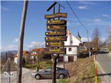
From the parking lot, we continue on the road towards Begunje, but only to the spot where it starts descending. Here, the road which leads to the mountain pasture Bistriška planina branches off to the right (by the crossroad there are also signposts for Dobrča), we walk along it only for a few minutes, and then at the crossroad we go left in the direction of Dobrča (right road leads to the mountain pasture Bistriška planina).
From the crossroad ahead, we continue on a somewhat rougher road, on which we walk for approximately 1 minute, and then the blazes lead us to the right onto a footpath which continues along the fence. For some time we moderately ascend along the fence, and then after approximately 20 minutes of walking from the starting point we arrive at a wide but steep cart track. On the cart track we ascend to a somewhat thinner forest, where the blazes direct us sharply right upward. We then steeply ascend through the forest and after 15 minutes of further walking we arrive at an abandoned trough for animals. Here the path turns to the left and gently ascends below the indistinct peak Vaško. A little further, we arrive at a smaller saddle between the already mentioned peak on the right and the slopes of Dobrča on the left.
A short ascent follows and the path brings us to the spot where we cross the nearby forest road (we cross the road right at the spot where it ends). Further, we ascend for some time along a wide and forested ridge, on which we walk all the way to the paragliding take-off point, which is located on the southern slopes of Dobrča.
Here a wide path branches off to the right, which continues towards the mountain pastures Lešanska and Bistriška planina, and we continue straight and initially walk along the edge of the forest. Quickly we return into the forest and then ascend relatively steeply in zigzags. At an altitude of approximately 1400 meters above sea level, we arrive at a cart track, which we only cross, and then a little higher we arrive at a marked junction, where the path from Lešanska planina joins from the right, a path to the Koča na Dobrči branches off to the left, and we continue straight in the direction of Dobrča.
The path ahead ascends past the holiday cottage and for a short time relatively steeply ascends. When the path flattens, a short descent follows and we join the path which leads from the Koča na Dobrči towards the summit Dobrča. Here we continue right and then in a few minutes we ascend to the summit of Dobrča.

Photos:
 1
1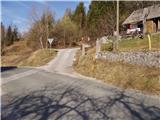 2
2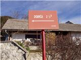 3
3 4
4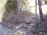 5
5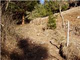 6
6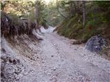 7
7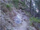 8
8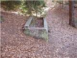 9
9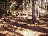 10
10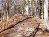 11
11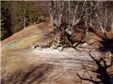 12
12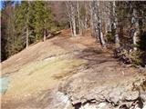 13
13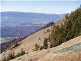 14
14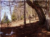 15
15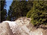 16
16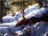 17
17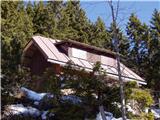 18
18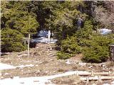 19
19 20
20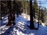 21
21 22
22 23
23 24
24
Discussion about the trip Brezje pri Tržiču - Dobrča (Po robu)
Show older messages
|
| začetnik8. 07. 2008 |
Today at 10am arrived soaking wet to the hut but it is closed maybe someone knows why this is happening, a week ago Saturday around seven in the evening also closed, where is the caretaker, are the huts open after June 15th?
|
|
|
|
| Kriška8. 07. 2008 |
I don't know what's currently happening because I haven't been to this hut for some time, and even if I go to Dobrča (the reasons were debated long ago in some other thread), I would correct you: this hut is not maintained by the hut keeper (who would be accountable to the mountaineering association and employed by it), but the PD has already rented it out to a tenant some time ago.
|
|
|
|
| začetnik12. 07. 2008 |
Got an apology from the caretaker that he had popped out for bread and milk and would come right away if my girlfriend and I called him. Hello, when you're exhausted and know you have two hours to get back, you really don't want to wait.  So today we were there again, only we drove from Zadnja vas quite far to a small shed on the left, from there 20 minutes to the hut. Visibly sweaty, we arrive on the terrace, a man is smoking a cigarette. We greet and barely get a response, order two teas and when he brings the tea dark and stuffy I see conversation won't happen. We pay and head back to the car. View wonderful but such an arrogant and grumpy caretaker we've never seen and won't return. Hope he reads this and reflects a bit, we wanted to talk but didn't dare because of the grim looks. Dobrča beautiful mountain but such snobs harm you. Safe hiking in the mountains and best mountaineering greetings to all Jana. So today we were there again, only we drove from Zadnja vas quite far to a small shed on the left, from there 20 minutes to the hut. Visibly sweaty, we arrive on the terrace, a man is smoking a cigarette. We greet and barely get a response, order two teas and when he brings the tea dark and stuffy I see conversation won't happen. We pay and head back to the car. View wonderful but such an arrogant and grumpy caretaker we've never seen and won't return. Hope he reads this and reflects a bit, we wanted to talk but didn't dare because of the grim looks. Dobrča beautiful mountain but such snobs harm you. Safe hiking in the mountains and best mountaineering greetings to all Jana.
|
|
|
|
| viharnik12. 07. 2008 |
I also notice that in modern times, things still don't work everywhere as they should. Often the hut staff doesn't even know how to advise hikers or where the mountain trails are! Service is often average rather than good. It would be nice if everywhere it was served like at Zavetišče pod Špočkom, Pri Ingotu in Jesenice, Komna, Stol, Tamar and some others - with a smile and good mood!, and best mountaineering regards.
|
|
|
|
| Nickster22. 07. 2008 |
I agree with you. I have been up there twice already
and so far know the conditions well. Otherwise nature is beautiful and maybe I will go up there again sometime.
I admire nature and prefer to ignore rude people. Best regards to all hikers.
|
|
|
|
| dore22. 09. 2008 |
Yeah, there used to be a time when you came to the hut, ordered tea and got it.
Today the caretaker tells you, I'll check if I have it.
|
|
|
|
| andrej jerina22. 09. 2008 |
Dear mountaineers, hikers. I think these forums are intended for exchanging data about the described path, conditions,.. Let's debate prices, caretakers,... if we must, let someone open a topic on the forum and debate there, and let's dedicate these forums to data exchange. I suggest to the site editor to move all mentioned comments to a new topic on this theme. Best regards, Andrej
|
|
|
|
| začetnik3. 12. 2008 |
Finally, the hut has a caretaker who is very friendly to people and the food is also very tasty. I can happily return again to this beautiful panoramic balcony. Best regards, Jana
|
|
|
|
| hostar3. 12. 2008 |
If you're bored after the former one, just head under Stol, it will surely make you happy.
|
|
|
|
| Kriška4. 12. 2008 |
Oh, this is bad news ... it was so nice to do a winter walk there sometimes . .
|
|
|
|
| začetnik18. 12. 2008 |
Has anyone been up there in the last few days, what are the conditions, snow amount or is there a track?
|
|
|
|
| začetnik20. 12. 2008 |
I almost don't believe that no one knows anything, I'll go up myself tomorrow and let you know what the conditions are.
|
|
|
|
| Sam.volk20. 12. 2008 |
Dear Beginner, I read some of your notes and you have the right name beginner. You don't know why you were soaked to the skin on 8.7.2008, well I'll tell you, because you carry an empty backpack to the mountains. And don't rush into the snow now, you'll freeze. Best regards Franc
|
|
|
|
| začetnik22. 12. 2008 |
Sam.wolf first I didn't freeze, secondly my husband and I had a very nice trip because visibility was more than good and the sunshine warmed us. So people go boldly, it's nicely trodden to Hibja, you can drive up nicely too, no snow, at the hut it's almost a meter. We have an 8-year-old son and he had no problems. Safe steps to you
|
|
|
|
| kanjavec2. 01. 2009 |
ŠODROVEC-SKALAŠ
02.01.2009
According to the old rule, one does not go to the mountains with an empty backpack or half-empty. The closer the huts are to settlements or road connections, the more likely they are closed. The huts run by PD are mostly no longer what they USED TO BE!! FINAL ADVICE "TRUST YOURSELF AND YOUR HORSE"!!!
|
|
|
|
| andrej mateja3. 01. 2009 |
We were on Dobrča yesterday, 2.1.. The weather was foggy up to the point where paragliders launch. Above that it cleared up and the view was bombastic. The path is snowy all the way but nicely passable. The track goes to the hut too, where we drank good tea and very good gratinated pancakes with cottage cheese. Pleasant trip for those heading to this peak. Caution with poles, we broke two and had six falls, so we recommend crampons.
|
|
|
|
| Bojan_A4. 01. 2009 |
Dobrča is my mountain running training ground. I was there last 3 days before New Year (28th). And I agree with what's written. I've also broken quite a few sets of poles on this route.
The route is so icy that you can't run at all because it doesn't grip enough. Especially downhill I more or less slid down. With normal walking and good boots it's still somehow okay. Best is of course to have crampons.
|
|
|
|
| kolesar10. 01. 2009 |
Visited Dobrča today after a long time and it was nice. I avoid the hut, if possible.
Enter here
|
|
|
|
| loli17. 01. 2009 |
I'd like to warmly greet all mountaineer friends who like or don't like going to Dobrča. Now everyone is welcome, even those who bring their own food and drink. I'm posting because there was a lot written about it in the past, so I extend a warm welcome to all who love Dobrča from 8.11.08 we, the new tenants-caretakers, are trying to make you feel good in the hut. Thanks to "Kriški", "Začetnik", "Andrej Matej",.... when you come to us, let us know who you are. Welcome, see you on Dobrča. The sun always shines up there, a ray from our hearts for every mountaineer.
|
|
|
|
| jprim18. 01. 2009 |
Yesterday my husband and I were trudging through snow on Dobrča and we also stopped by the hut, I must admit I was pleasantly surprised by the tidiness of the space, it was really pleasant for us, as sometimes you see neglected spaces and dirty tables.
Really praiseworthy.
LP
|
|
|
|
| mukica19. 01. 2009 |
Thanks loli for the encouraging words - welcome to the hut on Dobrča for all mountaineers, even those who take something from the backpack. I'm glad that such tenants still exist, we will gladly stop by you.
|
|
|
|
| kona26. 04. 2009 |
We visited the hut on Dobrča and after a long time were pleasantly surprised by the caretakers, as they were very friendly, and we were also very surprised by their tasty food...
So we will gladly return there in the future and warmly recommend it to other hikers too
|
|
|
|
| wida26. 04. 2009 |
My husband and I also visited the hut and join the praises for the hut caretakers, both for their friendliness and good food.
LP
|
|
|
|
| zabonka25. 08. 2009 |
My boyfriend and I were also on Dobrča today and I must say the hut keepers are really friendly, tea is served like in some inn (with a cookie and lemon alongside) as for the path, it's very nice, we needed only 1h 25 min to the hut
|
|
|
|
| Bojan_A25. 08. 2009 |
Today I was on an evening training on Dobrča. I almost had a heart attack when I reached the top: they cut down such a beautiful rowan tree that adorned the top of Dobrča. From it they made benches. 
That rowan tree is no more (RIP): http://www.2shared.com/file/7376503/6052639a/Kopija_od_Moj_rojstni_dan__048.html
Otherwise, I enjoyed a long time at the top in the last sun rays.
For the ascent from Brezje I needed 44 min 30 s, which is 5 min worse than my personal record. Sometimes it just doesn't go.
|
|
|
|
| majrck29. 09. 2009 |
Yes, all sorts of people go to Dobrča, some for training, others for pleasure, some simply because we love Dobrča. Everyone can write what they want, but Bojan A about the viharnik shouldn't talk like that because it's not quite like that, or maybe I'm wrong and if so please forgive me and tell me where those benches are.
|
|
|
|
| serajko29. 09. 2009 |
Of the viharnik, only the sawn trunks remain, which serve as benches, just as Bojan A wrote. The whole viharnik on top of Dobrča is in pieces. Next to it, one viharnik collapsed on its own because its roots disintegrated.
|
|
|
|
| caplja26. 10. 2009 |
On 25.10. we were at the hut on Dobrča. We felt very comfortable. The staff makes maximum effort to keep the hut neat, food tasty and service excellent.
Tone
|
|
|
|
| Brane7113. 12. 2009 |
Today I visited Dobrča with my friend. Although there were no views, we both enjoyed the winter idyll. In the hut a pleasant atmosphere and friendly caretakers awaited us. Like predecessors wrote, we too join the praises for the caretakers. Food is really excellent and we'll gladly return.
|
|
|
|
| kris25. 04. 2010 |
Today we were on Dobrča, the weather was gorgeous, no snow at all anymore. We had a nice day.
|
|
|
|
| ljubitelj gora10. 12. 2010 |
What are the conditions on this mountain?
Is this path among the easier ones for winter ascent?
|
|
|
|
| JusAvgustin10. 12. 2010 |
The ascent can go via the road, or from Draga. From Draga it's a blast, via the road it's dragging... You ascend through forest in both cases, this year from Dobrča it was phenomenal skiing (powder over the knees!) It's also a summit! not a hut, a beautiful viewpoint. Good luck
|
|
|
|
| Bojan_A10. 12. 2010 |
You don't have to go via the road. If you go from Sv. Neža along the ridge, you have a fairly steep path all the way to the top (my standard winter mountain-running training). Dobrča is almost always safe even in winter. Why almost - on the pasture near Koča na Dobrči, in exceptional and rare cases when huge amounts of snow fall, an avalanche can be triggered. Of course, it's currently completely impossible to think of any avalanche there, because there's little snow. I would only recommend microspikes, as it might slip in places on the path.
|
|
|
|
| Bojan_A30. 01. 2011 |
This year apparently no time yet for mountain running, let alone anything else. But I found time for a run to Dobrča. Conditions for running/hiking still quite good. No snow, except those few cm in the upper ridge part. I expected it to be even more icy. 4-point crampons are not superfluous. Lots of people despite the afternoon hour. Nothing special, but just enough to be "the icing on the cake".
|
|
|
|
| podromk11. 03. 2011 |
The ridge to Dobrča is still a bit icy in some places, so caution won't hurt. The snow cover is steadily melting, so the path will be safer for everyone and Bojan A, whom regular visitors somewhat miss, will be able to run up again without crampons.
|
|
|
|
| darh24. 04. 2011 |
Yesterday we ascended Dobrča via this route, descended via Lešanska and Bistriška planina. In the hut we treated ourselves to excellent raw štruklji, just the portion could perhaps be a bit smaller. We barely managed 10 slices. More about our route and photos can be found here.
|
|
|
|
| jaksa26. 04. 2011 |
Dobrča, beautiful trail from Brezje, hut small but exceptionally friendly and clean. The host is great, little words for a big heart. Food excellent, goulash the best. I felt like at home. I'll definitely come back. Thank you Milan and his wife for the hospitality. This is the real Slovenia that I love and respect so much.
|
|
|
|
| karmen.marolt13. 09. 2011 |
On Sunday we climbed Dobrča with friends. Nice, steep path. In the hut incredibly friendly caretakers. We've visited quite a few peaks already, but haven't experienced such friendliness yet. And not only that, the food is excellent too. http://www.hribi.net/slike/smile.gif
|
|
|
|
| Kokta10. 12. 2011 |
Nice tour, just a bit of fog on top of Dobrča...recommend visiting Šentanski vrh...magnificent view. Currently no snow. The hut is nice, smaller but very well-kept, good food and service
|
|
|
|
| Bojan_A26. 12. 2011 |
Due to bad forecast I didn't go to high mountains. But I did a good training on Dobrča. Snow starts above the bench. But for me it stuck with sneakers - time loss was small. On the way back also to Koča na Dobrči for tea - then to the valley. I was afraid it would be a slide - yes on the path it was. But off the path it was flying to the valley.
|
|
|
|
| Lisica26. 02. 2012 |
The path is dry except just below Dobrča summit a bit of snow and ice. From Dobrča summit to Šentanski vrh is 5 min. On Šentanski vrh the stamp pad is peeled off, but still in the box.
|
|
|
|
| jana196626. 02. 2012 |
Today weather conditions on the path changed - from fog, wind, sun, snowflakes - but must praise the staff at the hut on Dobrča - you won't regret it - order a portion and it will suffice for two hungry ones - praiseworthy! Day was perfect and unforgettable, as I said goodbye to thirty-year-old gojzarjev - everything comes to an end once!
|
|
|
|
| mgrego2229. 04. 2012 |
The path to Dobrča is just right, so you burn quite a few calories. Service excellent, food tasty, portions large. The path from Dobrča to planina Preval is at least for me so far the most gloomy and boring. My husband and I met only one runner, so the path through this forest is not pleasant at all. I could say I have never had such an unpleasant feeling before; the whole thing a bit eerie. We have walked quite a few paths that we return to again and again, but we don't want to repeat these tours. In short Dobrča yes, from there only home.
|
|
|
|
| katty10. 06. 2012 |
This afternoon we walked this path. It was real "biting" in places, especially on those serpentines. But okay. If you're persistent enough and motivation is high, it goes. The path was of course slippery, so we returned via Lešanska and Bistriška planina. No views, shame. I really have no luck with this Dobrča - at least regarding views. Few people, we two started around 15h, met only a friendly and chatty young guy. At the top a young family. The hut will open permanently soon, otherwise on Sundays open until 17h. in places, especially on those serpentines. But okay. If you're persistent enough and motivation is high, it goes. The path was of course slippery, so we returned via Lešanska and Bistriška planina. No views, shame. I really have no luck with this Dobrča - at least regarding views. Few people, we two started around 15h, met only a friendly and chatty young guy. At the top a young family. The hut will open permanently soon, otherwise on Sundays open until 17h.
|
|
|
|
| limona12. 06. 2012 |
On Sunday morning there were quite a few of us on this path despite the wetness - it's excellent for quick drill and preparation for other hikes, as you do almost 1000m ascent "in one breath". At the top the logbook is full, needs replacing. Regards
|
|
|
|
| urosm30. 08. 2012 |
24.8. my girlfriend and I went on this trail. I recommend it, great trail. There's a take-off point in between with a wonderful view. Good recreational training, as you gain 1000m elevation practically without a break.
|
|
|
|
| mgrego2212. 01. 2013 |
Today my husband and I went to Dobrča. The path is beautiful, only the last 30 minutes a bit icy. There was no sunshine, but still a pleasant hike. Mainly I'm writing to praise the food. We ordered a portion of štruklji and I can say that we have never been so pleasantly surprised by the huge portion and good taste anywhere so far. Really all praise to the lady cook and service. I'm convinced that nowhere in Slovenia, whether in the mountains or in a restaurant, would I get such a large portion.
|
|
|
|
| Pohodnica5613. 01. 2013 |
That counts.....good.....especially a large portion
|
|
|
|
| Azemina17. 02. 2013 |
Yesterday walked this path. Great trip and praise to the hut keepers for very tasty food and hospitality.
We will return here
|
|
|
|
| IrenaCe18. 02. 2013 |
Yesss, I was there too... it was great and really all praise to the hut keepers
|
|
|
|
| Swen119. 03. 2014 |
Nice trail, but lots of fallen trees. (ice rain)
The people at the hut are very friendly and portions are huge!
|
|
|
|
| mgrego221. 05. 2014 |
Today May 1st my husband and I were pleasantly surprised at Dobrča. Apparently there's a tradition that hikers get free bean stew on this day. Really nice gesture and praise to the hut keeper. Also praise the service and friendliness of all staff. Bean stew excellent.
|
|
|
|
| smatjaz1. 05. 2014 |
Free bean stew ????? My son and I were up there today too, but no mention of bean stew ?
|
|
|
|
| mgrego226. 05. 2014 |
Yes, you have to arrive early, as it was shared until the huge pot was empty. Sometimes it runs out. Next year earlier, then there will be a snack.
|
|
|
|
| smatjaz6. 05. 2014 |
he, he, he that's how it is if I'm too much "nosy mom" and I first drag to the top and "stared at the empty belly around", then I have to be satisfied with goulash and polenta
|
|
|
|
| zbil7. 07. 2014 |
Yesterday we did a great tour to the top of Dobrča and then to the hut. Attentive staff, Milan, who, by the way, is a very witty gentleman, and the others friendly and quick, portions very appropriate and tasty. We'll come again!
|
|
|
|
| dreamer1. 11. 2014 |
All praise to the new hut keeper and staff at Dobrča!!! Yesterday we climbed up there and in front of the hut they welcomed us with mulled wine, schnapps, zaska and apples (free of charge). When we ordered struklji, the portions were enormous and there was no skimping. After that they brought homemade biscuits and pastries and went around all visitors with a short one. Hats off to the team!!! We'll be back
|
|
|
|
| mgrego2229. 11. 2014 |
Hm, I heard there's a new caretaker and the previous one opened his own pizzeria in Tržič. Does anyone know the name of this pizzeria and where it is located? Otherwise, maybe we'll go tomorrow if the weather is nice to Dobrča to greet the new team. The previous owner was really friendly, full of humor, in short, he'll be missed.
|
|
|
|
| Čeladarka20. 10. 2015 |
Today I was on Dobrča after a few years.
Not much has changed, except ...
At the hut they only have a logbook. Someone obviously took the stamp away. On Šentanski vrh only the plastic handle of the stamp remains. The safest is the one on Dobrča, which is cemented in
The only problem is that for the traverse you need the hut stamp. Why can't it be arranged so that you can stamp also during the week and not only on weekends?!?
|
|
|
|
| grega_z_brega20. 10. 2015 |
You don't go to the mountains just for stamps, do you?
I don't have one yet :P
|
|
|
|
| marinka6721. 10. 2015 |
I'm joining Čeladarka.
Stamps have some purpose, whether it's a traverse where the stamp is proof, for me the stamp in the logbook is the basis for recording a nice adventure, motivation for my nephews... Everyone in their own way. If someone were hiking only for stamps in the mountains, I'd give the book to some friend to stamp it for me, right? No one forces anyone to stamp either. My opinion is, with stamps or without, true mountain lovers already know why we push up. The stamp should be where it belongs, always accessible. The individual's decision is whether to stamp or not, no one has the right to belittle the one who stamps. (hehehe, stamps, my new favorite word)
|
|
|
|
| Aktem18. 03. 2021 |
Hello fellow hikers Has anyone been to Dobrča in these days/weeks or can someone comment if this ascent is currently safe (risk of avalanches etc.)? How is the hut operating on weekends in these strange times? Many thanks and safe hiking steps to you
|
|
|
|
| ppegan18. 03. 2021 |
From the valley you can see that up to the hut it's mostly dry, to the top there's still some snow, so no danger. If I'm not mistaken, the hut is open on weekends or offers take-away food and drinks. Check the hut's FB page, where they regularly post if the hut will be open for the weekend.
|
|
|
|
| Aktem18. 03. 2021 |
Great, many thanks!
|
|
|
|
| KSG13. 07. 2021 20:58:51 |
Beautiful and non-strenuous trail, suitable also for family hiking. And of course delicious food in the hut on Dobrča. Some snapshots from the trail June 2020... https://bit.ly/36Aye5O
|
|
|
|
| Sara Birsa28. 01. 2023 18:24:12 |
Today my husband and I were at the hut on Dobrča. Thank God for the hikers ahead of us who kindly trampled the path. We even had some sunshine At the hut, TOP food and very friendly caretakers. Recommended!
|
|
|
|
| baloncek0521. 05. 2023 14:32:34 |
Excellent service, everyone very friendly. Path excellently marked. But you really have to grind uphill 😃.
|
|
|
|
| Hribolazec818. 02. 2025 18:41:50 |
Hello fellow hikers, since I haven't been to Dobrča yet, I'm interested in which path and from which starting point is the most beautiful and well-marked for Dobrča, the hut on Dobrča and Šentanski vrh, maybe even some circular one
Thanks, and happy hiking
|
|
|
|
| jbs8. 02. 2025 22:57:48 |
Everyone has their own taste, this one along the edge is the most crowded and you can't go wrong... You can make a loop up along the edge and then via Bistriška planina and down the road to the same starting point.
|
|
|
|
| anica.zu13. 02. 2025 15:13:49 |
Hribolazec81
To me, by far the nicest path is from Bistriška planina to Breška planina, from there to the top of Begunjščica and Šentanski vrh. Down to Koča na Dobrči, to Lojzetova (Bibičeva) klop and back to Bistriška planina. Almost entirely circular path.
|
|
|
|
| bbugari113. 02. 2025 18:00:36 |
Dobrča, not Begunjščica...
|
|
|
|
| SaMoMe15. 02. 2025 12:33:53 |
Hello, what are the conditions like for Dobrča? I'd like to go circular past the bench to the hut and to the top and back via Bistriška planina. Thanks for any info.
|
|
|
|
| matjaz-pr28. 06. 2025 15:32:08 |
Today we walked the described path. At the 2nd picture (turn right here) you can drive a few more meters by car, right at the path junction there's space for 10-15 cars.
Nice path (the start to the basin is the most annoying and rough), well marked.
Definitely from the top of Dobrča take another 10 min to Šentanski vrh - exceptional view.
In the hut food is good, košutnikovec too, two young girls very friendly, no problems.
Regarding the circular path - we descended via the forest road/track through Lešanska and Bistriška planina. Circular path, more knee-friendly. However, the road from Bistriška to Brezje drags on.
|
|
|
To post a comment you must log in:
If you do not yet have a username, you must first
register.