Brzika - Boč (via Balunjača)
Starting point: Brzika (380 m)
| Latitude/Longitude: | 46,26720°N 15,71248°E |
| |
Route name: via Balunjača
Walking time: 4 h 10 min
Difficulty: partly demanding marked way
Elevation gain: 598 m
Elevation difference along the route: 895 m
Map:
Recommended equipment (summer): helmet
Recommended equipment (winter): helmet, ice axe, crampons
Views: 304
 | 1 person like this post |
Access to starting point:
a) Drive to Rogaška Slatina, then continue the drive towards Rogatec. In Rogatec, from the roundabout turn "left" towards Ptuj, then drive along the main road to the Brzika pass, where we notice red mountain signposts, beside which we park in a suitable place.
b) Drive to Majšperk, then follow the signs to Stoperce and Rogatec. After Stoperce, the road begins to climb more steeply, and we follow it to the Brzika pass, where we notice red mountain signposts, beside which we park in a suitable place.
Route description:
From the starting point we continue a few dozen steps along the asphalt road towards Stoperce, then go left onto the side road, beside which there are signs for Ložno. There follows some ascent through the forest, then the road levels out and leads us through the courtyard of the farmstead. After the farmstead we descend along the marked cart track, which lower down enters the forest, but we leave it at the entrance to the forest and continue slightly left on the footpath, along which we ascend again. There follows a short descent, where we cross the high-pressure gas pipeline route, then we ascend more steeply for a few minutes. Higher up we bypass the unnamed 499-meter high peak on the left side (unnamed on maps), after which there is some moderate descent, then ascent to the next unnamed peak. From there too there is some descent, lower down we reach the cart track, along which we continue to the excursion farm Ložno, where we continue right towards Boč (left Church of Mary of Loreto at Ložno, 5 minutes).
There follows a few minutes of moderate ascent, then the path enters the forest, where along the cart track it crosses the slopes to the left. A little further on we approach some houses, but along the fence we reach the road, along which we descend in a few minutes to the asphalt road, which we follow to the right. There follows some walking along the asphalt road, where we go under the high-voltage power line route, then from the right the path from Okrepčevalnica Zelena dolina joins us.
There follows an ascent along the asphalt road, from which we occasionally get a nice view of the surrounding hills, higher up the road levels out and takes us past a chapel to the hamlet of Ravnocerje.
Here we go behind the farmstead on the right, right onto the marked cart track along which we ascend to the marked junction, where we join the path from Cerovca pod Bočem.
The path ahead ascends transversely along the cart track and quickly brings us to the ridge west of Ravnocerje. Here the path turns slightly left (sharply right summit Ravnocerje 3 minutes) and leads us past the water we see under the path. For a short time we continue along the forested ridge, then the path turns right and passes to the slope, where at a few junctions we follow the marks. Higher up we go left from the cart track onto the marked footpath (the cart track a little further joins the forest road), beside which we notice a sign saying forest reserve Boč. The path ahead on the left, sunny side bypasses the highest point of Plešivec, which is on an indistinct summit, then we gradually begin to descend. Lower down we reach a marked junction, where we join the path from Cerovca pod Bočem, and we continue to the nearby road.
When we reach the road we go left, and left again at the nearby intersection (right Makole). There follows some descent along the gravel road, when we leave the forest we pass a landmark to the intersection, from which we go straight (left leads the road down the valley towards Rogaška Slatina) and bypass the Gavez farmstead on the left side, and the nearby Rogaška Slatina hunting lodge on the right.
Behind the lodge we descend to the other road and follow it to the right. When the road starts to ascend, a marked path branches off to the right leading towards Formili and Makole, but we continue along the asphalt road which starts to ascend. After a short ascent the road forks, and we continue along the slightly left road which starts to descend (slightly right road leads to a private house). There follows a descent along the gravel road, which brings us a bit lower to the intersection, where we go right downhill towards Boč. We continue descending, at the next intersection where we join the path from Makole we go left. Just a little further we go right. From the last intersection we walk along the road only a short time, then go left onto the marked path, which ascends along the cart track to the place where there once stood a forester's hut, now a new hut is being built (status May 2022).
Here we step back onto the road, which we follow to the left (across the road there is an unmarked path to Boč, or we can join the road leading towards Boč). Further on we walk along the road which crosses the slopes of Boč to the left, along it we first still ascend gently, later we also descend a bit along it.
A few dozen steps before reaching the asphalt road, a shady path to Boč branches off to the right, but we continue to the road, where we continue right. When the road turns left, we continue slightly right and continue along the poorer road that goes into the forest, at the junction we go right in the direction of the path via Balunjača and in the direction of the climbing path to Boč (left downhill Dom na Boču - 2 minutes).
The path ahead leads us along a gentle road that ascends transversely to the left and crosses the power line route. When we reach the southwest ridge of Boč, Detičkova path from Zgornje Poljčane joins us from the left, and we continue along the road to its end at the turning area.
We continue left along the trodden, improved and partly fenced path, which soon brings us to a junction, where we leave the usual easy path to Boč. We head left in the direction of the climbing path and the path via Balunjača. There follows a shorter, fairly level transverse ascent to the left to the cliffs, where the first protections appear. The path is not particularly demanding, but especially in spring and after rain it is exposed to falling rocks.
At the beginning of the secured section, a very demanding secured path to Boč branches off to the right, but we continue straight in the direction of the path via Balunjača. There follows a transverse ascent along the steep slope, where special caution is needed especially when wet. After the next secured section we arrive at the Balunjača cave, a few dozen steps further there is another cave. The steepness of the slope above the caves eases a bit, the path turns right and ascends transversely above the steep part. When the terrain levels out, the climbing path joins us from the right.
We continue slightly left and at the red mountain signposts join the usual path. Further on we follow the marks to the fenced military area, which we bypass on the right side. For a short time we walk without major changes in elevation, then we ascend again and quickly reach the summit of Boč with the viewpoint tower. In good weather it is worth climbing it, as it offers a wonderful view in all directions.

Photos:
 1
1 2
2 3
3 4
4 5
5 6
6 7
7 8
8 9
9 10
10 11
11 12
12 13
13 14
14 15
15 16
16 17
17 18
18 19
19 20
20 21
21 22
22 23
23 24
24 25
25 26
26 27
27 28
28 29
29 30
30 31
31 32
32 33
33 34
34 35
35 36
36 37
37 38
38 39
39 40
40 41
41 42
42 43
43 44
44 45
45 46
46 47
47 48
48 49
49 50
50 51
51 52
52 53
53 54
54 55
55 56
56 57
57 58
58 59
59 60
60 61
61 62
62 63
63 64
64 65
65 66
66 67
67 68
68 69
69 70
70 71
71 72
72 73
73 74
74 75
75 76
76 77
77 78
78 79
79 80
80 81
81 82
82 83
83 84
84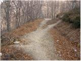 85
85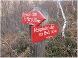 86
86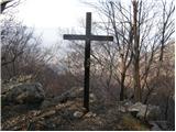 87
87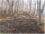 88
88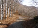 89
89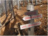 90
90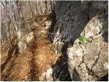 91
91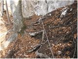 92
92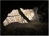 93
93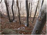 94
94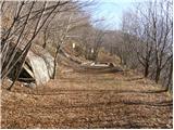 95
95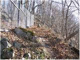 96
96 97
97 98
98 99
99 100
100 101
101 102
102 103
103
Discussion about the trip Brzika - Boč (via Balunjača)
To post a comment you must log in:
If you do not yet have a username, you must first
register.